
Kilearnan


Cultivation Remains (Period Unassigned), Farmstead (Period Unassigned), Kiln(S) (Period Unassigned), Township (Period Unassigned)
Site Name Kilearnan
Classification Cultivation Remains (Period Unassigned), Farmstead (Period Unassigned), Kiln(S) (Period Unassigned), Township (Period Unassigned)
Alternative Name(s) Wester Kilernan; Easter Kilernan
Canmore ID 7071
Site Number NC91NW 22
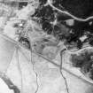
NGR NC 923 193
NGR Description NC 923 193 to NC 929 190
Datum OSGB36 - NGR
Permalink http://canmore.org.uk/site/7071


- Council Highland
- Parish Kildonan
- Former Region Highland
- Former District Sutherland
- Former County Sutherland
NC91NW 22.00 923 193 to 929 190.
NC91NW 22.01 NC 923 193 Farmstead; Kiln
NC91NW 22.02 NC 929 190 Township; Cultivation Remains
Centred NC 9235 1900. Kilurnan: Shown as a group of about four buildings with arable.
W Roy 1747-55.
"Wester Kilernan" and "Easter Kilernan". "Wester" - shows about 3 buildings. "Easter" shows about 10 buildings in the western group and about 8 buildings in the eastern group, around the present farmhouse - all roofed.
Information from Estate Map of Strath Kildonan, pre 1815, held at Dunrobin estate office.
Centred NC 9235 1938 - "Wester Kilernan", an area of depopulation comprising the footings of 3 buildings, and a kiln at NC 9236 1935. The foundations vary from 6 x 3m to 15 x 3m with walls 0.3m high. The railway line cuts through the site. A fragment of an earth-and-stone dyke to the W of the site may indicate that it was enclosed on this and the S side - natural features bound it on the N, E and SE.
Centred NC 9290 1900 "Easter Kilernan". The exisiting foundations here have been considerably destroyed due to extensive agricultural improvements. 3 kilns were identified at NC9289 1906; 9293 1890 and
9294 1887.
At NC 9289 1903, is a large mound of earth and stone measuring 20 x 17m overall and c.2m high. Within this much-disturbed area is a double cavity 12 x 6 m overall, in which a recent dry-stone construction has been erected. The feature has the characteristics of having been a limekiln.
Visited by OS (J L D), 30 May 1961.

