
Allt Cille Pheadair


Field System (Period Unassigned), Hut Circle(S) (Prehistoric)
Site Name Allt Cille Pheadair
Classification Field System (Period Unassigned), Hut Circle(S) (Prehistoric)
Alternative Name(s) Kilphedir
Canmore ID 7003
Site Number NC91NE 3
NGR NC 9920 1943
NGR Description NC 9917 1945 and NC 9922 1941
Datum OSGB36 - NGR
Permalink http://canmore.org.uk/site/7003


![Publication drawing; plan of 'Hut Circle [B], Allt Cille Pheadair'.](http://i.rcahms.gov.uk/canmore/l/SC01665104.jpg)


![Publication drawing; plan of 'Hut Circle [B], Allt Cille Pheadair'.](http://i.rcahms.gov.uk/canmore/s/SC01665104.jpg)


- Council Highland
- Parish Kildonan
- Former Region Highland
- Former District Sutherland
- Former County Sutherland
NC91NE 3 9920 1943
See also NC91NE 25.
(A: NC 9917 1945, B: NC 9922 1941) Enclosures (NR)
OS 6" map, 1964.
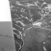
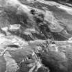
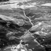
Due E of a hut circle group (NC91NE 25), on the opposite bank of Allt Cille Pheadair, are two hut circles. The more southerly example (B) appears to be placed within an oval enclosure. On the W side of the entrance is a small chamber entered through a passage, with a lintel at its inner end. This may be the entrance to an earth-house.
RCAHMS 1911, visited 1909.
Two hut circles as described.
Visited by OS (W D J) 20 May 1960.
On a gentle S-facing slope in open moorland, are two well-preserved stone-walled huts within an associated field system. The huts appear to be broadly similar in size and construction. 'A' measures 9.0m NW-SE by 8.5m transversely within a heather-covered wall, 2.8m thick all round, which is faced inside and out with large stones on edge. The 'simple' entrance is in the SE arc. Hut 'B' (at corrected grid reference NC 99201941) is 9.0m internal diameter within a rubble wall about 2.0m to 3.0m thick, faced internally with a crude uncoursed wall of large stones, 1.0m high, the flatter side of the stone facing the inside of the hut. The wall thickens at the entrance in the SE arc to 4.0m; portal stones indicate the passage was 1.1m wide with parallel sides. The depression in the wall on the W side of the entrance may be the tumbled remains of a souterrain, but an absence of visible wall facing renders this uncertain. The hut appears to have been built within an earlier hut which was set into the hillslope and measured approximately 11.0m NW-SE by 9.5m within a heather-covered wall spread, where visible, to 2.5m. Two inner facing slabs are visible in the NW arc. The huts appear to share a common entrance in the SE.
The associated field system of 1 1/2 hectares comprises cleared plots, average size 40.0m by 30.0m defined mainly by lynchets and one or two field walls. There is little evidence of clearance heaps.
Re-surveyed at 1:10,560.
Visited by OS (N K B) 21 October 1976.

