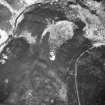
 |
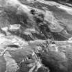
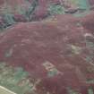
On-line Digital Images |
SC 1693349 |
RCAHMS Aerial Photography |
Oblique aerial view. |
1991 |
Item Level |
|
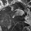 |
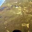
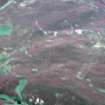
On-line Digital Images |
SC 1693350 |
RCAHMS Aerial Photography |
Oblique aerial view. |
1991 |
Item Level |
|
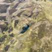 |
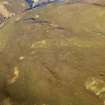
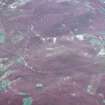
On-line Digital Images |
DP 080107 |
RCAHMS Aerial Photography Digital |
Oblique aerial view centred on Kilphedir Broch with the small cairns and hut-circles adjacent, taken from the ESE. |
29/5/2009 |
Item Level |
|
 |
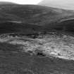
On-line Digital Images |
SC 1875011 |
|
|
1982 |
Item Level |
|
 |
On-line Digital Images |
SC 1875012 |
|
|
1982 |
Item Level |
|
 |
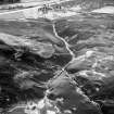
On-line Digital Images |
SC 1896341 |
Papers of James Sloan Bone, landscape historian, Inverness, Highland, Scotland |
An oblique aerial view of Kilphedir Broch, Strath of Kildonan, East Sutherland, looking NE. |
1998 |
Item Level |
|
 |
On-line Digital Images |
SC 1896342 |
Papers of James Sloan Bone, landscape historian, Inverness, Highland, Scotland |
An oblique aerial view of the slopes east of the Allt Cille Pheadair, Strath of Kildonan, East Sutherland, looking N. |
1998 |
Item Level |
|
 |
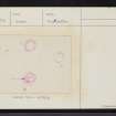
On-line Digital Images |
SC 1924266 |
Dr Joanna Close-Brooks |
J.Close-Brooks |
1985 |
Item Level |
|
 |
On-line Digital Images |
SC 1944777 |
Papers of James Sloan Bone, landscape historian, Inverness, Highland, Scotland |
Aerial view of Kilphedir Broch, Cairns and roundhouse settlement, Strath of Kildonan looking NNW. |
1/9/1998 |
Item Level |
|
 |
On-line Digital Images |
SC 1944779 |
Papers of James Sloan Bone, landscape historian, Inverness, Highland, Scotland |
Aerial view of Kilphedir Broch, near Helmsdale, East Sutherland, looking E. |
1/9/1998 |
Item Level |
|
 |
On-line Digital Images |
SC 1944780 |
Papers of James Sloan Bone, landscape historian, Inverness, Highland, Scotland |
Aerial view of Kilphedir Broch, near Helmsdale, East Sutherland, looking NE. |
1/9/1998 |
Item Level |
|
 |
On-line Digital Images |
SC 2350548 |
Records of the Ordnance Survey, Southampton, Hampshire, England |
Allt Cille Pheadair, NC91NE 28, Ordnance Survey index card, page number 1, Recto |
1958 |
Item Level |
|
 |
On-line Digital Images |
SC 2350549 |
Records of the Ordnance Survey, Southampton, Hampshire, England |
Allt Cille Pheadair, NC91NE 28, Ordnance Survey index card, page number 2, Verso |
1958 |
Item Level |
|
 |
On-line Digital Images |
SC 2350550 |
Records of the Ordnance Survey, Southampton, Hampshire, England |
Allt Cille Pheadair, NC91NE 28, Ordnance Survey index card, Recto |
1958 |
Item Level |
|
 |
On-line Digital Images |
SC 2350551 |
Records of the Ordnance Survey, Southampton, Hampshire, England |
Allt Cille Pheadair, NC91NE 28, Ordnance Survey index card, Recto |
1958 |
Item Level |
|
 |
On-line Digital Images |
SC 2350552 |
Records of the Ordnance Survey, Southampton, Hampshire, England |
Allt Cille Pheadair, NC91NE 28, Ordnance Survey index card, Recto |
1958 |
Item Level |
|
|
All Other |
551 359/457/12/1 |
General Collection |
Photographic prints from survey of Souterrain at Allt Cille Pheadair, Kildonan, Sutherland |
|
Batch Level |
|
|
All Other |
551 359/457/12 |
General Collection |
Archive from Souterrain at Allt Cille Pheadair, Kildonan, Sutherland |
19/9/1990 |
Sub-Group Level |
|
|
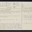
All Other |
551 166/1/1 |
Records of the Ordnance Survey, Southampton, Hampshire, England |
Archaeological site card index ('495' cards) |
1947 |
Sub-Group Level |
|


