
Pricing Change
New pricing for orders of material from this site will come into place shortly. Charges for supply of digital images, digitisation on demand, prints and licensing will be altered.
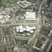
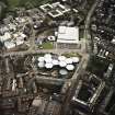
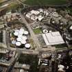
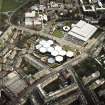
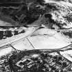
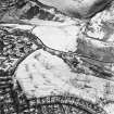
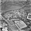
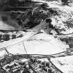
Edinburgh, Holyrood Park Road, Pollock Halls Of Residence


Hall Of Residence (Modern)
Site Name Edinburgh, Holyrood Park Road, Pollock Halls Of Residence
Classification Hall Of Residence (Modern)
Alternative Name(s) University Of Edinburgh; Dalkeith Road
Canmore ID 69994
Site Number NT27SE 528
NGR NT 2700 7243
Datum OSGB36 - NGR
Permalink http://canmore.org.uk/site/69994


First 100 images shown. See the Collections panel (below) for a link to all digital images.
- Council Edinburgh, City Of
- Parish Edinburgh (Edinburgh, City Of)
- Former Region Lothian
- Former District City Of Edinburgh
- Former County Midlothian
REFERENCE : There is a catalogue slip that states that David Bryce is the architect of Pollock Halls, St Leonard's but this is incorrect or misfiled.
NMRS Print Room
Pollock Halls
Detail of OS plan showing house and grounds of St Leonards including glasshouses, observatory, etc
Inglis Photograph Collection
Acc No 1994/90
See also NT27SE 1748, Salisbury Green
and NT27SE 2638, St Leonard's Hall
Publication Account (1997)
An elegantly formal enemble of severly classical buildings, ranged around two open courtyards. Most of the group comprises residence blocks, with rendered walls and shallow copper roofs, some with slender lanern towers. The axial focus of the project is a large dining hall, fronted by a slender arched concrete conolnnade of a loosely Renaissance character. (Fig. 4.23).
Information from 'Rebuilding Scotland: The Postwar Vision, 1945-75', (1997).
Excavation (14 January 2002 - 29 January 2002)
Kirkdale Archaeology were asked to maintain a watching brief between the 14th and the 29th of January 2002 while contractors cut a deep pipe trench in the west of Holyrood Park close to the boundary wall separating the park from Pollock Halls of residence. The purpose of the works was to put in place a waste water pipe. The pipe is intended to channel away surface rain water from the new development being created on the N side of the Halls of Residence. The trench for the pipe would commence to the W of the boundary wall and would run eastwards below the wall into the park at which point it would turn S and would run through the park to join up with an existing drain pipe which in turn would exit into settlement ponds near Duddingston Loch.
The absence of archaeological features or finds in this area of the Park may be the result of landscaping related to the building of the park road and footpath or it may be that this area was simply left to agricultural or park activity.
G Ewart 2002
Sponsor: Historic Scotland
Kirkdale Archaeology

