
Hoddom


Corn Drying Kiln (Medieval) - (Post Medieval), Enclosure (Medieval) - (Post Medieval), Inscribed Stone (Roman), Kiln(S) (Medieval) - (Post Medieval), Linear Feature(S) (Period Unknown), Monastery (Anglian)(Possible)
Site Name Hoddom
Classification Corn Drying Kiln (Medieval) - (Post Medieval), Enclosure (Medieval) - (Post Medieval), Inscribed Stone (Roman), Kiln(S) (Medieval) - (Post Medieval), Linear Feature(S) (Period Unknown), Monastery (Anglian)(Possible)
Alternative Name(s) Hallguards Quarry; Hoddom Church; Hoddom 'chapel'
Canmore ID 69504
Site Number NY17SE 56
NGR NY 16800 72800
NGR Description NY 166 729 to NY 169 727
Datum OSGB36 - NGR
Permalink http://canmore.org.uk/site/69504


- Council Dumfries And Galloway
- Parish Hoddom
- Former Region Dumfries And Galloway
- Former District Annandale And Eskdale
- Former County Dumfries-shire
RCAHMS Archive: Canmore ID 69504; site number NY17SE 56 done
Hoddom 70, Dumfriesshire, cross-slab
Measurements: H 0.38m, W 0.25m, D 0.07m
Stone type: reddish sandstone
Place of discovery: NY 1680 7289
Present location: Dumfries Museum.
Evidence for discovery: found in 1991 amongst the collapsed NE corner of the wall of Hoddom graveyard.
Present condition: broken and very damaged.
Description
This fragment belongs to a plain cross-shaft (though one broad face is missing). It has two incised lines along the vertical edges, one deeper than the other.
Date: eighth or ninth century.
References: Craig 2006, 127-8 (SF1352).
Desk-based information compiled by A Ritchie 2019.
Hoddom 76, Dumfriesshire, cross-incised slab
Measurements: H 0.11m, W 0.10m, D 0.03m
Stone type: reddish sandstone
Place of discovery: NY 1680 7289
Present location: Dumfries Museum.
Evidence for discovery: found during excavations in 1991 amongst the upper stony layer that overlay feature S1.
Present condition: broken.
Description
One face of this irregular slab is incised with a simple linear cross.
Date: uncertain.
References: Craig 2006, 131-2 (SF151).
Desk-based information compiled by A Ritchie 2019.
Hoddom 77, Dumfriesshire, cross-head
Measurements: H 0.19m, W 0.17m, D 0.15m
Stone type: sandstone
Place of discovery: NY 1680 7289
Present location: Dumfries Museum.
Evidence for discovery: found by W F Cormack after ploughing in 1992 to the east of Hoddom graveyard.
Present condition: broken and worn.
Description
This fragment is part of the terminal of an arm of a cross-head, carved in relief with a roll moulding. On face A a trilobed berry bunch is tucked into the corner, with a pointed leaf below, but face B appears to have been plain apart from an inner roll moulding.
Date: eighth or ninth century.
References: Lowe 2006, 23-4, fig 3.6.
Desk-based information compiled by A Ritchie 2019.
Hoddom 71, Dumfriesshire, cross-slab
Measurements: H 0.31m, W 0.22m, D 0.04m
Stone type: red sandstone
Place of discovery: NY 1680 7289
Present location: Dumfries Museum.
Evidence for discovery: found during ploughing NE of Hoddom graveyard.
Present condition: broken and very damaged.
Description
This fragment is a corner of a slab incised with an outline cross. It shows parts of two arms with squared terminals and a rounded armpit, one arm shorter than the other and abutting the edge of the slab.
Date: eighth or ninth century.
References: Craig 2006, 128 (SF32).
Desk-based information compiled by A Ritchie 2019.
Hoddom 67, Dumfriesshire, cross-slab
Measurements: H 0.55m +, W 0.45 > 0.39m, D 0.06m
Stone type: pinkish-beige sandstone
Place of discovery: NY 1680 7289
Present location: Dumfries Museum.
Evidence for discovery: found during ploughing in 1991 to the east of Hoddom graveyard.
Present condition: broken into four pieces and incomplete.
Description
Carved in relief on one broad face only, this slab displays a white cross against a red background, utilising the natural colour banding in the stone. The top corners of the slab are rounded, and the upper cross-arm extends to the upper edge of the stone. The side and upper arms of the cross have double-curved cusped terminals with widely curving armpits, while the lower, slightly shorter, arm is wedge-shaped. A short shaft links the cross-head to a square two-stepped base.
Date: mid ninth century.
References: Craig 2006, 124-6 (SF50/1353).
Desk-based information compiled by A Ritchie 2019.
Hoddom 68, Dumfriesshire, cross-shaft
Measurements: H 0.29m, W 0.17m, D 0.13m
Stone type: reddish sandstone
Place of discovery: NY 1680 7289
Present location: Dumfries Museum.
Evidence for discovery: surface find in 1991 to the north-east of Hoddom graveyard.
Present condition: broken and very damaged.
Description
This fragment belongs to a plain cross-shaft (though one broad face is missing). It has two incised lines along the vertical edges, one deeper than the other.
Date: eighth or ninth century.
References: Craig 2006, 126 (SF1350).
Desk-based information compiled by A Ritchie 2019.
Hoddom 69, Dumfriesshire, cross-slab
Measurements: H 0.62m, W 0.66m, D 0.06m
Stone type: reddish sandstone
Place of discovery: NY 1680 7289
Present location: Dumfries Museum.
Evidence for discovery: found after ploughing in 1991 to the east of Hoddom graveyard.
Present condition: broken into one large and several small fragments, incomplete and damaged.
Description
Carved on one broad face only, this slab bears an incised cross filling an incised panel. The three intact upper arms are equal in length and cusped, with wide curved armpits, and there is a small drilled laying-out hole at the centre of the cross-head.
Date: ninth century.
References: Craig 2006, 126-7 (SF26).
Desk-based information compiled by A Ritchie 2019.
Hoddom 73, Dumfriesshire, cross-slab
Measurements: H 0.19m, W 0.30m, D 0.09m
Stone type: red sandstone
Place of discovery: NY 1680 7289
Present location: Dumfries Museum.
Evidence for discovery: found in 1991 amongst the collapsed NE corner of the wall of Hoddom graveyard.
Present condition: broken and damaged.
Description
This fragment belongs to a slab carved in relief on both broad faces with a cross with wedge-shaped arms and a circular centre. On both faces one complete and two partial arms survive, representing the side and lower arms. On face A the arms of the cross have a roll moulding, interrupted on the lower arm by a very short incised stem, but the arms on face C are plain.
Date: uncertain.
References: Craig 2006, 129 (SF29).
Desk-based information compiled by A Ritchie 2019.
Hoddom 74, Dumfriesshire, cross-slab
Measurements: H 0.19m, W 0.38m, D 0.07m
Stone type: red sandstone
Place of discovery: NY 1680 7289
Present location: Dumfries Museum.
Evidence for discovery: found in 1991 amongst the collapsed NE corner of the wall of Hoddom graveyard.
Present condition: broken and damaged.
Description
The back of this fragment has been removed. On face A there is the upper part of a cross carved in relief, with wedge-shaped arms and a circular centre, all outlined by a roll moulding. It appears to match the lower half represented by Hoddom 29, but the lithology of the two pieces is not, apparently, identical.
Date: uncertain.
References: Craig 2006, 129-31 (SF27).
Desk-based information compiled by A Ritchie 2019.
Hoddom 75, Dumfriesshire, cross-slab
Measurements: H 0.21m, W 0.19m, D 0.04m
Stone type: red sandstone
Place of discovery: NY 1680 7289
Present location: Dumfries Museum.
Evidence for discovery: found in 1991 amongst the collapsed NE corner of the wall of Hoddom graveyard.
Present condition: broken and very damaged.
Description
Only one face of this fragment is intact and bears parts of two wedge-shaped cross-arms carved in relief.
Date: uncertain.
References: Craig 2006, 131 (SF33).
Desk-based information compiled by A Ritchie 2019.
Hoddom 72, Dumfriesshire, cross-slab
Measurements: H 0.38m, W 0.25m, D 0.07m
Stone type: red sandstone
Place of discovery: NY 1680 7289
Present location: Dumfries Museum.
Evidence for discovery: found in 1991 amongst the collapsed NE corner of the wall of Hoddom graveyard.
Present condition: broken and trimmed for re-use.
Description
This fragment is part of the central portion of a cross-slab and is incised by four lines forming a tapering shaft.
Date: eighth or ninth century.
References: Craig 2006, 128-9 (SF34).
Desk-based information compiled by A Ritchie 2019.
NY17SE 56 168 728
See also NY17SE 4.00. For Anglian cross-shaft possibly from Hoddom, see NY17SE 60.
For fragment of cross-shaft found at Kirklands House (NY 1887 7229) and possibly from this site, see NY17SE 61.01.
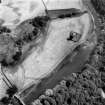
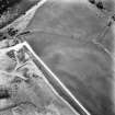
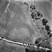
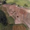
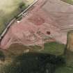
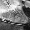
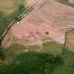
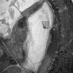
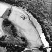
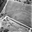
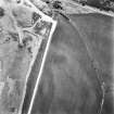
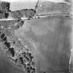
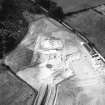
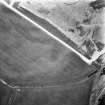
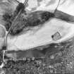
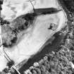
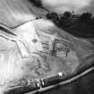
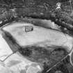
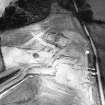
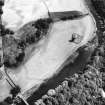
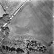
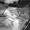
(Formerly classified as Linear Cropmarks). This excavated site, threatened by quarrying, is located on a gravel terrace, some 250m distant from the site of Hoddom Old Parish Church (NY17SE 4.00), which is broadly datable to the 8th century. A combination of field assessment, magnetometer and aerial surveys, large scale open-area excavation, and a post-ploughing survey of the lower field around the graveyard were carried out. (For the results of the last-mentioned, see NY17SE 4.02). The site is bounded by the river to the S, and to the N, E and ?W by a ditch, the whole forming a curvilinear enclosure with the church located S of centre. The ground enclosed extends to roughly 8ha (20 acres). The ditch was roughly 2.6m to 3m wide and 1m deep in its eroded state. It was exposed over a distance of 250m and traced elsewhere as a cropmark and geophysical anomaly. It appears to rise near the river in the E (at NY 1696 7272), extends across the upper terrace and skirts the margins of a low, now denuded, knoll to the W before seemingly dropping down to the river, W of the church site (at NY 1659 7263). The ditch was associated with a palisade slot or fence-line and in those areas to the W, where the site was buried by a deep topsoil, the remains of a bank were also preserved. In these areas the elements of the enclosure comprised, internally to externally, a bank, palisade, berm and ditch. Minor realignments in the course of the ditch, manifested as recuts, were also noted.
A large number of buildings, with little sign of activity in between, were located at more or less regular intervals around the perimeter of the enclosure. These were investigated through open-area excavation (see paras. B-E). Prospective excavation, to investigate those areas within the enclosure which were seemingly devoid of cropmark or geophysical anomalies, was also undertaken (see paras. F, G, I, J). A complex of additional structures and features in the northern part of the field, seemingly unrelated to the monastic phase of occupation on the site, was also recorded during the watching brief. Some of these were excavated (para H). Others were salvaged in advance of quarrying.
A: Four keyhole excavations of the ditch and other cropmark features were undertaken, cutting the ditch at NY 1677 7291, 1678 7290 and NY 1687 7283. Charcoal from secondary ditch fill at NY 1677 7291 was radiocarbon dated to 920 +/- 50 ad (GU-2984).
B: At NY 1676 7290, a large post-built structure lay adjacent to the palisade trench and enclosure ditch, no trace of a bank surviving in this part of the site. At least two phases of occupation were noted. The building was trapezoidal and measured roughly 16.5m long, 6.9m wide at the north and 4.8m wide at its south end. The side walls were slightly bowed and the remains of an internal partition wall survived towards the south end of the building. A possible entrance was traced near the north end of the east wall-line. A primary hearth was sited in the centre, near the north end of the building. Part of the primary clay floor also survived. A subcircular stone-lined, sunken structure was subsequently inserted into the northern end of the building. It was associated with
a series of post-holes, much daub and burnt clay. This feature is interpreted as a possible timber and clay-domed bread-oven. Few finds were recovered. A series of radiocarbon dates suggest that the building can be assigned to the 7th or 8th centuries AD. Similar radiocarbon dates were also recovered from primary ditch fill material and the adjacent palisade trench.
C: At NY 1674 7292, a large sunken-featured building, of at least two phases of construction, lay adjacent to the enclosure ditch and was partially built over the course of the palisade trench. The building was sub-rectangular, roughly 7.8m by 5.8m and up to 75cm deep at its south end. The north end however had been left higher, to accommodate the base and sides of an oval stone feature, up to 3m across. The primary, post- built, timber construction, with large post-pits to the south of the centre of the building, was subsequently partially refurbished in stone after an early conflagration. A sunken, protruding, entrance, 1.2m wide and long, was located at the south-east corner of the building. The structure was filled with charcoal-rich deposits, containing animal bone. It is interpreted as a possible 'smoke-house' for curing meat. The building is similar in form to Middle Saxon examples from Dorchester and Sutton Courtenay.
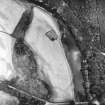
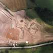
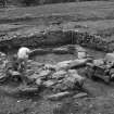
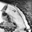
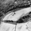
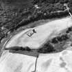
D: In the excavated area centred at NY 1670 7292, the major features comprised a palimpsest of at least three post-built timber structures and the well-preserved remains of a multi-phase, stone-built corn- drying kiln. The kiln-house was sunken below the contemporary ground surface, cutting through the enclosure bank and partially intruding upon the backfilled ditch to the north. At least one of the adjacent timber buildings was also truncated at this time. The kiln-house was square, roughly 5.9m across within walls up to 1m wide and high. The walls, constructed of crudely coursed large sandstone blocks, were faced internally and bonded with clay. Traces of a clay render were also present. Single post-holes were located at each corner of the building and the remains of the kiln-bowl, 4.3m in diameter, lay in the centre. The north wall of the building was subsequently revetted internally and a second kiln, of 'keyhole'-type, was erected over the remains of the earlier feature. The flue extended through the entrance to the building, terminating at an external hearth. Traces of a second flue, possibly fired from the same hearth, may have serviced a second kiln to the south of the building. At a relatively late date in its history, the building and a crude annexe or yard to the east were filled with slag and other debris.
The clear ground-plans of at least two large post-built timber structures were recognised in the area to the south of the kiln-house. Both lay parallel with the ditch and appear to predate the connstruction of the kiln-house. One, 13.5m by 6.75m, was subrectangular with slightly bowed walls. A second building, immediately to the southwest, was slightly longer (15m) and its wall-lines more bowed. The possible remains of a third building, on a different alignment to the others and truncated by the kiln-house, have also been recognised.
E: Excavation in the area centred NY 1668 7290 is still on-going. The principal features comprise the enclosure ditch and bank, a series of sunken-featured buildings, an early pre-bank stone building and a large post-built timber structure.
Three of the sunken-featured buildings are relatively late. One, an extremely large sunken-featured building, has been cut through the backfill of the ditch and appears to be associated with metal-working activity. The function of the other two structures is less clear.
The enclosure bank was well-preserved in this area and from it was recovered a crude cross-incised pebble. These deposits sealed the remains of a sunken stone structure. The building, oriented east-west, measured 4.5m by 2.6m within walls 70cm to 80cm wide and 1m high. It was constructed of square dressed sandstone blocks, possibly material robbed from the Roman fort at Birrens (NY27NW 4). The masonry was clay- bonded and also contained a fragment of a Roman inscription ()VMIN ( ) ()ENET.?RI( ) ()?DIC( ), possibly of the late 2nd century AD. No trace of an entrance into the building was located. It may have been sited in an overlying timber super-structure. A long, steep passage or soak-away was located at the south-west corner of the building.
F: In the area centred NY 1680 7284, some distance from the line of the enclosure, the truncated remains of a large number of pits and post-holes and a possible fence line were investigated. A subrectangular post-built timber structure may be indicated. No floor surfaces, however, survived and no diagnostic finds were recovered.
G: Excavations in the area centred NY 1672 7287 revealed extremely few archaeological features. The post-holes and pits revealed formed no coherent ground plan.
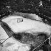
H: The well-preserved remains of a small corn-drying kiln, part of a ditched enclosure and several miscellaneous, relatively modern, cut features were excavated in the area centred NY 1670 7297.
The ditch, first encountered during machine stripping of the topsoil in the field to the east of the excavated area, was roughly 1.25m deep and up to 3m wide. The ditch forms an arc to the north and has presumably been cut by the modern road (B725). The corn-drying kiln was located outside the ditch. It was pear-shaped on pllan and had been cut into
the hillside, its flue aligned to the northeast. The pit, cut into the the sand and gravel subsoil, had been lined with clay and stones and revetted with a wicker hurdle structure, formed of oak stakes and hazel withies. The structure had burned down at least twice and on both occasions was relined with clay and refurbished in timber. A large assemblage of carbonised cereal grain was recovered from the kiln floor. A second corn-drier, of identical type, was located 50m to the east, inside the enclosure.
I: A small subrectangular post-built timber structure was located at NY 1664 7289, just inside the enclosure ditch. A large number of truncated features, comprising post-holes, pits, fence-lines and a hearth, the latter possibly prehistoric in date, were also located in this area.
J: At NY 1667 7286, the remains of a crudely coursed drystone wall were traced at the south edge of the field, coincident with the edge of the terrace. This appears to have been constructed as a revetting wall, to prevent soil creep and inundation of a small stone-lined spring or well which was traced immediately adjacent, on the downslope side of the wall. Waterlogged organic material was recovered from the spring.
C E Lowe 1991
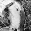
NY 1686 7290. Further work was undertaken by AOC (Scotland) Ltd on the site in November and December 1991 to complete the excavation and recording of an early stone structure which was buried beneath the enclosure bank and a large sunken-feature building which had been set over the infilled ditch which lay adjacent. The stone building was dismantled for future reconstruction and a second Roman inscription was found.
The Post-Ditch Sunken-Feature Building:
The cut for the pit measured 10.7m by 4.4m externally in its eroded state and 1.25m deep, inside which a substantial post-built structure was against the interior basal edge of the pit, set on average 1m to 1.5m apart, to form a sub-rectangular building 8.5m long and 3.2m wide. The remains of a sill-beam acrosss the centre of the building appears to have divided the structure in two. Evidence for timber panelling between the upright posts, either keyed into the posts or set into a sill-beam, is inferred on the basis of the very angular form and extent of the charcoal-rich destruction horizon which extended throughout the building. The finds recovered from this surface, seemingly in situ material associated with the use of the building, consisted principally of lumps of smithing slag and fragments of iron objects. A large fire-box or hearth, set within a deep pit, lay close to the centre of the building. Two sunken entrances into the structure were located;
one at the SW corner of the building, the other in the centre of the S wall. The SW entrance appears to have been covered by a small porch or an extention of the roof.
The Pre-Enlosure Stone Building:
The structure, oriented E-W, was buried beneath the enclosure bank
and comprised both- above and below-ground elements. The subterranean element measured 4.5m by 2.6m within walls 70cm to 80cm wide and 1m upstanding. This part of the building was constructed inside a large subrectangular pit, 6m long, up to 4.25m wide and 1.15m deep, which had been cut through the old ground surface. The base of the pit was paved throughout with large flat slabs of split sandstone, closely fitted together and luted with clay, and it was on this surface that the interior walls were subsequently erected to form a small, sunken subrectangular building. Two short 'wing-walls', up to 1.3m long and of the same width as, and of one build with, the side walls to the N, were erected over the old ground surface. Traces of a return wall, possibly a stone footing for a timber superstructure, were defined along the S.
A series of post- and stake-holes in this aera, however, may suggest that the S side of the building was wholly constructed in timber. The overall dimensions of the building, including the 'wing-walls' and possible S facade, were 6m by 5.4m. A large amount of clay was used in the construction of the building. The walls were founded on a clay skim, overlying the floor slabs. The masonry, constructed of square dressed sandstone blocks, was also clay-bonded. The walls were faced internally, with a rubble and clay fill and, in places, the latter effectively lined the sides of the pit. The masonry of the building is of Roman type and represents robbed material. A second Roman inscription was recovered, built into the W 'wing-wall'. It features the bottom right-hand corner of an inscription, set within a deep border with a small rosette and volutes, in deep relief, to the right of the panel: } VIII AVG } } XXII PR } F. A steep curving passage, 11m long, 1.5m wide and up to 2m deep, was located at the SW corner of the building; it was entered through a narrow, constructed gap in the wall 30cm wide. The paving consisted of large flat slabs and extended beneath the S wall of the overlying building and reoresents a continuation of the paved floor inside. Over the flagged base of the passage was erected a series of large subrectangular stones, set on edge and crudely coursed on those places where the feature wsa best preserved. The sidestones were overlain with thick red clay, free of any inclusions. The primary deposits in the passage comprised charcoal-rich silts with unburnt bone.
Sponsor: Historic Scotland
C E Lowe 1992
Possible 'chapel' located at NY 16678 72900 and classified as 'Dark Age building, possibly ecclesiastical'.
Information from Dr C Lowe, AOC (Scotland) Ltd. 23 January 1992.
Hoddom Church. Listed as monastic enclosure and buildings, inscription and uninscribed building stones (probably from Birrens).
RCAHMS 1997.
Aerial Photographic Transcription (12 February 1991 - 22 February 1991)
An aerial transcription was produced from oblique aerial photographs. RCAHMS 1991
Reference (1997)
NY17SE 56 NY 166 729 - 169 727
Listed as Hoddam, monastic enclosure and buildings.
RCAHMS 1997.
Aerial Photographic Transcription (8 October 2012)
An interpretative transcription, or mapping, of information on oblique aerial photographs was produced on 08 October 2012.

