
Ladyward


Boundary Ditch (Roman), Linear Feature (Period Unknown), Roman Fort (Roman), Roman Road (Roman)
Site Name Ladyward
Classification Boundary Ditch (Roman), Linear Feature (Period Unknown), Roman Fort (Roman), Roman Road (Roman)
Canmore ID 69368
Site Number NY18SW 96
NGR NY 11329 82085
Datum OSGB36 - NGR
Permalink http://canmore.org.uk/site/69368


- Council Dumfries And Galloway
- Parish Dryfesdale
- Former Region Dumfries And Galloway
- Former District Annandale And Eskdale
- Former County Dumfries-shire
NY18SW 96 11329 82085
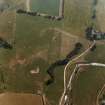
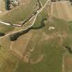
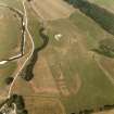
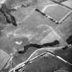
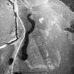
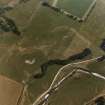
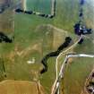
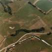
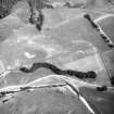
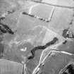
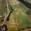
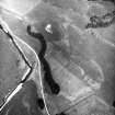
RCAHMS aerial survey has located a fort on the left bank of the Dryfe Water, c.300m above its confluence with the Annan. The site lies c.600m W of the camp at Torwood (NY18SW 11). The fort measures c.180m by at least 110m (c.5 acres) within a system of 5 ditches, whose disposition suggests at least two periods. Erosion by the Dryfe on the NW side has largely destroyed the annexe on that side.
S S Frere 1990
Note (1997)
NY 113 820 NY18SW 96
Listed as temporary camp.
RCAHMS 1997.
Aerial Photographic Transcription (14 February 2011)
Project (2015 - 2018)
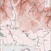
NY 1860 7870 Burnswark; NY 11329 82085 Ladyward; NY 21900 75180 Birrens; NY 21124 75815 Middlebie; NY 1960 7665 Scalewood
RGK commenced a small survey in 2015 in order to investigate relations between indigenous peoples and Romans on the sites of Burnswark and Ladyward from a landscape archaeological perspective. In 2017, RGK continued work in both places and added two further sites. Birrens and Middlebie were therefore included in the research programme for the area, centring on investigations along the line of the Roman road. A third survey in 2018 continued the successful work at Birrens and included nearby Scalewood Castlefield enclosure as a further possible Iron Age site.
In 2015 and 2017 6.6ha were surveyed at Burnswark. In addition to earthworks in the South Camp, accessible areas in the North Camp were examined as well as an area adjacent to the E of the South Camp.
Coherent anthropogenic anomalies inside the camps that could be referred to as contemporary could not be detected with this method in most of the surveyed areas. Both campsites appear to be void of related permanent architecture that can be traced by magnetometry. Only in the area of the ‘Fortlet' in the NE area and in the W area of the South Camp several anthropogenic features could be detected. Moreover, there are indications that an enclosure, exceeding the limits of the South Camp and of trapezoidal shape is also present in the area of the ‘Fortlet'.
In Ladyward the area of the Roman fort, detected in aerial photography in 1990, was surveyed. Next to a further clarification of the inner structures and defences of the fort, linear structures are visible at the base of the ridge.
At Birrens Roman fort, areas N, W and NW of the fort were surveyed. In the W, the annexe of the fort was surveyed with 0.25m sensor distance. The inner structure of the annexe can be identified. NW of the fort a parcelled area was found, dispersed with 23 strongly magnetic anomalies that might indicate hearths or furnaces.
In 2018 the work at Birrens was continued with a quad drawn 14 sensor magnetometry device 0.25m sensor distance, average measuring every 0.15 m. The field W of the fort was completed and new areas S of Mein River were surveyed in the fields of Broadlee Farm. Magnetometry data of 20.8ha in the wider area of Blatobulgium is now available.
West of the township of Middlebie a field was surveyed in 2017, where detectorists had found several Roman metal objects. The line of a Roman road was assumed, and the hope was to trace its course by magnetometry survey. There were no certain indication of structures of roadworks. However, in the centre of the field, clusters of pit-like anomalies refer to anthropogenic activities that would require further investigation.
In the area of Scalewood prehistoric ‘Castlefield enclosure’ situated on the southern flank of Clint Hill 600m NNW of Castlefield cottage was surveyed in 2018. The magnetometry – though badly blurred by very strong magnetic anomalies – at least partly revealed a double-ditch with several interior and outer structures of anthropogenic origin in the SE part of the surveyed area. A circular ditch of 6.5m diameter is visible in the N. The N part of the enclosure is not visible in the magnetometry. The boundary between the two fields containing the enclosure showed a brim, the surface of the S field was up to 0.5m lower than the N area. The abrasion of topsoil in the S field might support the invisibility of the enclosure here.
All gradiometer works of 2015 and 2017 were conducted with a GPS-supported 5-sensor fluxgate GM650B gradiometer device. The survey in 2018 was conducted with the similar technical configuration of 14 sensors mounted on a quad drawn 3m wide rig. Complementary augering was conducted in 2015 Burnswark and Ladyward.
The works are carried out in collaboration with Trimontium Trust Melrose, Archaeology Service - Environmental Planning Dumfries and Galloway Council and Historic Environment Scotland.
Archive: NRHE and Communal Archaeology Dumfries and Galloway
Funder: RGK and Trimontium Trust
Ruth Beusing, John Reid, Axel Posluschny, Nina Dworschak – Römisch-Germanische Kommission, Frankfurt (RGK) of the German Archaeological Institut (Deutsches Archäologisches Institut
(Source: DES Vol 19)
Magnetometry (2015 - 2018)
NY 1860 7870 Burnswark; NY 11329 82085 Ladyward; NY 21900 75180 Birrens; NY 21124 75815 Middlebie; NY 1960 7665 Scalewood
All gradiometer works of 2015 and 2017 were conducted with a GPS-supported 5-sensor fluxgate GM650B gradiometer device. The survey in 2018 was conducted with the similar technical configuration of 14 sensors mounted on a quad drawn 3m wide rig. Complementary augering was conducted in 2015 Burnswark and Ladyward.
The works are carried out in collaboration with Trimontium Trust Melrose, Archaeology Service - Environmental Planning Dumfries and Galloway Council and Historic Environment Scotland
Archive: NRHE and Communal Archaeology Dumfries and Galloway
Funder: RGK and Trimontium Trust
Ruth Beusing, John Reid, Axel Posluschny, Nina Dworschak – Römisch-Germanische Kommission, Frankfurt (RGK) of the German Archaeological Institut (Deutsches Archäologisches Institut
(Source: DES Vol 19)

