
'Dere Street': Border - Newstead - Elginhaugh


Roman Road (Roman)
Site Name 'Dere Street': Border - Newstead - Elginhaugh
Classification Roman Road (Roman)
Canmore ID 68600
Site Number NT62SE 66
NGR NT 6999 2100
NGR Description NT 6999 2100 to NT 6500 2489
Datum OSGB36 - NGR
Permalink http://canmore.org.uk/site/68600


- Council Scottish Borders, The
- Parish Jedburgh
- Former Region Borders
- Former District Roxburgh
- Former County Roxburghshire
NT62SE 66 from 6999 2100 to 6500 2489 RR 2.
Formerly RR 8f.
Descending from sheet edge NT 6999 2100 to the ford over the Oxnam Water (NT 6950 2132) the road is greatly overgrown, but the mound is seen on the NE side of the road and some large-sized bottoming appears at a point where a modern cart-track cuts through the road and crosses it to join the modern road NW of the Cringle Burn. From the ford, Dere Street ran for some 250 yds across the flood-plain of the Oxnam Water in a WNW direction, and then assumed the NW course which it holds in a general way until it disappears at Jedfoot (NT 660 239). It rises by an even, steep slope until the road to Crailinghall is reached (NT 6898 2173). Half way up the slope a stream in the NE side-ditch has eaten into the road-line, revealing natural gravel covered by 5 ins of sandy clay, from above which the road has been entirely removed. A little farther on a small patch of bottoming is, however, preserved. Evidently, the road has been almost completely washed out or worn away on this sandy slope. A well-preserved portion just NW of the road to Crailinghall consists of a flat-topped mound, very slightly dished in the centre by traffic, measuring 31 ft in breadth over all and standing 1 ft above the bottom of a flanking ditch on the SW and 2 ft on the NE. About one-third of the way up the shoulder of Ulston Moor much bottoming is visible, as also on the shoulder itself and again on the next ridge to the NW; the stones are generally large, being 6 in to 8 in in diameter, but smaller packing of 2 in to 3 in in diameter is also to be seen. It is noticeable that at the top of the steep descent to Baittens Burn, where a deep hollow has recently been cut out by tracked vehicles, the remains of the bottoming lie quite close to the surface with natural subsoil below; there were no signs of ancient road-foundations with layers of later metalling super-imposed. The steepest pitch found in this section was 1 in 9'5. On the slope beyond the burn the road is everywhere worn down either to or through the bottoming. This accounts for its flat section. On the summit, however, the causeway appears, half overgrown with whins.
Dere Street continues to be alined between Eildon Mid Hill and Eildon Hill North until it reaches a point about 50 yds NW of the Jedburgh-Crailing road. For the next 250 yds it is alined slightly SW of the summit of Eildon Mid Hill; at a like distance farther again to the NW it has diverged slightly to the SW and aims at the foot of Eildon Wester Hill on its SW side; and on the descent past the corner in the parish boundary towards NT 6688 2334 it swings back to the summit of Eildon Wester Hill. At NT 6688 2334 the direct line of the road is interrupted by the corner of a field which encroaches north-eastwards to the extent of the road's own breadth, and the modern track continues down hill along the NE side of the encroaching field. This displacement is obviously quite a modern feature, dating no doubt from the enclosure of these fields,and it seems very doubtful whether the remaining stretch of 1900 yds of road between this point and Jedfoot (NT 6614 2394) really represents the ancient Dere Street at all. The stone dyke on the SW side of the modern track appears to be largely built of bottoming stones, as if the old road had been entirely torn up following the encroachment. Farther down the hill, however, there is less evidence for the course, which must remain doubtful within about 20 yds to NE or SW.
The stretch of Dere Street extending from the Jedburgh - Crailing road to Jedfoot shows no features materially different from those noted farther SE, and in many places it is a good deal worse preserved. For 150 yds NW of the road a modern corduroy-road covers the Roman metalling.
Beyond the corduroy, metalling appears in the centre of the roadway. On the summit overlooking the Jed Water, the causeway is preserved to a width of 25 ft, though worn down to the bottoming by the traffic-track on the SW side. Where the traffic-track is more deeply worn the mound appears as a more distinctive feature, while elsewhere the whole of the central strip is being worn down to the bottoming, which frequently appears. On the steep descent a deep, fresh cutting discloses on the NE the remains of the bottoming for some 20 yds. The stones lie near the surface and on top of a whitish leached layer. No further remains are to be seen beyond the encroachment mentioned above.
On joining the lane 100 yds S of Jedfoot bridge Dere Street disappears. The course across Jed Water and the haugh between Jed Water and the Teviot is not now evident, but the straight line aims for Nisbetmill Cauld, where there are shoals and islands in the Teviot. That Dere Street made the crossing here is rendered almost certain by its next appearance - some two-thirds of the way up the old ploughed-out avenue, still marked on its eastward side by ancient trees, which once ran from the immediate vicinity of the Cauld to Boggyhall Wood.
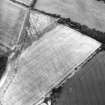
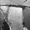
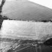
Cultivation now extends right over this avenue, and no certain trace of the road can be detected along its course, but at the point indicated above an unmistakable terrace diverges from it towards the NW; this shortly becomes a low mound, widely spread by ploughing, turning westwards towards the NW corner of the irregularly shaped arable field. No trace of the causeway could be found, and it is likely that all stones have been deliberately removed to facilitate ploughing; nevertheless, there is no doubt as to the true nature of the mound as observed. On the occasion of the visit, the state of the crop made it impossible to follow the roadway right up to the corner; but it would be reasonable to expect that from here it ran to its next point of appearance, NW of the kennels at Woodside (NT 6440 2535), on a course which crossed the Ancrum-Nisbet road some 50 yds E of the Monteviot entrance-gates and thence converged with and finally crossed the avenue leading to the kennels.
Visited 1944-5.
RCAHMS 1956.
NT 6999 2100 - NT 6980 2111 Course runs between modern fences.
NT 6980 2111 - NT 6977 2112 Extant.
NT 6977 2112 - NT 6968 2118 Course runs between modern hedges. Bottoming evident at NT 6968 2118.
NT 6968 2118 - NT 6958 2124 Cart track along and across course of road.
NT 6958 2124 - NT 6947 2134 No trace.
NT 6947 2134 - NT 6906 2165 Course runs between modern fences, possible bottoming at NT 6917 2154.
NT 6906 2165 - NT 6890 2180 Extant.
NT 6890 2180 - NT 6836 2224 Course runs between modern field dykes and/or fences.
NT 6836 2224 - NT 6792 2257 Cart track along course, which runs between modern field dykes and/or fences; bottoming evident at NT 6832 2227.
NT 6792 2257 - NT 6790 2259 ?Extant.
NT 6790 2259 - NT 6704 2321 Cart track along course, which runs between modern field dykes and/or fences.
NT 6704 2321 - NT 6688 2332 Course of road confused by multiple tracks.
NT 6688 2332 - NT 6509 2488 No trace.
NT 6509 2488 - NT 6500 2489 Slight mound; possibly late.
There is no obvious reason for the deviation suggested by RCAHMS between NT 6540 4452 and NT 6440 2535. A straight course cutting sheet edge at NT 6500 2484) could prolong the straight noted earlier and continue the straight noted on NT62NW 46.
Visited by OS (WDJ) January 1967.
Sbc Note
Visibility: This is an upstanding earthwork or monument.
Information from Scottish Borders Council

