
Leadketty


Enclosure (Period Unassigned), Pit(S) (Period Unassigned)
Site Name Leadketty
Classification Enclosure (Period Unassigned), Pit(S) (Period Unassigned)
Canmore ID 68301
Site Number NO01NW 58
NGR NO 01921 15648
Datum OSGB36 - NGR
Permalink http://canmore.org.uk/site/68301


- Council Perth And Kinross
- Parish Dunning
- Former Region Tayside
- Former District Perth And Kinross
- Former County Perthshire
NO01NW 58 01992 15648
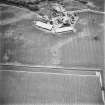
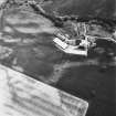
Aerial Photographic Transcription (9 September 1994)
An aerial transcription was produced from oblique aerial photographs. Information from Historic Environment Scotland (BM) 31 March 2017.
Excavation (19 June 2016 - 23 June 2016)
NO 01960 15640 (Canmore ID: 68301) Excavations investigating cropmarks in the southern zone of the Late Neolithic Leadketty palisaded enclosure continued, 19–23 June 2016. In 2015, we excavated a small trench on the edge of the natural escarpment that marks the southern
boundary of the enclosure. This revealed a small timber structure, a large posthole and a series of pits, some of which contained burnt grain and soils (DES 16, 141); these features have mostly returned Late Iron Age dates. The 2016 work was focused 50m to the W, investigating the cropmarks of a putative four-post setting, and linear features. Upon
excavation, it was established that this was not a four-post setting, but rather a grouping of three pits and a single small posthole. The pits each contained a dark brown to black greasy silt clay, cremated bone and charcoal, indicative of rubbish pits associated with a process such as cooking or an industrial activity. The single posthole was relatively modest,
with a lead spindle whorl recovered from the upper fill. The linear cropmarks were shown to be a ditch system, almost certainly post-medieval field boundaries. This eclectic series of features has yet to produce radiocarbon dates, although the pit cluster may relate to the Iron Age activity already uncovered in the same vicinity rather than the Neolithic
enclosure within which it is located.
Archive: HES (intended). Report: HES and SERF website
Funder: HES
Website: www.glasgow.ac.uk/serf
Kenny Brophy – University of Glasgow
(Source: DES, Volume 17)

