
Riccarton Tower


Tower House (Medieval)
Site Name Riccarton Tower
Classification Tower House (Medieval)
Alternative Name(s) O'riccarton
Canmore ID 67993
Site Number NY59NW 5
NGR NY 5440 9580
Datum OSGB36 - NGR
Permalink http://canmore.org.uk/site/67993


- Council Scottish Borders, The
- Parish Castleton
- Former Region Borders
- Former District Roxburgh
- Former County Roxburghshire
NY59NW 5 5440 9580.
See also NY59SW 12
(NY 5440 9580) Riccarton Tower (NR). (Remains of).
OS 6" map (1949)
The site of a tower which is now occupied by a sheep stell. This tower, formerly called 'Rakistonlees', belonged to a branch of the clan Crozier.
J Hardy 1890
Tower symbol near Law's Hill on Pont's map of Liddesdale (1608) probably refers to this tower.
(The identification of the tower called Rakistonlees with Riccarton Tower may be an error - see NY59NE 18).
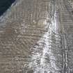
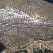
The remains of the tower which has had a sheepfold constructed on its south side measures externally 7.5m N-S by 10.5m transversely between a roughly coursed, mortared wall, 1.5m wide and 2.0m wide, where best preserved on the S side. The entrance is not visible due to the grass- covered N, E and W tumbled walls which also cover the interior. c.30m to the N are two rectangular structures measuring c.15.0m x 6.0m and c.11.0m x 5.0m which were possibly associated with the tower. Name confirmed.
Surveyed at 1:2500.
Visited by OS (JLD) 29 September 1960 and (DWR) 23 March 1972
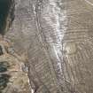
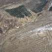
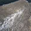
On the E bank of Riccarton Burn, at the foot of a steep and recently afforested hillside are the remains of a small tower or 'pele-house' and its associated buildings. It measures 12.7m from E to W by 9.2m transversely over walls which, with the exception of that on the S, have been reduced to turf-covered mounds of rubble up to 2m high. The S wall is constructed of roughly coursed rubble with some evidence of clay bonding; it is at least 9.3m long externally, 1.4m thick and stands to a height of 2 m; there is a scarcement 1.2m above the present internal ground level. A later sheepfold adjoining the S wall partially overlies what may be an enclosure defined by a low bank.
Situated 15m and 30m N of the tower respectively are two rectangular platforms, each bearing remains of the stone-wall footings of a rectangular building. The first platform has been constructed with its long axis at right angles to the contour and measures 12.2m from E to W by 6.4m transversely, its front scarp is 1.1m high and its rear scarp 0.5m high. The second platform lies parallel to the contour, measures 13.3m from NNW to SSE by 4.2m transversely and has traces of an enclosure on its E side.
A hollow-way which approaches the tower across the hillside from the SSE fades out some 40m distant, and on the slope immediately above the site there are two small quarries.
The remains are probably those of 'O'Riccarton', which is depicted in approximately this position on Ponts Map of Liddesdale (1654), and not 'Rakistonlees' as suggested by Hardy (1889). Nothing appears on Roy's Map at this location (1747-55, sheet 7/1).
Surveyed at 1:10,000
Visited by RCAHMS (PC) March 1985.
Sbc Note
Visibility: Upstanding building, which may not be intact.
Information from Scottish Borders Council

