
Liddel Castle


Earthwork (Period Unassigned), Fortification (Period Unassigned), Motte And Bailey (Medieval)
Site Name Liddel Castle
Classification Earthwork (Period Unassigned), Fortification (Period Unassigned), Motte And Bailey (Medieval)
Alternative Name(s) Liddel Motte; Liddle
Canmore ID 67934
Site Number NY58NW 2
NGR NY 5097 8997
Datum OSGB36 - NGR
Permalink http://canmore.org.uk/site/67934


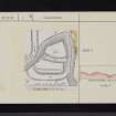
![Publication drawing; Plan of Liddle Castle earthworks, redrawn from Inventory illustration [1912] for publication with comparative plans of mottes and medieval earthwork monuments.](http://i.rcahms.gov.uk/canmore/l/SC00382013.jpg)


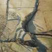
![Publication drawing; Plan of Liddle Castle earthworks, redrawn from Inventory illustration [1912] for publication with comparative plans of mottes and medieval earthwork monuments.](http://i.rcahms.gov.uk/canmore/s/SC00382013.jpg)

- Council Scottish Borders, The
- Parish Castleton
- Former Region Borders
- Former District Roxburgh
- Former County Roxburghshire
NY58NW 2 5097 8997
(NY 5097 8997) Liddel Castle (NR) (Site of)
OS 6" map (1957)
A map in the British Museum, dated 1590, marks 'Castleton' with a tower symbol.
A Jeffrey 1864.
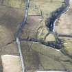
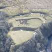
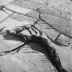
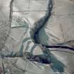
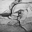
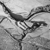
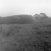
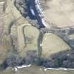
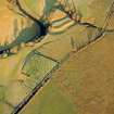
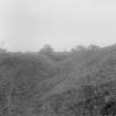
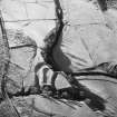
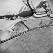
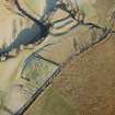
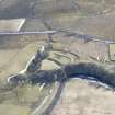
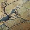
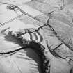
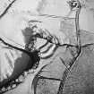
Only the impressive earthworks remains of Liddel Castle, occupying the summit of a bluff, projecting N and bounded on three sides by the Liddle Water and Kirk Cleuch Burn, a tributary. Two parallel ditches have been dug across the headland from flank to flank, leaving two isolated areas, the S one of which has a broad rampart still rising about 6 ft above the interior. The S ditches broad and flat-bottomed, while the N one is narrower. There are now no signs of structures, but in the N section is an oval in which appear a few fairly big stones, and it is reported locally that lower down there is a circular building, evidently a well (published as such on OS 6" 1916 at NY 5097 8999).
Liddel Castle was presumably built by Ranulph de Soules as the caput of the barony granted him by David I (1124-53), whom he accompanied to Scotland. There appear to be no records of it after the early 14th century.
RCAHMS 1956, visited 1931.
The castle earthworks, constructed to a motte and bailey plan, are generally as described and planned by the RCAHMS. The trapezoidal N section has an occupiable area of approximately 200 square metres, and the oblong and sloping S section is about 160 square metres. The substantial dividing ditch is up to 13.0m wide and 4.5m deep on the S side.
The oval feature and stones were not located, but the site of the well survives as a sub-square depression, 0.5m deep.
Surveyed at 1:10,000.
Visited by OS (JRL), 6 August 1979.
Sbc Note
Visibility: This is an upstanding earthwork or monument.
Information from Scottish Borders Council

