 |
On-line Digital Images |
SC 1122858 |
Records of the Royal Commission on the Ancient and Historical Monuments of Scotland (RCAHMS), Edinbu |
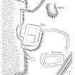
Scanned version of ink drawing DC49401 - Plan of Foulshiels - farmstead/ tower
|
2001 |
Item Level |
|
 |
On-line Digital Images |
SC 1300856 |
Records of the Royal Commission on the Ancient and Historical Monuments of Scotland (RCAHMS), Edinbu |
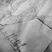
Scanned version of DC49400 - pencil drawing depicting Foulshiels - farmstead/ tower |
1998 |
Item Level |
|
 |
On-line Digital Images |
SC 1761453 |
RCAHMS Aerial Photography |
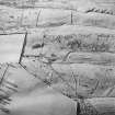
Oblique aerial view of Foulshiels centred on the remains of a farmstead, boundary dykes, pens and lazy-beds, taken from the SE. |
1/12/1997 |
Item Level |
|
 |
On-line Digital Images |
SC 1761454 |
RCAHMS Aerial Photography |
Oblique aerial view of Foulshiels centred on the remains of a farmstead, boundary dykes, pens and lazy-beds, taken from the ESE. |
1/12/1997 |
Item Level |
|
 |
On-line Digital Images |
SC 1761455 |
RCAHMS Aerial Photography |
Oblique aerial view of Foulshiels centred on the remains of a farmstead, boundary dykes, pens and lazy-beds, taken from the E. |
1/12/1997 |
Item Level |
|
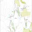 |
On-line Digital Images |
SC 2086546 |
Records of the Royal Commission on the Ancient and Historical Monuments of Scotland (RCAHMS), Edinbu |
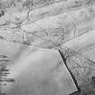
Map showing the archaeological landscape around Foulshiels and Greenshiels, Liddesdale |
2002 |
Item Level |
|
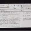 |
On-line Digital Images |
SC 2473152 |
Records of the Ordnance Survey, Southampton, Hampshire, England |
Foulshiels, NY49SE 4, Ordnance Survey index card, page number 1, Recto |
1958 |
Item Level |
|


