|
Prints and Drawings |
DC 33712 PO |
Records of the Royal Commission on the Ancient and Historical Monuments of Scotland (RCAHMS), Edinbu |
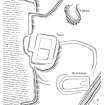
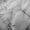
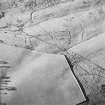
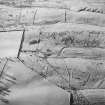
Printout of map showing the archaeological landscape around Foulshiels and Greenshiles, Liddesdale |
1996 |
Item Level |
|
|
Manuscripts |
MS 731/20 |
Records of the Royal Commission on the Ancient and Historical Monuments of Scotland (RCAHMS), Edinbu |
Afforestable Land Survey field database (Liddesdale survey, 1996). Held as attribute table in GIS and in Oracle Field/AP table. Please see DX001442 |
1996 |
Item Level |
|
|
Photographs and Off-line Digital Images |
D 20670 |
RCAHMS Aerial Photography |
Oblique aerial view of Foulshiels centred on the remains of a farmstead, boundary dykes, pens and lazy-beds, taken from the SE. |
1/12/1997 |
Item Level |
|
|
Photographs and Off-line Digital Images |
D 20671 |
RCAHMS Aerial Photography |
Oblique aerial view of Foulshiels centred on the remains of a farmstead, boundary dykes, pens and lazy-beds, taken from the ESE. |
1/12/1997 |
Item Level |
|
|
Photographs and Off-line Digital Images |
D 20672 |
RCAHMS Aerial Photography |
Oblique aerial view of Foulshiels centred on the remains of a farmstead, boundary dykes, pens and lazy-beds, taken from the E. |
1/12/1997 |
Item Level |
|
|
Prints and Drawings |
DC 49400 |
Records of the Royal Commission on the Ancient and Historical Monuments of Scotland (RCAHMS), Edinbu |
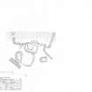
Survey drawing; plan of Foulshiels farmstead/ tower |
4/3/1998 |
Item Level |
|
|
Prints and Drawings |
DC 49401 |
Records of the Royal Commission on the Ancient and Historical Monuments of Scotland (RCAHMS), Edinbu |
Publication drawing; plan of Foulshiels farmstead/ tower |
2000 |
Item Level |
|
 |
On-line Digital Images |
SC 1122858 |
Records of the Royal Commission on the Ancient and Historical Monuments of Scotland (RCAHMS), Edinbu |
Scanned version of ink drawing DC49401 - Plan of Foulshiels - farmstead/ tower
|
2001 |
Item Level |
|
|
Digital Files (Non-image) |
GV 004520 |
Records of the Royal Commission on the Ancient and Historical Monuments of Scotland (RCAHMS), Edinbu |
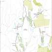
Archaeological landscape map of Foulshiels, Greenshiels area of Liddesdale. Grayscale. Created for Scottish Life and Society publication. |
8/10/2008 |
Item Level |
|
|
Digital Files (Non-image) |
GV 005083 |
Records of the Royal Commission on the Ancient and Historical Monuments of Scotland (RCAHMS), Edinbu |
Digital map (colour) of archaeological landscape around Foulshiels and Greenshiels, Liddesdale in Adobe Illustrator format |
2002 |
Item Level |
|
 |
On-line Digital Images |
SC 1300856 |
Records of the Royal Commission on the Ancient and Historical Monuments of Scotland (RCAHMS), Edinbu |
Scanned version of DC49400 - pencil drawing depicting Foulshiels - farmstead/ tower |
1998 |
Item Level |
|
 |
On-line Digital Images |
SC 1761453 |
RCAHMS Aerial Photography |
Oblique aerial view of Foulshiels centred on the remains of a farmstead, boundary dykes, pens and lazy-beds, taken from the SE. |
1/12/1997 |
Item Level |
|
 |
On-line Digital Images |
SC 1761454 |
RCAHMS Aerial Photography |
Oblique aerial view of Foulshiels centred on the remains of a farmstead, boundary dykes, pens and lazy-beds, taken from the ESE. |
1/12/1997 |
Item Level |
|
 |
On-line Digital Images |
SC 1761455 |
RCAHMS Aerial Photography |
Oblique aerial view of Foulshiels centred on the remains of a farmstead, boundary dykes, pens and lazy-beds, taken from the E. |
1/12/1997 |
Item Level |
|
|
Digital Files (Non-image) |
DX 001442 |
Records of the Royal Commission on the Ancient and Historical Monuments of Scotland (RCAHMS), Edinbu |
RCAHMS Structures Database - Liddesdale survey |
1996 |
Item Level |
|
 |
On-line Digital Images |
SC 2086546 |
Records of the Royal Commission on the Ancient and Historical Monuments of Scotland (RCAHMS), Edinbu |
Map showing the archaeological landscape around Foulshiels and Greenshiels, Liddesdale |
2002 |
Item Level |
|
|
Digital Files (Non-image) |
TM 000559 |
Records of the Royal Commission on the Ancient and Historical Monuments of Scotland (RCAHMS), Edinbu |
Zip file containing all the survey linework collected during the RCAHMS Afforestable Land Survey of Liddesdale |
1996 |
Item Level |
|
 |
On-line Digital Images |
SC 2473152 |
Records of the Ordnance Survey, Southampton, Hampshire, England |
Foulshiels, NY49SE 4, Ordnance Survey index card, page number 1, Recto |
1958 |
Item Level |
|
|
Digital Files (Non-image) |
TM 002203 |
Records of the Royal Commission on the Ancient and Historical Monuments of Scotland (RCAHMS), Edinbu |
Zip file containing all the survey linework collected during the RCAHMS Afforestable Land Survey of Liddesdale. SHP and Geojson file formats with extra attribution added to the linework. |
1996 |
Item Level |
|
|
All Other |
551 166/1/1 |
Records of the Ordnance Survey, Southampton, Hampshire, England |
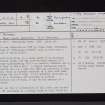
Archaeological site card index ('495' cards) |
1947 |
Sub-Group Level |
|


