
Hermitage Hill, White Dyke


Deer Trap (Medieval), Park Wall (Medieval)
Site Name Hermitage Hill, White Dyke
Classification Deer Trap (Medieval), Park Wall (Medieval)
Canmore ID 67913
Site Number NY49NE 3
NGR NY 4880 9710
NGR Description NY 4880 9710 to NY 5017 9597
Datum OSGB36 - NGR
Permalink http://canmore.org.uk/site/67913


- Council Scottish Borders, The
- Parish Castleton
- Former Region Borders
- Former District Roxburgh
- Former County Roxburghshire
NY49NE 3 486 973 to 5010 9580.
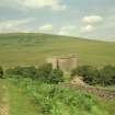
"White Dyke", Hermitage Hill. The remains of a massive drystone wall, locally known as the White Dyke and probably representing the boundary of Hermitage deer-park, extend in a shallow arc across the S face of Hermitage Hill, between the 1000-ft. and 1100-ft. contours, from Coldwell Snab to near a stell some I300 yds. N of Hermitage Castle (RCAHMS 1956, No. 63).
The present length of the work is about 1200 yds., but it must originally have been longer by an unknown amount as stone has been robbed from both ends as well as from various points along its length. The work is in bad preservation, as much of it seems to have been thrown down in preparation for removal; but where least dilapidated it still stands 5 ft. high on a base 4 ft. thick. It is rudely built of large limestone blocks such as occur naturally hereabouts or can be readily quarried from small outcrops; some of the blocks measure as much as 4 ft. by 1 ft. 6 in. or 3 ft. by 2 ft. 3 in. on face, and while the spaces between them are filled up with smaller material, they are not carefully pinned. The general appearance of the masonry is noticeably different from that of the ordinary drystone walls of the district.
RCAHMS 1956, visited 1946.
The following description contains more of the course than described by RCAHMS. The wasted remains of this dyke commences in dense bracken at a point c.120m E of a modern dyke. It runs ENE for c.140m in a low, mutilated condition, and then changes course slightly to run E-W for c.700m to a point c.50m N of a sheepfold. In this part of its course, the dyke attains a height of c.1.2m in places and is 1.1 -1.5m broad at base. From above the fold it becomes more wasted and curves south-eastwards as far as a point c.200m W of a sheepfold on Buckstone Moss (NY 59 NW), and for c.370m its course is defined only as a slight mound running southwards in tussocky grass. From this point near the head of the gully formed by the Green Sike, its course seems to have continued as a ditch with slight upcast bank on the W side. This is traced to the edge of the bluff above the Hermitage Water, c.400m W of Hermitage Farm.
Visited by OS (JLD) 27 September 1960
Field Visit (6 March 1996)
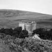
The rough pasture to the N of Hermitage Castle (NY49NE 5) is enclosed by the remains of a park pale, known as the White Dyke, and includes within its compass an open-ended structure that may be a medieval deer-trap.
The possible deer trap comprises two arcs of dyke, which converge over a distance of about 300m from an opening some 600m wide on the W to a gap just 10m across at the E, just short of the Castle. The deer-trap dyke comprises a bank some 0.5m high with an internal ditch, but where the dyke runs down to Lady's Sike from the N, weathering of the ditch has all but removed the bank. The N dyke describes an arc across the gully of the Lady's Sike (NY 4925 9662 to NY 4954 9605), and the S dyke extends from the NW corner of the moated site at Hermitage Chapel (NY49NE 4) along the edge of a terrace above Hermitage Chapel to just short of Hermitage Castle (NY 4955 9604). Together, they form a funnel to trap deer driven off the hill to the W. In a second phase the S dyke was rebuilt with a bank and ditch that extends from the NE corner of the moated site at Hermitage Chapel (NY49NE 4) uphill towards the primary dyke, where it turns a right-angle, to run along the earlier line towards the Castle; in consequence, the profile of the bank in this sector which stands over a metre high in places. The deer-trap was designed for a drive rather than a chase; the dykes providing a narrow overlooked space for a killing-ground.
The rebuilding of the dyke on the S side of the deer trap may be associated with the construction of a large enclosed park of about 114ha, delimited by the White Dyke on the N and E, and the river Hermitage on the S. The position of the W side of the park is uncertain, although a secondary dyke cuts across the area from the White Dyke on the N to the moated site on the S (see below). The White Dyke runs in an arc from Coldwell Snab (NY 4881 9710) on the NW to the head of the Green Sike on the NE, and thence down the E bank of the sike to its lower reaches (NY 5012 9633), where it diverges SSE to the edge of the Hermitage Water (NY 5012 9584), a total distance of 2.5kms. For much of its course the White Dyke is a stone dyke up to about 1m high, but, where it leaves the Green Sike on the S, it becomes a bank and ditch with the ditch on the outside of the enclosure. The W end of the dyke is much dilapidated and disappears in bracken-covered broken ground on the hillslope above the head of the Day Sike, but there is no evidence that it continued down to the sike. The secondary dyke on the W abuts the S side of the White Dyke some 200m from the W end. This dyke, comprising a bank with a ditch on the inside, runs in a straight line from the high ground on the side of Hermitage Hill (NY 4900 9717) to ride over the E spur of Ladys Knowe (NY 4923 9628), cutting through the ridge and furrow on the NE flank of the knowe. At this point it turns slightly to the E to run down to the edge of the terrace above Hermitage Chapel. Here it stops on the N edge of the ditch of the dyke forming the S side of the deer trap, but its line is roughly extended by two banks with a medial ditch that drop down to the corner of the moated site (NY49NE 4). The curious way in which the W end of the White Dyke peters out on the open hill raises several questions to the precise function of the White Dyke and the operation of the Deer Park. Possibly there was a change of plan, which was completed by the insertion of the secondary dyke, but the relationship of this dyke to the rig and furrow on Lady's Knowe may indicate that it is considerably later in date.
The 1st edition OS 6-inch map annotates the area 'Deer Park' (Roxburghshire 1863, sheet xlii), and Hermitage Park is listed in the rental of 1376 under the Forest, suggesting that the area of the park may have been valued as much for its grazing as a deer park (Reg Hon Mort 1853). However, the 1718 estate map which depicts the boundaries of the farm of Hermitage, neither shows the White Dyke nor makes any reference to a deer park, and the boundaries of the farm include an area that is much larger than that enclosed by the White Dyke, and cannot be confused with it (Records of Scotland, RHP 9629). The Braidlie Day Book (Borders Museum Service, Hawick) records the survey and construction of a dyke around Hermitage Park in 1750 and 1752, which provides circumstantial support for the White Dyke being 18th century in date.
Visited by RCAHMS (PJD) 6 March 1996
Reg Hon Mort 1853
Sbc Note (15 April 2016)
Visibility: Standing structure or monument.
Information from Scottish Borders Council

