
Castle Holm


Castle (Medieval), Causeway (Medieval)
Site Name Castle Holm
Classification Castle (Medieval), Causeway (Medieval)
Alternative Name(s) Loch Of Strom; Loch Strom; Castle Strom
Canmore ID 679
Site Number HU34NE 1
NGR HU 39530 47530
Datum OSGB36 - NGR
Permalink http://canmore.org.uk/site/679


- Council Shetland Islands
- Parish Tingwall
- Former Region Shetland Islands Area
- Former District Shetland
- Former County Shetland
Field Visit (31 July 1930)
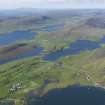
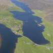
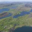
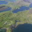
Castle, Loch of Strom.
The islet on which this fragment stands is known as ‘Castle Holm’. It is about 30 yds from the W shore of the S end of the loch and has been connected with it by a causeway, now ruinous and submerged. The castle has been a rectangular tower of rubble, built with shell-lime mortar, and has measured 18 ft. 4 in. from N. to S. by 21 ft. 3 in. from E. to W., over walls from 3 ft. 5 in. to 4 ft. 6 in. thick. At the N.W. angle the remains still rise to a maximum height of 10 ft. Farther E are foundations of other buildings.
This may be the site identified by Russell (Arch. Scot. v, 182) as that of a ‘Brough in Loch of Shurton [Churchton?] on a little holm opposite the church of Whiteness’.
RCAHMS 1946, visited 31 July 1930.
OS 6" map, Shetland, 2nd ed. (1903)
Field Visit (8 June 1968)
The remains of this Castle are as described by the Commission and the causeway, although submerged, can still be crossed at low water. Traces of walling suggest that the island was completely enclosed by a stone wall but no definite traces of any additional buildings were seen.
Surveyed at 1/2500.
Visited by OS (WDJ) 8 June 1968
Desk Based Assessment (1968)
HU34NE 1 3953 4753.
(HU 3952 4733) Castle (GT) (Ruins of) Castle Holm (TI)
OS 6" map, Shetland, 2nd ed. (1903)
The remains of a possible 12th century stone castle stand on an islet in Loch Strom (W D Simpson 1950). The castle measured 18' 4" by 21' 3", over walls from 3' 5" to 4' 6" thick, At the NW angle the remains are still 10' high. Further east are the foundations of other buildings. The islet is connected to the west shore by a causeway, now ruinous and submerged. (Anderson 1873)
RCAHMS 1946
Information from Ordnance Survey Index Card.
Field Visit (19 September 2016)
HU 3953 4753 (HU34NE 1) The Shetland Islets survey intended to examine a range of islet sites including two brochs, a dun and a castle in Shetland. The aim was to gather survey data concerning the nature of the submerged portions of the islets to enable comparison to mainland Scottish crannogs. Castle Holm is located in the brackish, slightly tidal, Strom Loch, Whiteness, and was surveyed on 19 September 2016. The islet is oval shaped extending 20 x 7m above water and 34 x 24m below water. There is a substantial upstanding portion of the castle wall which stands as high 2.2m and is 1.2m thick at it widest point. There is a causeway out to the islet from the nearest shore made up of boulders 0.3–1.0m in diameter. The islet underwater is similarly composed of medium sized boulders, which are not natural accumulations of material. Only excavation would be able to tell whether these boulders were laid down to create the island or are material that has tumbled down from contexts higher up. It was suspected that the medieval castle might be sitting on
an earlier monumental roundhouse site. No evidence for this was found during the survey, but it cannot be ruled out at this stage either.
It was also noted that substantial erosion appears to be taking place on the upstanding masonry. Discussion with the local landowner and a nearby resident revealed that the structure has lost at least 0.5m in height over the past few decades. Photogrammetric survey of the upstanding masonry was carried out to provide a baseline for future quantification of the rate of degradation.
Archive: Shetland Amenity Trust (intended)
Funder: Shetland Amenity Trust
Michael J Stratigos – University of Aberdeen
(Source: DES, Volume 18)

