|
Prints and Drawings |
BD 1/32 |
Records of Historic Scotland, Edinburgh, Scotland |
Kebister survey archive
12 drawings from the 1985-87 survey.
Drawing 1 = 3047: PT Survey 1985, Plane table survey of Areas 1 and 2.
Drawing 2 = 3048: PT Survey 1985, Plan of Feature 7 in Area 4.
Drawing 3 = 3049: PT Survey 1985, Plan of Excavation Areas 1-6.
Drawings 4-5 = 3050: PT Survey 1986, Plan of Castle Strom.
Drawing 6 = 3051: PT Survey 1986, Plan of Castle Strom.
Drawing 7 = 3052: PT Survey 1987, Structure L1, Block L with clearance cairn to S (= Structure 19).
Drawing 8 = 3053: PT Survey 1987, Burnt Mound complex, Block G.
Drawing 9 = 3054: PT Survey 1987, Burnt Mounds, Block H (H1).
Drawing 10 = 3057: Hillside survey.
Drawing 11 = 3058: 1985 Hillside survey with 1987 grid overlay.
Drawing 12 = 3059: Hillside grid for 1987 survey.
|
1985 |
Item Level |
|
 |
On-line Digital Images |
DP 082223 |
RCAHMS Aerial Photography Digital |
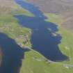
General oblique aerial view of the Loch of Strom, looking NE. |
15/6/2010 |
Item Level |
|
 |
On-line Digital Images |
DP 082225 |
RCAHMS Aerial Photography Digital |
General oblique aerial view of Loch of Strom with Weisdale Voe beyond, looking N. |
15/6/2010 |
Item Level |
|
 |
On-line Digital Images |
DP 082226 |
RCAHMS Aerial Photography Digital |
General oblique aerial view of Loch of Strom with Weisdale Voe beyond, looking N. |
15/6/2010 |
Item Level |
|
 |
On-line Digital Images |
DP 082227 |
RCAHMS Aerial Photography Digital |
General oblique aerial view of Loch of Strom with Weisdale Voe beyond, looking N. |
15/6/2010 |
Item Level |
|
 |
On-line Digital Images |
SC 2337421 |
Records of the Ordnance Survey, Southampton, Hampshire, England |
Castle Holm, HU34NE 1, Ordnance Survey index card, Recto |
1958 |
Item Level |
|
 |
On-line Digital Images |
SC 2337422 |
Records of the Ordnance Survey, Southampton, Hampshire, England |
Castle Holm, HU34NE 1, Ordnance Survey index card, page number 1, Recto |
1958 |
Item Level |
|
 |
On-line Digital Images |
SC 2337423 |
Records of the Ordnance Survey, Southampton, Hampshire, England |
Castle Holm, HU34NE 1, Ordnance Survey index card, Verso |
1958 |
Item Level |
|
|
All Other |
551 166/1/1 |
Records of the Ordnance Survey, Southampton, Hampshire, England |
Archaeological site card index ('495' cards) |
1947 |
Sub-Group Level |
|


