 |
On-line Digital Images |
SC 381994 |
Records of the Royal Commission on the Ancient and Historical Monuments of Scotland (RCAHMS), Edinbu |
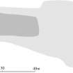
Publication drawing; Plan of Windy Edge chambered long cairn. |
1996 |
Item Level |
|
 |
On-line Digital Images |
SC 381995 |
Records of the Royal Commission on the Ancient and Historical Monuments of Scotland (RCAHMS), Edinbu |
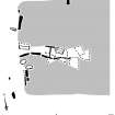
Publication drawing; Detail of chamber of Windy Edge chambered long cairn. |
1996 |
Item Level |
|
 |
On-line Digital Images |
SC 1352970 |
Records of the Royal Commission on the Ancient and Historical Monuments of Scotland (RCAHMS), Edinbu |
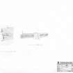
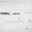
Survey drawing; Plan of Windy Edge chambered cairn and detail of chamber. |
29/6/1993 |
Item Level |
|
 |
On-line Digital Images |
SC 1917584 |
Records of the Royal Commission on the Ancient and Historical Monuments of Scotland (RCAHMS), Edinbu |
Map showing the distribution of stone axes and Neolithic monuments (long cairns, bank barrow, standing stones, cursus, stone circles, henges and pitted enclosures) in Annandale and Eskdale. Published in Eastern Dumfriesshire: an archaeological landscape. |
1996 |
Item Level |
|
 |
On-line Digital Images |
SC 1917635 |
Records of the Royal Commission on the Ancient and Historical Monuments of Scotland (RCAHMS), Edinbu |
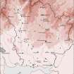
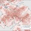
This map shows the distribution of Neolithic funerary monuments in southern Scotland and northern England. In the eastern part of the country these tend to comprise long cairns and borrows scattered around the edges of the river catchments, whereas in the west there is much greater architectural variety: and the monuments form marked clusters. Published in Eastern Dumfriesshire: an archaeological landscape. |
1996 |
Item Level |
|
 |
On-line Digital Images |
DP 380575 |
Records of the Royal Commission on the Ancient and Historical Monuments of Scotland (RCAHMS), Edinbu |
Publication drawing; plan of chambered cairn, cairns and standing stones, Windy Edge (RCAHMS 1920, fig. 29)
|
4/6/1920 |
Item Level |
|
 |
On-line Digital Images |
DP 380577 |
Records of the Royal Commission on the Ancient and Historical Monuments of Scotland (RCAHMS), Edinbu |
Survey drawing; chambered cairn, cairns and standing stones, Windy Edge
|
4/6/1920 |
Item Level |
|
 |
On-line Digital Images |
SC 2473093 |
Records of the Ordnance Survey, Southampton, Hampshire, England |
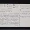
Windy Edge, NY48SW 1, Ordnance Survey index card, Recto |
1958 |
Item Level |
|
 |
On-line Digital Images |
SC 2473094 |
Records of the Ordnance Survey, Southampton, Hampshire, England |
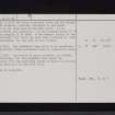
Windy Edge, NY48SW 1, Ordnance Survey index card, page number 1, Recto |
1958 |
Item Level |
|
 |
On-line Digital Images |
SC 2473095 |
Records of the Ordnance Survey, Southampton, Hampshire, England |
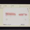
Windy Edge, NY48SW 1, Ordnance Survey index card, page number 2, Verso |
1958 |
Item Level |
|
 |
On-line Digital Images |
SC 2473096 |
Records of the Ordnance Survey, Southampton, Hampshire, England |
Windy Edge, NY48SW 1, Ordnance Survey index card, page number 1, Recto |
1958 |
Item Level |
|
 |
On-line Digital Images |
SC 2473097 |
Records of the Ordnance Survey, Southampton, Hampshire, England |
Windy Edge, NY48SW 1, Ordnance Survey index card, page number 2, Verso |
1958 |
Item Level |
|
 |
On-line Digital Images |
SC 2473098 |
Records of the Ordnance Survey, Southampton, Hampshire, England |
Windy Edge, NY48SW 1, Ordnance Survey index card, Recto |
1958 |
Item Level |
|
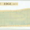 |
On-line Digital Images |
DP 407766 |
Audrey S Henshall |
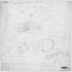
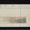
Plan of chambered cairn (DMF 4) on graph paper |
1956 |
Item Level |
|


