 |
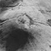
On-line Digital Images |
SC 1761496 |
RCAHMS Aerial Photography |
Oblique aerial view centred on the remains of the cairn and possible plantation bank, taken from the NNE. |
27/3/2000 |
Item Level |
|
 |
On-line Digital Images |
SC 1761497 |
RCAHMS Aerial Photography |
Oblique aerial view centred on the remains of the cairn and possible plantation bank, taken from the NW. |
27/3/2000 |
Item Level |
|
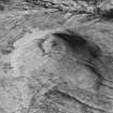 |
On-line Digital Images |
SC 1761498 |
RCAHMS Aerial Photography |
Oblique aerial view centred on the remains of the cairn and possible plantation bank, taken from the SW. |
27/3/2000 |
Item Level |
|
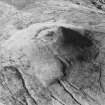 |
On-line Digital Images |
SC 1761499 |
RCAHMS Aerial Photography |
Oblique aerial view centred on the remains of the cairn and possible plantation bank, taken from the SSE. |
27/3/2000 |
Item Level |
|
 |
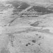
On-line Digital Images |
SC 1761504 |
RCAHMS Aerial Photography |
Oblique aerial view. |
1980 |
Item Level |
|
 |
On-line Digital Images |
SC 1761505 |
RCAHMS Aerial Photography |
Oblique aerial view. |
1980 |
Item Level |
|
 |
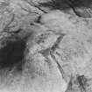
On-line Digital Images |
SC 2473060 |
Records of the Ordnance Survey, Southampton, Hampshire, England |
Tinnis Hill, NY48NW 1, Ordnance Survey index card, Recto |
1958 |
Item Level |
|
 |
On-line Digital Images |
SC 2473061 |
Records of the Ordnance Survey, Southampton, Hampshire, England |
Tinnis Hill, NY48NW 1, Ordnance Survey index card, page number 1, Recto |
1958 |
Item Level |
|
 |
On-line Digital Images |
SC 2473062 |
Records of the Ordnance Survey, Southampton, Hampshire, England |
Tinnis Hill, NY48NW 1, Ordnance Survey index card, page number 2, Verso |
1958 |
Item Level |
|


