
Cadgill


Cursus (Neolithic)(Possible)
Site Name Cadgill
Classification Cursus (Neolithic)(Possible)
Alternative Name(s) Cadgill House; Half Morton Church; Timpanheck Cottage; Cadgill Burn
Canmore ID 67561
Site Number NY37SW 18
NGR NY 31785 74536
NGR Description NY 3170 7459 to NY 3185 7448
Datum OSGB36 - NGR
Permalink http://canmore.org.uk/site/67561


- Council Dumfries And Galloway
- Parish Half Morton
- Former Region Dumfries And Galloway
- Former District Annandale And Eskdale
- Former County Dumfries-shire
NY37SW 18 3170 7459 to 3185 7448
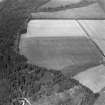
(Classified as linear cropmarks: location cited as NY 317 745 to 318 744). Air photography has revealed the cropmarks of two parallel ditches (measuring 140m in length and set 15m apart) which cross an arable field 250m WNW of Half Morton parish church (NY37SW 24) from NW to SE; at the SE end a third stretch of ditch links the other two at right angles. They may have enclosed a recent shelter belt; there is nothing to be seen on the ground.
RCAHMS 1981, visited March 1981.
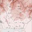
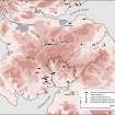
This possible cursus is plotted on a distribution map of Neolithic monuments covering southern Scotland (RCAHMS 1997, 115, fig. 110).
Information from RCAHMS (ARG), 7 April 1998
Scheduled as 'Timpenheck Cottage, cursus 340m WNW of... the cropmarked remains of a cursus monument... in a cultivated field east of the Cadgill Burn... at 80m above sea level,'
Information from Historic Scotland, scheduling document dated 1 October 2007.
Field Visit (March 1981)
Timpanheck NY 317 745 to 318 744 NY37SW
Air photography has revealed the cropmarks of two parallel ditches (140m in length and 15m apart) which cross an arable field 250m WNW of Half Morton parish church from NW to SE; at the SE end a third stretch of ditch links the other two at right angles. They may have enclosed a recent shelter belt.
RCAHMS 1981, visited March 1981
Aerial Photographic Transcription (18 February 1993 - 2 March 1993)
An aerial transcription was produced from oblique aerial photographs. Information from Historic Environment Scotland (BM) 31 March 2017.
Field Visit (28 November 1995)
NY 3170 7459 to 3185 7448 NY37SW 18
Air photography (John Dewar 1975) has recorded the cropmarks of what is possibly a ditched cursus extending across a level field 300m N of Cadgill House and 200m WSW of Half Morton parish church (NY37SW 22 and 24 respectively). The ditches are set about 17m apart and can be traced on the aerial photographs for a distance of at least 180m WNW from a squared terminal on the edge of a shallow stream gully on the S side of the field. The S angle of the terminal is obscured by a wet mark and a drain in the field. While it is impossible to be certain that the side-ditches are any more than drains, the presence of the terminal suggests that it should be considered as a possible example of a cursus. Its level position is also comparable to other pitted and ditched cursuses that have been recorded as cropmarks, although these are usually situated on gravel terraces in the bottoms of valleys.
Visited by RCAHMS (SPH, ARG), 28 November 1995.
Listed as cursus (possible).
RCAHMS 1997.
Aerial Photographic Transcription (8 November 2012)
An interpretative transcription, or mapping, of information on oblique aerial photographs was produced on 08 November 2012.

