
Gilnockie Castle


Earthwork (Medieval)
Site Name Gilnockie Castle
Classification Earthwork (Medieval)
Canmore ID 67519
Site Number NY37NE 4
NGR NY 38634 78208
Datum OSGB36 - NGR
Permalink http://canmore.org.uk/site/67519


- Council Dumfries And Galloway
- Parish Canonbie
- Former Region Dumfries And Galloway
- Former District Annandale And Eskdale
- Former County Dumfries-shire
NY37NE 4 3862 7821
(NY 3862 7821) Gilnockie Castle (NR)
(Site of)
OS 6" map (1957)
Earthworks which suggest a promontory fort of familiar type.
Source: RCAHMS 1920
The name 'Gilnockie Castle' seems to have been applied here because of the opinion held by some authorities, and disputed by others, that Johnnie Armstrong of Gilnockie had a tower at the E end of Gilnockie Bridge, possibly the predecessor of that noted on NY37NE 3. At the same time the Armstrong clan were responsible for the building of many of the border towers in the debatable lands, and on a small scale map of 1590 a tower is shown at 'ye Thornwhate'. Nether Thorniewhats is at NY 389 784. It is not known it there is any connection between 'ye Thornwhate' tower and the site E of Gilnockie Bridge.
Source: J and R Hyslop 1912
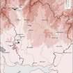
Situated on a promontory in a bend on the River Esk are the remains of a small fort measuring about 40.0m NE-SW by 36.0m transversley. It consists of a substantial earth and stone rampart with a causewayed entrance in the centre. The remaining sides are protected by the steep natural slopes to the river. The S side of the fort and the rampart and ditch have been mutilated by modern tracks and road. The interior has been quarried and there is no trace of any tower. The site is still known as 'Gilnockie Castle'. There is no trace of a tower at Nether Thorniewhats.
Resurveyed at 1:2500.
Visited by OS (RD) 21 December 1970
No change to the previous report.
Visited by OS (JP) 20 February 1973
Field Visit (27 March 1915)
Mound and Ditch, Gilnockie Bridge.
At the east end of Gilnockie Bridge is a high mound running from the road in a northerly direction. Midway there is an entrance, and a fosse runs parallel to the whole front. The inner scarp of the mound has been faced with stones. The enclosure so cut off is a promontory with precipitous sides to the river and narrowing just in the line of mound and ditch. The prolongation of these to the south bank has been destroyed in making the road at. a lower level, but the construction clearly suggests a promontory fort of familiar type. The O.S. map indicates ‘Gilnockie Castle (site)’ E. of No. 50.
RCAHMS 1920, visited 27 March 1915
OS 6” map liii.SE (‘Moat’)
Field Visit (December 1980)
Gilnockie Castle NY 386 782 NY37NE 4
This medieval earthwork is situated on a promontory overlooking the River Esk at the E end of Gilnockie Bridge. A bank (7.5m thick and 1.8m high) and external ditch cut off the neck of the promontory and defend an area measuring 61m by 36m. The interior has been extensively quarried and is crossed by the public road (A7).
RCAHMS 1981, visited December 1980
(RCAHMS 1920, p. 30, No. 50)
Note (1997)
NY 3862 7821 NY37NE 4
Listed as earthwork (castle, possible).
RCAHMS 1997.
Management (26 March 2008)
Scheduled as 'Gilnockie Castle, earthwork NE of Gilnockie Bridge... the remains of an earthwork, probably of later medieval date, surviving as a bank and ditch cutting off a promontory in a bend of the River Esk [and] located in mature deciduous woodland.'
Information from Historic Scotland, scheduling document dated 26 March 2008.
Note (3 July 2014 - 23 May 2016)
This promontory work occupies the bluff overlooking the E end of Gilknockie Bridge and in the early 20th century was believed by some in the locality to be the site of a tower constructed by Johnny Armstrong of Gilknockie (Hyslop and Hyslop 1912, 350-1). While there is no evidence of a tower at this location, which has been heavily disturbed by quarrying and the roads and tracks approaching the bridge, a massive earthwork has been drawn across the neck of the promontory on the ENE, comprising an earthen rampart 7.5m in thickness by 1.8m in height with a broad external ditch. The triangular interior, which falls away precipitously on the NW and S, measures 61m from NE to SW by a maximum of 36m transversely (0.1ha) immediately to the rear of the rampart. Midway along the rampart there is an entrance with a corresponding causeway across the ditch. The character of the visible earthworks suggests that this is probably a medieval castle and it may have been the caput of the barony of 'Bryntallone' or 'Bretallach', which became redundant when its lands were granted to the priory of Canonbie (RCAHMS 1997, 196).
Information from An Atlas of Hillforts of Great Britain and Ireland – 23 May 2016. Atlas of Hillforts SC1122

