 |
On-line Digital Images |
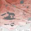
SC 1917378 |
Records of the Royal Commission on the Ancient and Historical Monuments of Scotland (RCAHMS), Edinbu |
Solway Plain landscape case-study area: map showing the distribution of prehistoric monuments and artefacts, and the Roman monuments. Published in Eastern Dumfriesshire: an archaeological landscape. |
1996 |
Item Level |
|
 |
On-line Digital Images |
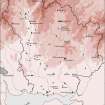
SC 1917584 |
Records of the Royal Commission on the Ancient and Historical Monuments of Scotland (RCAHMS), Edinbu |
Map showing the distribution of stone axes and Neolithic monuments (long cairns, bank barrow, standing stones, cursus, stone circles, henges and pitted enclosures) in Annandale and Eskdale. Published in Eastern Dumfriesshire: an archaeological landscape. |
1996 |
Item Level |
|
 |
On-line Digital Images |
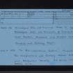
SC 2472257 |
Records of the Ordnance Survey, Southampton, Hampshire, England |
Lochmaben Stone, NY36NW 25, Ordnance Survey index card, Recto |
1958 |
Item Level |
|
 |
On-line Digital Images |
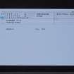
SC 2472258 |
Records of the Ordnance Survey, Southampton, Hampshire, England |
Lochmaben Stone, NY36NW 25, Ordnance Survey index card, Recto |
1958 |
Item Level |
|
 |
On-line Digital Images |
SC 2472259 |
Records of the Ordnance Survey, Southampton, Hampshire, England |
Lochmaben Stone, NY36NW 25, Ordnance Survey index card, page number 1, Recto |
1958 |
Item Level |
|
 |
On-line Digital Images |
SC 2472260 |
Records of the Ordnance Survey, Southampton, Hampshire, England |
Lochmaben Stone, NY36NW 25, Ordnance Survey index card, page number 2, Verso |
1958 |
Item Level |
|
 |
On-line Digital Images |
SC 2472261 |
Records of the Ordnance Survey, Southampton, Hampshire, England |
Lochmaben Stone, NY36NW 25, Ordnance Survey index card, Recto |
1958 |
Item Level |
|
 |
On-line Digital Images |
SC 2506361 |
|
|
1970 |
Item Level |
|
 |
On-line Digital Images |
SC 2506362 |
|
|
1970 |
Item Level |
|
 |
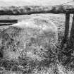
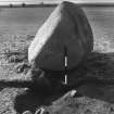
On-line Digital Images |
SC 2506414 |
|
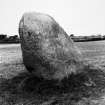
Photograph of the Lochmaben Stone. |
|
Item Level |
|
 |
On-line Digital Images |
SC 2506430 |
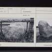
Central Excavation Unit |
Excavation photograph |
|
Item Level |
|
 |
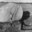
On-line Digital Images |
SC 2506431 |
Central Excavation Unit |
Excavation photograph |
|
Item Level |
|
 |
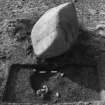
On-line Digital Images |
SC 2506432 |
Central Excavation Unit |
Excavation photograph |
|
Item Level |
|
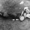 |
On-line Digital Images |
SC 2506433 |
Central Excavation Unit |
Excavation photograph |
|
Item Level |
|
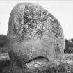 |
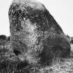
On-line Digital Images |
SC 2506471 |
Records of the Royal Commission on the Ancient and Historical Monuments of Scotland (RCAHMS), Edinbu |
Photograph of the Lochmaben Stone. |
1912 |
Item Level |
|


