 |
On-line Digital Images |
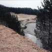
SC 381662 |
|
CROPPED IMAGE |
|
Item Level |
|
 |
On-line Digital Images |
SC 381986 |
Records of the Royal Commission on the Ancient and Historical Monuments of Scotland (RCAHMS), Edinbu |
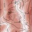
Publication drawing; Over Rig, enclosure. Scanned image of ink drawing. |
2/3/1995 |
Item Level |
|
 |
On-line Digital Images |
SC 383462 |
|
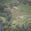
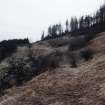
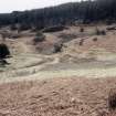
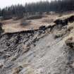
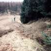
Over Rig, enclosure (possibly ritual). |
|
Item Level |
|
 |
On-line Digital Images |
SC 1352968 |
Records of the Royal Commission on the Ancient and Historical Monuments of Scotland (RCAHMS), Edinbu |
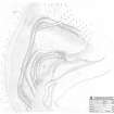
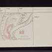
Survey drawing; Plan of Over Rig, enclosure. |
14/6/1993 |
Item Level |
|
 |
On-line Digital Images |
DP 264047 |
Historic Environment Scotland |
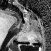
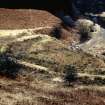
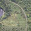
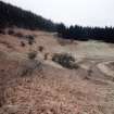
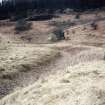
Oblique aerial view. |
29/8/2017 |
Item Level |
|
 |
On-line Digital Images |
DP 264048 |
Historic Environment Scotland |
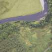
Oblique aerial view. |
29/8/2017 |
Item Level |
|
 |
On-line Digital Images |
DP 264049 |
Historic Environment Scotland |
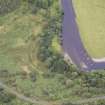
Oblique aerial view. |
29/8/2017 |
Item Level |
|
 |
On-line Digital Images |
DP 264050 |
Historic Environment Scotland |
Oblique aerial view. |
29/8/2017 |
Item Level |
|
 |
On-line Digital Images |
DP 264051 |
Historic Environment Scotland |
Oblique aerial view. |
29/8/2017 |
Item Level |
|
 |
On-line Digital Images |
SC 1761172 |
RCAHMS Aerial Photography |
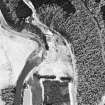
Oblique aerial view. |
1980 |
Item Level |
|
 |
On-line Digital Images |
SC 1917406 |
Records of the Royal Commission on the Ancient and Historical Monuments of Scotland (RCAHMS), Edinbu |
Column-width map showing the extent of the system of linear earthworks around the fort at Castle O'er. Published in Eastern Dumfriesshire: an archaeological landscape. |
1996 |
Item Level |
|
 |
On-line Digital Images |
SC 2472118 |
Records of the Ordnance Survey, Southampton, Hampshire, England |
Over Rig, NY29SW 8, Ordnance Survey index card, page number 1, Recto |
1958 |
Item Level |
|
 |
On-line Digital Images |
SC 2472119 |
Records of the Ordnance Survey, Southampton, Hampshire, England |
Over Rig, NY29SW 8, Ordnance Survey index card, page number 2, Verso |
1958 |
Item Level |
|
 |
On-line Digital Images |
SC 2472120 |
Records of the Ordnance Survey, Southampton, Hampshire, England |
Over Rig, NY29SW 8, Ordnance Survey index card, page number 3, Recto |
1958 |
Item Level |
|
 |
On-line Digital Images |
SC 2472121 |
Records of the Ordnance Survey, Southampton, Hampshire, England |
Over Rig, NY29SW 8, Ordnance Survey index card, Recto |
1958 |
Item Level |
|
 |
On-line Digital Images |
SC 2472122 |
Records of the Ordnance Survey, Southampton, Hampshire, England |
Over Rig, NY29SW 8, Ordnance Survey index card, Recto |
1958 |
Item Level |
|
 |
On-line Digital Images |
SC 2506395 |
|
|
1984 |
Item Level |
|
 |
On-line Digital Images |
SC 2506396 |
|
|
1984 |
Item Level |
|
 |
On-line Digital Images |
SC 2506399 |
|
|
1984 |
Item Level |
|
 |
On-line Digital Images |
SC 2506400 |
|
|
1984 |
Item Level |
|
 |
On-line Digital Images |
SC 2506401 |
|
|
1984 |
Item Level |
|
 |
On-line Digital Images |
SC 2506408 |
|
|
1984 |
Item Level |
|
 |
On-line Digital Images |
SC 2506409 |
|
|
1984 |
Item Level |
|
 |
On-line Digital Images |
SC 2506410 |
|
|
1984 |
Item Level |
|


