 |
On-line Digital Images |
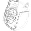
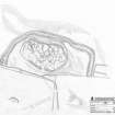
SC 372195 |
Records of the Royal Commission on the Ancient and Historical Monuments of Scotland (RCAHMS), Edinbu |
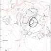
Publication drawing; Plan of fort and other structures on Camp Hill, Bailiehill. |
1996 |
Item Level |
|
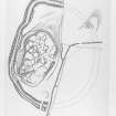
![Map of archaeological features in the landscape around Bailiehill: publication drawing for Inventory of Eastern Dumfriesshire, generated from computer file 5BAILHIL.ai. Unattributed, [1996].](//i.rcahms.gov.uk/canmore/s/SC00372196.jpg) |
On-line Digital Images |
SC 372196 |
|
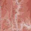
Map of archaeological features in the landscape around Bailiehill: publication drawing for Inventory of Eastern Dumfriesshire, generated from computer file 5BAILHIL.ai. Unattributed, [1996]. |
|
Item Level |
|
 |
On-line Digital Images |
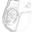
SC 381982 |
Records of the Royal Commission on the Ancient and Historical Monuments of Scotland (RCAHMS), Edinbu |
Publication drawing; Plan of fort and other structures on Camp Hill, Bailiehill. |
1996 |
Item Level |
|
 |
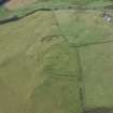
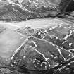
On-line Digital Images |
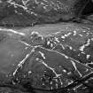
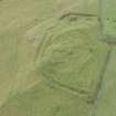
SC 624021 |
RCAHMS Aerial Photography |
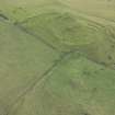
Camp Hill, Bailiehill, oblique aerial view, taken from the ESE, centred on a fort and settlement and on an enclosure and cultivation remains. Bailiehill farmstead is visible in the bottom centre of the photograph. |
14/2/1996 |
Item Level |
|
 |
On-line Digital Images |
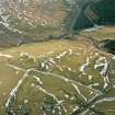
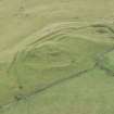
SC 1102692 |
RCAHMS Aerial Photography |
Camp Hill, Bailiehill, oblique aerial view, taken from the ESE, centred on a fort and settlement and on an enclosure and cultivation remains. |
14/2/1996 |
Item Level |
|
 |
On-line Digital Images |
SC 1352379 |
Records of the Royal Commission on the Ancient and Historical Monuments of Scotland (RCAHMS), Edinbu |
Survey drawing; Plan of Bailiehill fort and settlement. |
14/8/1991 |
Item Level |
|
 |
On-line Digital Images |
SC 1388874 |
Records of the Royal Commission on the Ancient and Historical Monuments of Scotland (RCAHMS), Edinbu |
Publication drawing; Plan of fort and other structures on Camp Hill, Bailiehill. |
1996 |
Item Level |
|
 |
On-line Digital Images |
DP 264089 |
Historic Environment Scotland |
Oblique aerial view. |
29/8/2017 |
Item Level |
|
 |
On-line Digital Images |
DP 264090 |
Historic Environment Scotland |
Oblique aerial view. |
29/8/2017 |
Item Level |
|
 |
On-line Digital Images |
DP 264093 |
Historic Environment Scotland |
Oblique aerial view. |
29/8/2017 |
Item Level |
|
 |
On-line Digital Images |
DP 264095 |
Historic Environment Scotland |
Oblique aerial view. |
29/8/2017 |
Item Level |
|
 |
On-line Digital Images |
DP 264097 |
Historic Environment Scotland |
Oblique aerial view. |
29/8/2017 |
Item Level |
|
 |
On-line Digital Images |
DP 264099 |
Historic Environment Scotland |
Oblique aerial view. |
29/8/2017 |
Item Level |
|
 |
On-line Digital Images |
DP 264100 |
Historic Environment Scotland |
Oblique aerial view. |
29/8/2017 |
Item Level |
|
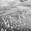 |
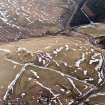
On-line Digital Images |
SC 1761137 |
RCAHMS Aerial Photography |
Camp Hill, Bailiehill, oblique aerial view, taken from the NW, centred on a fort and settlement and on an enclosure and cultivation remains. Bailiehill farmstead and an 'enclosure' and cultivation remains are visible in the top half of the photograph. |
14/2/1996 |
Item Level |
|
 |
On-line Digital Images |
SC 1761138 |
RCAHMS Aerial Photography |
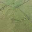
Camp Hill, Bailiehill, oblique aerial view, taken from the NW, centred on a fort and settlement and on an enclosure and cultivation remains. Bailiehill farmstead is visible in the centre top half of the photograph. |
14/2/1996 |
Item Level |
|
 |
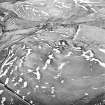
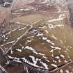
On-line Digital Images |
SC 1761139 |
RCAHMS Aerial Photography |
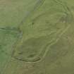
Camp Hill, Bailiehill, oblique aerial view, taken from the SE, centred on a fort and settlement and on an enclosure and cultivation remains. Bailiehill farmstead is visible in the bottom right-hand corner of the photograph. |
14/2/1996 |
Item Level |
|
 |
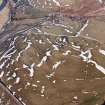
On-line Digital Images |
SC 1761140 |
RCAHMS Aerial Photography |
Camp Hill, Bailiehill, oblique aerial view, taken from the ESE, centred on a fort and settlement and on an enclosure and cultivation remains. Bailiehill farmstead is visible in the bottom centre of the photograph. |
14/2/1996 |
Item Level |
|
 |
On-line Digital Images |
SC 1761160 |
RCAHMS Aerial Photography |
Camp Hill, Bailiehill, oblique aerial view, taken from the ESE, centred on a fort and settlement and on an enclosure and cultivation remains. |
14/2/1996 |
Item Level |
|
 |
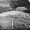
On-line Digital Images |
SC 1761161 |
|
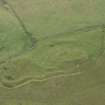
Camp Hill, Bailiehill, oblique aerial view, taken from the NNE, centred on a fort and settlement and on an enclosure and cultivation remains. Bailiehill farmstead and an 'enclosure' and cultivation remains are visible in the top left-hand corner of the photograph. |
14/2/1996 |
Item Level |
|
 |
On-line Digital Images |
SC 1761162 |
|
Camp Hill, Bailiehill, oblique aerial view, taken from the NW, centred on a fort and settlement and on an enclosure and cultivation remains. Bailiehill farmstead is visible in the centre top half of the photograph. |
14/2/1996 |
Item Level |
|
 |
On-line Digital Images |
SC 1917405 |
Records of the Royal Commission on the Ancient and Historical Monuments of Scotland (RCAHMS), Edinbu |
Upper Eskdale landscape case-study area: map showing the prehistoric monuments, with windows for maps of Bailiehill and Raeburnfoot. Published in Eastern Dumfriesshire: an archaeological landscape. |
11/1996 |
Item Level |
|
 |
On-line Digital Images |
SC 1917418 |
Records of the Royal Commission on the Ancient and Historical Monuments of Scotland (RCAHMS), Edinbu |
Map of archaeological features in the landscape around Bailiehill: Published in Eastern Dumfriesshire: an archaeological landscape. |
1996 |
Item Level |
|
 |
On-line Digital Images |
SC 2471929 |
Records of the Ordnance Survey, Southampton, Hampshire, England |
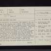
Camp Hill, Bailiehill, NY29SE 8, Ordnance Survey index card, page number 1, Recto |
1958 |
Item Level |
|


