
Learable Hill


Stone Row (Neolithic) - (Bronze Age)
Site Name Learable Hill
Classification Stone Row (Neolithic) - (Bronze Age)
Canmore ID 6718
Site Number NC82SE 6
NGR NC 892 235
NGR Description NC 8924 2355 and NC 8932 2349
Datum OSGB36 - NGR
Permalink http://canmore.org.uk/site/6718


- Council Highland
- Parish Kildonan
- Former Region Highland
- Former District Sutherland
- Former County Sutherland
NC82SE 6 892 235.
(NC 8924 2355 & NC 8932 2349) Stone Rows (NR)
OS 6"map, (1962)
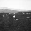
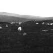
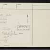
Two sets of stone rows, one running E-W and the other NW-SE. The stones are set in parallel rows, mostly facing along the line of row, and are 1 ft to 2 ft in height. They are generally angular slabs of schistose rock. The rows are 4 ft to 5 ft apart and the stones 6 ft to 7 ft apart. Many small mounds occur, sometimes laid across the line of the stone, breaking the continuity of the rows but not apparently forming bases from which they radiate.
RCAHMS 1911, visited 1909; J Anderson 1886
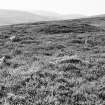
The stone rows, as described by the RCAHMS, are both incomplete, the more westerly being the better preserved. The rows of the latter are interrupted by later stone clearance heaps (See NC82SE 16). The situation is on a prominent spur of Learable Hill.
Visited by OS (J B) 20 January 1977 and (W D J) 29 May 1961
Field Visit (6 June 1991)
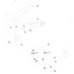
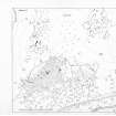
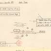
Situated on the peat-covered SE spur of Learable Hill amongst a scatter of small cairns (NC82SE 16), there are four groups of stone rows and what may be a setting of standing stones; two of the groups of stone rows lie to the S and E of a cross-incised standing-stone (NC82SE 1) and a cairn (NC82SE 9), while the remaining monuments occupy higher ground to the N. None of the rows appears to be complete; few of the surviving stones stand more than 0.4m in height and many barely protrude more than 0.1m above the peat.
The southernmost group at NC 8926 2344 comprises six rows of stones, some 22m in length, set in a fan-shaped arrangement with the apex of the fan to the NNW, pointing to the brow of the spur.
The second group lies to the ESE of the standing stone (NC82SE 1) at NC 8928 2347 and comprises three parallel rows of stones, aligned WNW-ESE and 12m in maximum length.
Of the two groups to the N of the cairn (NC82SE 9), the northernmost group extends for a distance of some 80m from NC 8922 2353 to NC 8929 2357, and comprises two parallel rows of stones, aligned roughly NE-SW with, at the W end, a large orthostat (0.8m high and 0.9m by 0.4m at the base).
To the S of this group at NC 8922 2352 there are two parallel rows of stones, aligned E-W and measuring 38m in length overall. They are accompanied on the NE by three shorter rows which may have extended further to the W, but their possible course is now obscured by a line of small cairns.
Between this group and the cairn (NC82SE 9) is a setting of upright stones, but their purpose is uncertain.
Visited by RCAHMS (PJD) 6 June 1991.

