|
Photographs and Off-line Digital Images |
DC 4452 |
Papers of Professor Alexander Thom, engineer and archaeologist, Dunlop, East Ayrshire, Scotland |
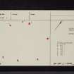
Plan of stone circle. Incomplete. |
|
Item Level |
|
|
Photographs and Off-line Digital Images |
DC 4787 |
Papers of Professor Alexander Thom, engineer and archaeologist, Dunlop, East Ayrshire, Scotland |
Plan of stone circle. Annotated. |
|
Item Level |
|
|
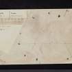
Photographs and Off-line Digital Images |
DC 4789 |
Papers of Professor Alexander Thom, engineer and archaeologist, Dunlop, East Ayrshire, Scotland |
Plan of stone circle. |
|
Item Level |
|
|
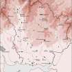
Prints and Drawings |
DC 32190 |
Records of the Royal Commission on the Ancient and Historical Monuments of Scotland (RCAHMS), Edinbu |
Map showing the distribution of stone axes and Neolithic monuments (long cairns, bank barrow, standing stones, cursus, stone circles, henges and pitted enclosures) in Annandale and Eskdale. Published in Eastern Dumfriesshire: an archaeological landscape. |
1996 |
Item Level |
|
|
Manuscripts |
MS 430 |
Papers of Professor Alexander Thom, engineer and archaeologist, Dunlop, East Ayrshire, Scotland |
Collection of notebooks (99 in total). |
|
Item Level |
|
|
Digital Files (Non-image) |
GV 007446 |
Records of the Royal Commission on the Ancient and Historical Monuments of Scotland (RCAHMS), Edinbu |
Map showing the distribution of stone axes and Neolithic monuments (long cairns, bank barrow, standing stones, cursus, stone circles, henges and pitted enclosures) in Annandale and Eskdale. Published in Eastern Dumfriesshire: an archaeological landscape. |
1996 |
Item Level |
|
 |
On-line Digital Images |
SC 1917584 |
Records of the Royal Commission on the Ancient and Historical Monuments of Scotland (RCAHMS), Edinbu |
Map showing the distribution of stone axes and Neolithic monuments (long cairns, bank barrow, standing stones, cursus, stone circles, henges and pitted enclosures) in Annandale and Eskdale. Published in Eastern Dumfriesshire: an archaeological landscape. |
1996 |
Item Level |
|
 |
On-line Digital Images |
SC 2471630 |
Records of the Ordnance Survey, Southampton, Hampshire, England |
Whitcastles, NY28NW 4, Ordnance Survey index card, page number 1, Recto |
1958 |
Item Level |
|
 |
On-line Digital Images |
SC 2471631 |
Records of the Ordnance Survey, Southampton, Hampshire, England |
Whitcastles, NY28NW 4, Ordnance Survey index card, page number 2, Recto |
1958 |
Item Level |
|
 |
On-line Digital Images |
SC 2471632 |
Records of the Ordnance Survey, Southampton, Hampshire, England |
Whitcastles, NY28NW 4, Ordnance Survey index card, page number 2, Recto |
1958 |
Item Level |
|
 |
On-line Digital Images |
SC 2471633 |
Records of the Ordnance Survey, Southampton, Hampshire, England |
Whitcastles, NY28NW 4, Ordnance Survey index card, page number 1, Recto |
1958 |
Item Level |
|
|
All Other |
551 166/1/1 |
Records of the Ordnance Survey, Southampton, Hampshire, England |
Archaeological site card index ('495' cards) |
1947 |
Sub-Group Level |
|


