 |
On-line Digital Images |
SC 384431 |
|
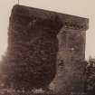
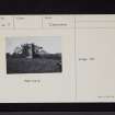
Copy of historic photograph showing view from N. |
|
Item Level |
|
 |
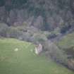
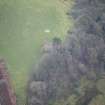
On-line Digital Images |
DP 107887 |
RCAHMS Aerial Photography Digital |
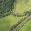
Oblique aerial view of Woodhouse Tower, taken from the E. |
3/8/2011 |
Item Level |
|
 |
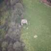
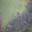
On-line Digital Images |
DP 107888 |
RCAHMS Aerial Photography Digital |
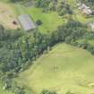
Oblique aerial view of Robgill Tower and Woodhouse Tower, taken from the ENE. |
3/8/2011 |
Item Level |
|
 |
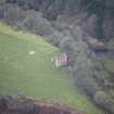
On-line Digital Images |
DP 271070 |
Historic Environment Scotland |
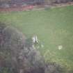
Oblique aerial view. |
22/2/2018 |
Item Level |
|
 |
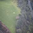
On-line Digital Images |
DP 271071 |
Historic Environment Scotland |
Oblique aerial view. |
22/2/2018 |
Item Level |
|
 |
On-line Digital Images |
DP 271072 |
Historic Environment Scotland |
Oblique aerial view. |
22/2/2018 |
Item Level |
|
 |
On-line Digital Images |
DP 271073 |
Historic Environment Scotland |
Oblique aerial view. |
22/2/2018 |
Item Level |
|
 |
On-line Digital Images |
DP 271074 |
Historic Environment Scotland |
Oblique aerial view. |
22/2/2018 |
Item Level |
|
 |
On-line Digital Images |
DP 271075 |
Historic Environment Scotland |
Oblique aerial view. |
22/2/2018 |
Item Level |
|
 |
On-line Digital Images |
DP 271076 |
Historic Environment Scotland |
Oblique aerial view. |
22/2/2018 |
Item Level |
|
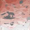 |
On-line Digital Images |
SC 2233915 |
Records of the Royal Commission on the Ancient and Historical Monuments of Scotland (RCAHMS), Edinbu |
Solway Plain landscape case-study area: map showing the main medieval monuments, the extent of cultivation in about 1750, and areas of bogs and wetlands. Published in Eastern Dumfriesshire: an archaeological landscape.
|
1996 |
Item Level |
|
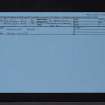 |
On-line Digital Images |
SC 2471508 |
Records of the Ordnance Survey, Southampton, Hampshire, England |
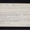
Woodhouse Tower, NY27SE 5, Ordnance Survey index card, Recto |
1958 |
Item Level |
|
 |
On-line Digital Images |
SC 2471509 |
Records of the Ordnance Survey, Southampton, Hampshire, England |
Woodhouse Tower, NY27SE 5, Ordnance Survey index card, Recto |
1958 |
Item Level |
|
 |
On-line Digital Images |
SC 2471510 |
Records of the Ordnance Survey, Southampton, Hampshire, England |
Woodhouse Tower, NY27SE 5, Ordnance Survey index card, Recto |
1958 |
Item Level |
|


