
Carn Nam Buth


Broch (Iron Age)(Possible)
Site Name Carn Nam Buth
Classification Broch (Iron Age)(Possible)
Alternative Name(s) Upper Suisgill
Canmore ID 6700
Site Number NC82SE 11
NGR NC 8989 2498
Datum OSGB36 - NGR
Permalink http://canmore.org.uk/site/6700


- Council Highland
- Parish Kildonan
- Former Region Highland
- Former District Sutherland
- Former County Sutherland
NC82SE 11 8989 2498.
(NC 8989 2498) Dun (NR)
OS 6"map, (1963)
A dun was discovered during field investigation.
Visited by OS (W D J) 30 May 1961; Visible on RAF air photograph 106G/Scot/UK 164: 4234-5
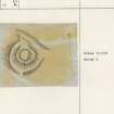
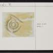
Situated on the flattened summit of a low knoll separated from the hill behind by a natural gully, and some 15 - 20m above the river plain, are the fragmentary remains of a circular stone-walled fortification. It measures approximately 17.0m in overall diameter, but it has been so comprehensively robbed that most of the wall is reduced to a heather-covered stony scarp. Only on the E side is there a counterscarp bank remaining, 5.0m wide and 0.8m high; the content seems to be of stones suitable for building, with an admixture of earth. Two, possibly three stones around the perimeter are probably footings of the outer face.
The knoll has been scarped all round to provide an outer defence which is the most obvious part of the work. It takes the form of an outer bank on the S side, a narrow terrace on the N and W sides, and in the E is the afore-mentioned natural gully. The entrance is not visible, but there is an obvious line of approach from the N.
Despite its poor state of preservation, it is possible that this feature is a broch as evidenced by its size, shape and position on a reasonably defensive site over-looking cultivable land. It was probably robbed to build the minor deserted settlement to the NE (see M), and the 'post-Clearances' field wall to the E.
Revised at 1/10,000
Visited by OS (N K B) 22 February 1977
Field Visit (6 June 1991)
What may be the wasted remains of a broch occupy a knoll situated on the edge of a terrace to the W of the River Helmsdale. It measures about 15m in length by 13m within a heavily robbed wall at least 3.6m in thickness with a possible entrance on the NNE, where there is a dip in the wall. A few outer facing-stones are visible on the SSW of the knoll. The sides of the knoll have been artificially steepened and further protection has been provided by an enclosing ditch (up to 6m broad and 1m deep on the S), which is accompanied by an external bank on the N, W and S. A trackway, which leads tangentially past the E of the knoll, has removed all trace of the external bank.
(KILD91 192)
Visited by RCAHMS (PJD) 6 June 1991
Publication Account (2007)
NC82 5 UPPER SUISGILL (‘Carn nam Buth’)
NC/8989 2498
This possible broch or ditched home-stead or dun in Kildonan stands on the summit of a prominent knoll but any structure on it is almost completely destroyed [2]. There are however traces of defences surrounding the knoll [2], although the possibility of the site being a more recent homestead, or a dun, has been raised [1].
Sources: 1. NMRS site no. NC 82 SE 11: 2. Swanson (ms) 1985, 798 - 99 and plan: 4. RCAHMS, Strath of Kildonan: an archaeological survey. Edinburgh 1993.
E W MacKie 2007

