
Unst, Loch Of Bordastubble


Standing Stone (Prehistoric)
Site Name Unst, Loch Of Bordastubble
Classification Standing Stone (Prehistoric)
Alternative Name(s) Loch Of Stourhall; Lund
Canmore ID 67
Site Number HP50SE 9
NGR HP 5787 0334
Datum OSGB36 - NGR
Permalink http://canmore.org.uk/site/67


- Council Shetland Islands
- Parish Unst
- Former Region Shetland Islands Area
- Former District Shetland
- Former County Shetland
HP50SE 9 5787 0334
(HP 5786 0336) Standing Stone (NR)
OS 6" map, Shetland, 2nd ed., (1900).
See also HP50SE 26.
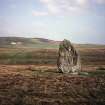
A massive and irregularly-shaped standing stone, some 12' high, with its major axis NW-SE. It has a girth of 19' 6" at base and of 22' at 4' above ground, where it reaches its maximum width of 8' 2".
In spite of having been packed at the base, it shows a decided tilt towards the SW. The few large stones lying round about seem to have no connection with it.
RCAHMS 1946, visited 1930.
As described and illustrated.
Visited by OS (NKB), 5 May 1969.
Using this 4m high standing stone as backsight, the standing stone at Burragarth [HP50SE 26] at a distance of 0.7km to the NNW, acts as skyline foresight for a hitherto unnoticed lunar alignment with declination 28'.629
H Exton 1994b.
Publication Account (1997)
This is a truly massive boulder of gneiss, 3.6m high and a girth of 6.7m (colour photograph on pA3). Its location on low-lying ground is not typical, and it may be that this natural glacial boulder proved too huge to move. An attempt seems to have been made to chock it into an optimum position.
Information from ‘Exploring Scotland’s Heritage: Shetland’, (1997).

