 |
On-line Digital Images |
SC 393323 |
|
CROPPED IMAGE |
|
Item Level |
|
 |
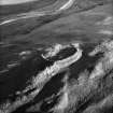
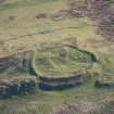
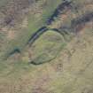
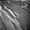
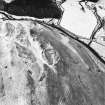
On-line Digital Images |
SC 1031200 |
RCAHMS Aerial Photography |
Carthur Hill, oblique aerial view, taken from the SW, centred on a fort and cultivation remains. |
22/2/1996 |
Item Level |
|
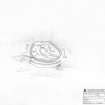 |
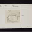
On-line Digital Images |
SC 1346212 |
Records of the Royal Commission on the Ancient and Historical Monuments of Scotland (RCAHMS), Edinbu |
Survey drawing; Plan of Carthur Hill fort. |
4/9/1990 |
Item Level |
|
 |
On-line Digital Images |
DP 266386 |
Historic Environment Scotland |
Oblique Aerial view. |
16/11/2017 |
Item Level |
|
 |
On-line Digital Images |
DP 266387 |
Historic Environment Scotland |
Oblique Aerial view. |
16/11/2017 |
Item Level |
|
 |
On-line Digital Images |
DP 266388 |
Historic Environment Scotland |
Oblique Aerial view. |
16/11/2017 |
Item Level |
|
 |
On-line Digital Images |
DP 266389 |
Historic Environment Scotland |
Oblique Aerial view. |
16/11/2017 |
Item Level |
|
 |
On-line Digital Images |
DP 266390 |
Historic Environment Scotland |
Oblique Aerial view. |
16/11/2017 |
Item Level |
|
 |
On-line Digital Images |
DP 266391 |
Historic Environment Scotland |
Oblique Aerial view. |
16/11/2017 |
Item Level |
|
 |
On-line Digital Images |
DP 266392 |
Historic Environment Scotland |
Oblique Aerial view. |
16/11/2017 |
Item Level |
|
 |
On-line Digital Images |
DP 266393 |
Historic Environment Scotland |
Oblique Aerial view. |
16/11/2017 |
Item Level |
|
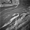 |
On-line Digital Images |
SC 1760661 |
RCAHMS Aerial Photography |
Oblique aerial view. |
1989 |
Item Level |
|
 |
On-line Digital Images |
SC 1760662 |
RCAHMS Aerial Photography |
Oblique aerial view. |
1989 |
Item Level |
|
 |
On-line Digital Images |
SC 1760663 |
RCAHMS Aerial Photography |
Oblique aerial view. |
1989 |
Item Level |
|
 |
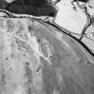
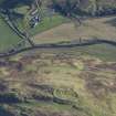
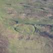
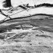
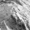
On-line Digital Images |
SC 1760724 |
RCAHMS Aerial Photography |
Rangecastle Hill, oblique aerial view, taken from the E, centred on the remains of a fort and round house, with another fort to the top of the photograph. |
22/2/1996 |
Item Level |
|
 |
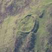
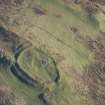
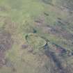
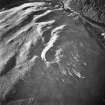
On-line Digital Images |
SC 1760725 |
RCAHMS Aerial Photography |
Carthur Hill, oblique aerial view, taken from the NW, centred on a fort and cultivation remains. |
22/2/1996 |
Item Level |
|
 |
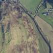
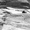
On-line Digital Images |
SC 1760726 |
RCAHMS Aerial Photography |
Carthur Hill, oblique aerial view, taken from the SW, centred on a fort and cultivation remains. |
22/2/1996 |
Item Level |
|
 |
On-line Digital Images |
SC 1760727 |
RCAHMS Aerial Photography |
Carthur Hill, oblique aerial view, taken from the NE, centred on a fort and cultivation remains. |
22/2/1996 |
Item Level |
|
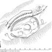 |
On-line Digital Images |
SC 1917665 |
Records of the Royal Commission on the Ancient and Historical Monuments of Scotland (RCAHMS), Edinbu |
Publication drawing; Plan of Carthur Hill fort. |
3/8/1994 |
Item Level |
|
 |
On-line Digital Images |
SC 2471175 |
Records of the Ordnance Survey, Southampton, Hampshire, England |
Carthur Hill, NY19SE 10, Ordnance Survey index card, page number 1, Recto |
1958 |
Item Level |
|
 |
On-line Digital Images |
SC 2471176 |
Records of the Ordnance Survey, Southampton, Hampshire, England |
Carthur Hill, NY19SE 10, Ordnance Survey index card, page number 2, Verso |
1958 |
Item Level |
|
 |
On-line Digital Images |
SC 2471177 |
Records of the Ordnance Survey, Southampton, Hampshire, England |
Carthur Hill, NY19SE 10, Ordnance Survey index card, Recto |
1958 |
Item Level |
|
 |
On-line Digital Images |
SC 2471178 |
Records of the Ordnance Survey, Southampton, Hampshire, England |
Carthur Hill, NY19SE 10, Ordnance Survey index card, Recto |
1958 |
Item Level |
|
 |
On-line Digital Images |
SC 2471179 |
Records of the Ordnance Survey, Southampton, Hampshire, England |
Carthur Hill, NY19SE 10, Ordnance Survey index card, Recto |
1958 |
Item Level |
|


