
Greenhillhead


Fort (Iron Age)
Site Name Greenhillhead
Classification Fort (Iron Age)
Alternative Name(s) Greenhillhead, Lochmaben
Canmore ID 66842
Site Number NY18SW 35
NGR NY 10218 80463
Datum OSGB36 - NGR
Permalink http://canmore.org.uk/site/66842


- Council Dumfries And Galloway
- Parish Lochmaben
- Former Region Dumfries And Galloway
- Former District Annandale And Eskdale
- Former County Dumfries-shire
Aerial Photographic Interpretation (20 February 1996)
NY 102 804 NY18SW 35
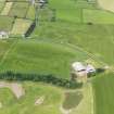
Air photography (CUCAP 1974; J Dewar 1975; RCAHMSAP 1983, 1984 and 1989) has recorded the cropmarks of a multivallate fort on the crest of a low ridge immediately S of Greenhillhead steading (NY18SW 117). The most prominent of the ditches on the aerial photographs is the innermost, which is about 6m broad and encloses an oval area measuring about 75m from N to S by 40m transversely. There is a well-defined entrance on the W, but there is no trace of a corresponding gap in the two outer ditches, which therefore represent a separate period of occupation. There are also traces of another, narrower, ditch immediately within, and partly masked by, the broad main inner ditch; this can also be seen cutting across the entrance on the W unbroken on some of the aerial photographs (NMRS DF 3056) It is uncertain whether this circuit is associated with the outer ditches, or whether it indicates a third period of occupation.
Information from RCAHMS (SPH), 20 February 1996.
Listed as fort.
RCAHMS 1997.
Aerial Photographic Transcription (16 October 2012)
An interpretative transcription, or mapping, of information on oblique aerial photographs was produced on 16 October 2012.
Note (12 June 2014 - 18 October 2016)
Cropmarks have revealed a multivallate fort situated on the N end of a low hillock in the bottom of Annandale immediately S of Greenhillhead steading. Oval on plan, it measures about 75m from N to S by 40m transversely within three concentric ditches, the innermost of which is the broadest and is up to 6m in breadth; allowing for a rampart some 5m in thickness, the interior extends to about 0.15ha. There is at least one entrance through the innermost ditch on the W, but the outer ditches pass it by unbroken, implying that the ditch system represents at least two periods of construction. In addition there are traces of a small ditch immediately within the innermost ditch, and this too is carried across the entrance on the W. A possible second entrance through the innermost ditch can be detected on the ESE, and though the natural markings here obscure the line of the outer defences, the clarity of the rest of their circuit suggests that this is where the entrance through the outer ditches lies. There are no clearly defined features within the interior.
Information from An Atlas of Hillforts of Great Britain and Ireland – 18 October 2016. Atlas of Hillforts SC0965

