
Lunelly Tower


Tower House (Medieval)
Site Name Lunelly Tower
Classification Tower House (Medieval)
Canmore ID 66809
Site Number NY18SE 7
NGR NY 1971 8236
Datum OSGB36 - NGR
Permalink http://canmore.org.uk/site/66809


- Council Dumfries And Galloway
- Parish Hutton And Corrie
- Former Region Dumfries And Galloway
- Former District Annandale And Eskdale
- Former County Dumfries-shire
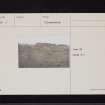
Poorly preserved remains of probable 16th century tower house located at bend in river of Water of Milk on south-facing slopes within improved pasture farmland. Main views are along river valley to east and west.
information from Héléna Gray, (CFA Archaeology Ltd), August 2015
OASIS ID: cfaarcha1-278420
NY18SE 7 1971 8236
(NY 1971 8236) Lunelly Tower (NR) (Remains of)
OS 6" map (1957)
A fragment of the S wall, 20 ft long, 25 ft high and 3 ft 8 ins thick remained in 1912. Of old it was called Lun, and was the seat of the Corrie family, probably some sort of wooden stockaded dwelling, till 1484. In 1516 the lands of Lund passed to the Johnstone family who lived here for three generations and probably built the tower.
RCAHMS 1920; R C Reid 1934
All that remains of Lunelly Tower is a rectangular mound of grass-covered masonary, about 2.0m high, probably the barrel-vaulted basement. A fragment of the outer wall face, about 4.0m long and about 1.4m high, is exposed on the south side. To the west, north and east of the tower the foundations of a courtyard wall, now generally a slight, stony bank, 0.4m high, at the SE corner of which are the possible foundations of a small turret.
Revised at 25".
Visited by OS (WDJ) 20 May 1966.
Note (1997)
NY 1971 8236 NY18SE 7
Listed as tower.
RCAHMS 1997.
Project (29 May 2014)
An archaeological evaluation was undertaken by CFA Archaeology Ltd, a desk based assessment and walk over survey (May 29th 2014) was conducted
The historic environment record within the Site Boundary is relatively limited, although there is some potential for the proposed development site to contain previously unknown heritage assets from at least the later prehistoric period onwards, given the historic landscape character of the wider area. Taking this into account, the archaeological potential of the proposed development site is considered to be low.
A summary assessment, on a site by site basis, of the predicted effects on the settings of assets within a 10km radius where the blade tip ZTV indicates that there would be theoretical views of one or more turbines
information from Héléna Gray, (CFA Archaeology Ltd), August 2015
OASIS ID: cfaarcha1-278420

