|
Photographs and Off-line Digital Images |
G 94653 PO |
Alastair Maxwell-Irving |
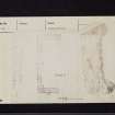
Photocopy of drawing showing survey plan. |
1991 |
Item Level |
|
 |
On-line Digital Images |
SC 2470590 |
Records of the Ordnance Survey, Southampton, Hampshire, England |
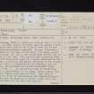
Kirkconnel Tower, NY17NE 3, Ordnance Survey index card, page number 1, Recto |
1958 |
Item Level |
|
 |
On-line Digital Images |
SC 2470591 |
Records of the Ordnance Survey, Southampton, Hampshire, England |
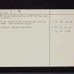
Kirkconnel Tower, NY17NE 3, Ordnance Survey index card, page number 2, Verso |
1958 |
Item Level |
|
 |
On-line Digital Images |
SC 2470592 |
Records of the Ordnance Survey, Southampton, Hampshire, England |
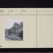
Kirkconnel Tower, NY17NE 3, Ordnance Survey index card, page number 1, Recto |
1958 |
Item Level |
|
 |
On-line Digital Images |
SC 2470593 |
Records of the Ordnance Survey, Southampton, Hampshire, England |
Kirkconnel Tower, NY17NE 3, Ordnance Survey index card, page number 2, Verso |
1958 |
Item Level |
|
|
All Other |
551 166/1/1 |
Records of the Ordnance Survey, Southampton, Hampshire, England |
Archaeological site card index ('495' cards) |
1947 |
Sub-Group Level |
|


