
Suisgill


Cup Marked Stone (Neolithic) - (Bronze Age), Hut Circle (Prehistoric)(Possible), Souterrain (Prehistoric)
Site Name Suisgill
Classification Cup Marked Stone (Neolithic) - (Bronze Age), Hut Circle (Prehistoric)(Possible), Souterrain (Prehistoric)
Canmore ID 6642
Site Number NC82NE 15
NGR NC 89787 25062
Datum OSGB36 - NGR
Permalink http://canmore.org.uk/site/6642


- Council Highland
- Parish Kildonan
- Former Region Highland
- Former District Sutherland
- Former County Sutherland
Field Visit (5 June 1961)
NC82NE 15 8979 2506
See also NC82NE 38.
(NC 8979 2506) Earth House (NR)
OS 6" map, 1962.
The remains of a souterrain, discovered during field investigation, beside the road, whose construction has cut away all but the end 4m. Entry is prevented by an iron grille over the opening, but the souterrain has been of the usual drystone construction, 1.2m wide and 2m high. The roof slabs are still in situ.
Visited by OS (J L D) 5 June 1961
Field Visit (2 December 1976)
No change to previous field report; there is no evidence of an associated hut circle.
Visited by OS (J B) 2 December 1976
Field Visit (10 April 1991)
The remains of this souterrain lie to the NE of the public road (A897). Aligned from NNE to SSW, its SSW end has been destroyed during the construction of the road, the surviving portion measuring 4.1m in length, 1.3m in breadth and 1m in height. An aumbry is visible at the end of the SE wall of the passage. Immediately to the ESE of the souterrain there is a roughly circular platform which may have been the stance for a hut-circle. There is a slab resting on the surface above the souterrain with at least five slight cup-marks on its face.
(KILD91 191)
Visited by RCAHMS (DCC) 10 April 1991.
Note (24 October 2019)
Date Fieldwork Started: 24/10/2019
Compiled by: NOSAS
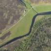
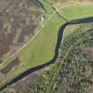
Location Notes: The panel lies in rough grazing on the grassy bank immediately above the entrance to the damaged souterrain at Suisgill. The souterrain is close to the main road, and a rough track which leads off it has damaged the entrance. It is at the E edge of a flat area of ground where the valley of the Suisgill Burn opens out as it joins the Helmsdale River.
Panel Notes: The panel is a triangular slab of schist 0.8m x 0.6m and rising to 0.2m above the ground. The surface is flat and horizontal, on two levels separated by a step in the rock. The higher N part has 2 cups, and the S part has 6.

