 |
On-line Digital Images |
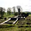
SC 381733 |
|
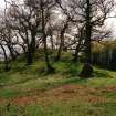
View from N. |
|
Item Level |
|
 |
On-line Digital Images |
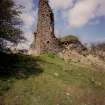
SC 381735 |
|
View from SE. |
|
Item Level |
|
 |
On-line Digital Images |
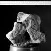
SC 381737 |
|
Detail of ridge finial. |
|
Item Level |
|
 |
On-line Digital Images |
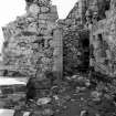
SC 381739 |
|
View of tower entrance. |
|
Item Level |
|
 |
On-line Digital Images |
SC 381741 |
|
View of motte from W. |
|
Item Level |
|
 |
On-line Digital Images |
SC 382017 |
Records of the Royal Commission on the Ancient and Historical Monuments of Scotland (RCAHMS), Edinbu |
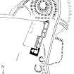
Publication drawing; Plan of Lochwood tower-house and motte. |
21/2/1995 |
Item Level |
|
 |
On-line Digital Images |
SC 382040 |
Records of the Royal Commission on the Ancient and Historical Monuments of Scotland (RCAHMS), Edinbu |
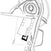
Publication drawing; Plan of Lochwood Castle (The Mount) motte, tower-house and adjacent remains. |
1996 |
Item Level |
|
 |
On-line Digital Images |
SC 1351795 |
Records of the Royal Commission on the Ancient and Historical Monuments of Scotland (RCAHMS), Edinbu |
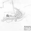
Survey drawing; Plan of Lochwood Castle and Motte. |
4/1991 |
Item Level |
|
 |
On-line Digital Images |
SC 1398296 |
Records of the Royal Commission on the Ancient and Historical Monuments of Scotland (RCAHMS), Edinbu |
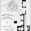
Photographic copy of drawing showing site, block, ground floor and prison plans with sections. |
|
Item Level |
|
 |
On-line Digital Images |
DP 187913 |
RCAHMS Aerial Photography Digital |
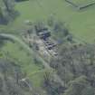
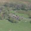
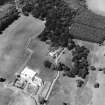
Oblique aerial view of Lochwood Tower, looking SSW. |
29/4/2014 |
Item Level |
|
 |
On-line Digital Images |
DP 187914 |
RCAHMS Aerial Photography Digital |
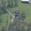
Oblique aerial view of Lochwood Tower, looking S. |
29/4/2014 |
Item Level |
|
 |
On-line Digital Images |
DP 187915 |
RCAHMS Aerial Photography Digital |
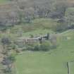
Oblique aerial view of Lochwood Tower, looking ESE. |
29/4/2014 |
Item Level |
|
 |
On-line Digital Images |
DP 187916 |
RCAHMS Aerial Photography Digital |
Oblique aerial view of Lochwood Tower, looking ENE. |
29/4/2014 |
Item Level |
|
 |
On-line Digital Images |
SC 1434736 |
William Notman |
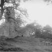
General view of Lochwood Tower from SE. |
c. 1890 |
Item Level |
|
 |
On-line Digital Images |
SC 1434737 |
William Notman |
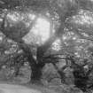
View of trees. |
c. 1890 |
Item Level |
|
 |
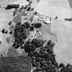
On-line Digital Images |
SC 1759595 |
RCAHMS Aerial Photography |
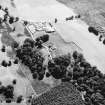
Oblique aerial view. |
1991 |
Item Level |
|
 |
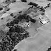
On-line Digital Images |
SC 1759596 |
RCAHMS Aerial Photography |
Oblique aerial view. |
1991 |
Item Level |
|
 |
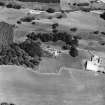
On-line Digital Images |
SC 1759597 |
RCAHMS Aerial Photography |
Oblique aerial view. |
1991 |
Item Level |
|
 |
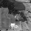
On-line Digital Images |
SC 1759598 |
RCAHMS Aerial Photography |
Oblique aerial view. |
1991 |
Item Level |
|
 |
On-line Digital Images |
SC 1759599 |
RCAHMS Aerial Photography |
Oblique aerial view. |
1991 |
Item Level |
|
 |
On-line Digital Images |
SC 1759600 |
RCAHMS Aerial Photography |
Oblique aerial view. |
1991 |
Item Level |
|
 |
On-line Digital Images |
SC 1917404 |
Records of the Royal Commission on the Ancient and Historical Monuments of Scotland (RCAHMS), Edinbu |
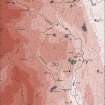
Upper Annandale landscape case-study area: map showing the medieval and later monuments, and the lands of the estates of Crunzierton in 1361 and Dumgree in 1605. Published in Eastern Dumfriesshire: an archaeological landscape. |
1996 |
Item Level |
|
 |
On-line Digital Images |
SC 1917780 |
Records of the Royal Commission on the Ancient and Historical Monuments of Scotland (RCAHMS), Edinbu |
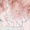
Map showing the distribution of tower-houses and places of strength in Annandale and Eskdale. Published in Eastern Dumfriesshire: an archaeological landscape. |
1996 |
Item Level |
|
 |
On-line Digital Images |
SC 1917782 |
Records of the Royal Commission on the Ancient and Historical Monuments of Scotland (RCAHMS), Edinbu |
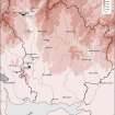
Map showing the distribution of timber and stone castles in Eastern Dumfriesshire and the neighbouring parts of Nithsdale and northern England. Published in Eastern Dumfriesshire: an archaeological landscape. |
1996 |
Item Level |
|


