
Trailflat, Old Parish Church


Burial Ground (Medieval), Church (Medieval), Grave Slab (15th Century), Rubbing Stone (Post Medieval)
Site Name Trailflat, Old Parish Church
Classification Burial Ground (Medieval), Church (Medieval), Grave Slab (15th Century), Rubbing Stone (Post Medieval)
Alternative Name(s) Trailflat Church And Churchyard
Canmore ID 66323
Site Number NY08SW 15
NGR NY 04805 84069
Datum OSGB36 - NGR
Permalink http://canmore.org.uk/site/66323


- Council Dumfries And Galloway
- Parish Tinwald
- Former Region Dumfries And Galloway
- Former District Nithsdale
- Former County Dumfries-shire
NY08SW 15 04805 84069.
(NY 0480 8406) Trailflat Ch (NR) (remains of)
OS 6" map (1971)
For present (Tinwald) parish church (NY 0025 8163), see NY08SW 26.00.
The parishes of Tinwald and Trailflat were united in 1650, at which date Dungrie was united to Kirkpatrick-Juxta, except for a portion which was annexed to Johnstone.
H Scott 1915-61.
Trailflat Church is rectangular on plan, measuring 42 ft 3 ins by 16 ft within walls 2 ft 4 ins thick. The highest part of the walls now standing is the SW angle, where the stonework is still some 8 ft high. It was granted to Kelso Abbey in the 12th century. The parish was united with Tinwald in 1650, and the church was partly ruinous by 1684.
RCAHMS 1920, visited 1912; G Chalmers 1890
Generally as described above.
Visited by OS (RD) 20 June 1966.
(Glasgow, Nithsdale). Granted to Kelso by William de Carnato, c. 1180, this grant was conformed by William the Lion (1165-1214) and to the uses of the abbey by Jocelin, bishop of Glasgpw (1179x89). A vicarage had been erected before 1275, but this was apparently transitory, as both parsonage and vicarage teinds evidently lay with the abbey at the Reformation. Most of the revenues, however, appear to have been devoted to the use of the cell of Lesmahagow, the cure itself being served by a chaplain.
I B Cowan 1967.
A 14th century tomb slab, 6 ft long, is in Trailflat churchyard. It is uninscribed but for a small incised cross 4 ins long at the 'head' end. A small dolerite rubber was ploughed up in the field next to the churchyard in 1967.
A McCracken 1967
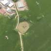
The remains of the medieval parish church of Trailflat stand within its burial-ground in a commanding position looking out across the low-lying undulating terrain which opens out into Annandale. Except for its W gable, the church has been reduced to the lowest courses of its walls, and measures 15.6m from E to W by 6.1m internally; the clay-bonded rubble walls are 0.7m in thickness. The W gable stands to a height of up to 2.2m and incorporates an inserted square-headed lintelled window with splayed ingoes, wrought with a 50mm chamfered arris and dressed for half-glazing. The entrance was in the S wall. A sandstone block (lying loose amid rubble to the interior), checked and wrought with a 65mm chamfered arris, could be a door rybat. The interior is partially obscured by collapse and stone cleared from the burial-ground, including fragments of several 18th-century table-tombs.
Within the burial-ground, on the S side of the church, there are a number of 17th and 18th-century graveslabs and stones. A tapered slab, which is extremely worn, now placed between two table tombs 11m to the S of the entrance to the church, is probably medieval. The slab measures 1.84m in length, 0.30 to 0.43m in width and 0.20m in thickness. A number of 18th-century gravestones have been removed from their original positions and are now placed upright against the walls of the church.
The burial-ground has been subject to zealous tidying by the District Council.
Visited by RCAHMS (IMS/PC) 30 September 1993.
(Remains of the church of a parish which was united with Tinwald in 1650). Ruin of a rubble-built rectangular church, c. 12.8 by 4.9m.
J Gifford 1996.

