
Gars Hill, West Roucan


Fort (Iron Age)
Site Name Gars Hill, West Roucan
Classification Fort (Iron Age)
Alternative Name(s) Garrs
Canmore ID 66134
Site Number NY07NW 1
NGR NY 02583 78644
Datum OSGB36 - NGR
Permalink http://canmore.org.uk/site/66134


- Council Dumfries And Galloway
- Parish Torthorwald
- Former Region Dumfries And Galloway
- Former District Nithsdale
- Former County Dumfries-shire
NY07NW 1 0258 7863.
(NY 0258 7863) Fort (NR) (site of)
OS 6" map (1971)
Fort, Garrs: This fort is described in the Statistical Account (OSA, 1792) as "about 30 yds in diameter, surrounded in some parts with two, and in other places with three large trenches". In 1912, only the faint outline of a low rampart forming an oval enclosure could be seen.
RCAHMS 1920, visited 1912
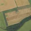
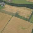
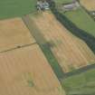
Situated on the summit of a low hill, this fort is almost entirely ploughed out but the courses of two nearly concentric ramparts can be faintly traced, and are best discerned on the NW and SE as crests of indeterminate height on the gentle slopes of the hill. Elsewhere, the ramparts have been entirely obliterated and their courses can only be conjectured. The sectional outline of the fort can be seen quite well against the skyline from distant lower ground to the W.
From the scant remains the overall size of this oval fort seems to have been 108.0m NW-SE by approximately 95.0m transversely.
Revised at 25".
Visited by OS (RDL) 11 December 1963
Photographed by the RCAHMS in 1978.
Aerial Photographic Transcription (9 July 2012)
This fort has been recorded as a cropmark on oblique aerial photographs (RCAHMSAP 1978, 1989). It is depicted on the 1st and 2nd editions of the OS 6-inch map (Dumfries-shire 1854, sheet 72NY07nw, Dumfries-shire 1910 sheet 72NY07nw).
Information from RCAHMS (KHJM) 9 July 2012
Note (21 May 2014 - 2 August 2016)
This fort, which survived relatively intact until 1856 but had been ploughed down by 1899, is now largely known only as a cropmark, though in 1963 faint traces of its defences were still visible on the NW and SE. The cropmarks are not particularly distinct, representing up to three concentric ditches, but it is shown as a bivallate fort on the 1st edition OS 25-inch map, with an oval interior measuring about 60m from NW to SE by 50m transversely (0.23ha) and some elements of the cropmarks on the SE are possibly reflect the presence of internal quarry scoop behind the inner rampart. The position of the entrance is unknown.
Information from An Atlas of Hillforts of Great Britain and Ireland – 02 August 2016. Atlas of Hillforts SC0855

