
Old Caerlaverock Castle


Castle (Medieval), Earthwork(S) (Period Unassigned)
Site Name Old Caerlaverock Castle
Classification Castle (Medieval), Earthwork(S) (Period Unassigned)
Alternative Name(s) Caerlaverock, Old Castle
Canmore ID 66101
Site Number NY06NW 7
NGR NY 02706 65451
Datum OSGB36 - NGR
Permalink http://canmore.org.uk/site/66101


- Council Dumfries And Galloway
- Parish Caerlaverock
- Former Region Dumfries And Galloway
- Former District Nithsdale
- Former County Dumfries-shire
NY06NW 7 02706 65451
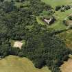
For Caerlaverock Castle (NY 0255 6560), see NY06NW 6.
See also NY06NW 12.
(NY 0275 6550) Old Caerlaverock Castle (NR) (site of)
OS 1:10000 map (1971)
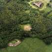
These earthworks were identified by the RCAHMS (1920, visited 1914) as 'Old Caerlaverock Castle', the predecessor of the present castle (NY06NW 6) and necessarily obsolete before 1300.
Without excavation there can be no certainty in this dating. B H St J O'Neil (1952) thinks that it was a later medieval temporary structure used when the main castle was destroyed about 1356-7; Cruden merely states that a 13th century plinth course was found in situ many years ago - possibly during excavations made in 1868.
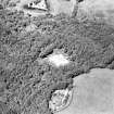
In 1914, the earthworks were traced with difficulty. An enceinte, roughly a parallelogram on plan, measuring 86 ft from NE to SW by 97 ft transversely, was enclosed by a curtain wall with the lower stage of a rectangular tower in the N angle. Within the wall are the remains of a rectangular structure with walls 3 1/2 ft thick. The silted moat, supplied by a burn on the E, was originally about 10 ft deep. The outer rampart is level with the enceinte.
Earthworks of various forms lie adjacent to this castle. Those to the NE were excavated by Truckell in 1948 when rubble wall foundations of considerable extent were exposed; in one of these were found a corroded axe-head and two pieces of grey, green-glazed medieval pottery. These finds were deposited with Durham University and have been lost trace of.
S Cruden 1960; A E Truckell 1950; A E Truckell and J Williams 1967
The earthworks of 'Old Caerlaverock Castle' are as described and generally as planned by the RCAHMS but are now much mutilated and obscured by vegetation. The moat is now dry. No trace of the actual castle could be seen. Dense, impenetrable vegetation completely obscured all but a small part of the various earthworks adjacent to the castle site. No information was found to explain any of these earthworks.
Earthworks resurveyed at 1:2500.
See also NY06NW 12.
Visited by OS (WDJ) 12 August 1965
NY 027 654. Excavation and survey was undertaken in 1998 on the site of the earlier of the two 13th-century castles built by the Maxwells at Caerlaverock. The first or 'Old' Castle is believed to have been established in the 1220s and abandoned 50 years later in favour of the surviving triangular plan castle. The aim of the work is to inform a scheme for the laying-out and interpretation of the site to visitors.
Fieldwork commenced in February with trial trenching and augering within the flat-bottomed basin immediately to the S of the castle mound, presumed to have been a contemporary harbour. No evidence of a revetment for the bank bounding the harbour was found, although only the N side of the harbour was tested. The upper part of the bank separating the harbour from the castle moat was demonstrated to consist of clean redeposited natural silt and clay, mounded over a layer of decayed turf. This may be interpreted as the marking out of the line of the bank in turf prior to the deposition of further material (excavated from the harbour and castle moat), in the same manner as the earthworks of the later castle. The presumed floor of the harbour basin was encountered just 0.5m below the present ground surface. No finds of any sort were recovered.
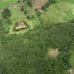
Fieldwalking in the surrounding woods revealed a previously unmapped sub-rectangular enclosure 70m to the SW of the castle mound. The enclosure, c 70m N-S by 50m E-W, is enclosed on the W, N, and E sides by a low bank (c 0.3m high by 2m wide) with an external ditch just perceptible. The S side of the enclosure is formed by a long double-banked earthwork, mapped by the OS and enclosing a much larger area. The dates of both features are unknown.
The main focus of the 1998 fieldwork was excavation on the 27 x 27m top of the castle mound, undertaken from mid-June to mid-September. Despite extensive robbing of the masonry of the wall footings, a sequential structural development was revealed. Building appears to have started in the E corner with a two-storied block, measuring c 10.5 x 7.5m externally. It was built upon a foundation trench filled with layers of large river cobbles, and there was evidence for an external stair. A stone curtain wall was subsequently built around the mound perimeter and further internal buildings of stone added along the SE and SW sides. That along the SW side measures c 15 x 6.5m internally, with no internal divisions apparent, suggesting a ground-floor hall. However, both the curtain wall and the buildings of this second phase of work were built directly onto the natural silt and clay with no proper foundations. Structural movement is apparent in surviving stretches of walling, and it was perhaps in response to this that external towers were added to the N, W, and S corners of the curtain wall.
The excavations produced a large assemblage of good quality, probably locally produced, green-glazed pottery thought to be of 13th-century date.
Post-demolition activity on the castle mound included the construction of a keyhole-shaped oven, and smithing activity.
Sponsor: Historic Scotland
M L Brann 1998
NY 027 654 Following on from the 1998 fieldwork (Brann 1998), a further four weeks excavation was undertaken in June and July 1999. All remaining baulks and unexcavated areas within the curtain wall were excavated. Excavation down to the metalling of the courtyard revealed a raised cobbled pathway running diagonally across the courtyard, leading from the postulated castle entrance to the foot of the external stair of the chamber block. The established dating and the structural sequence of the castle put forward in the 1998 report was not contradicted by the 1999 excavations. However, further excavation in the interior of the hall revealed the corner post-holes and shallow wall trenches (?sill beam slots) of a substantial, rectilinear timber building. This building demonstrably pre-dates the Phase 3 stone-built hall and the metalling of the courtyard, which was left in situ, but its relationship to the Phase 1 chamber block is not known. The presence of another timber building, sited in the N corner of the castle enceinte, was also confirmed. The relative date of construction of this timber building, evidenced by four large padstones, is also unknown, but the rough metalling of the courtyard respected its footprint. Excavation of smithing deposits in the courtyard, presumed to post-date the abandonment of the castle, produced much slag and furnace fragments.
In addition to work on the castle platform, a trial trench across the moat was opened up on the presumed line of the bridge to relocate the timber bridge footing found in 1978. Excavation of 0.4_0.6m of silt exposed the flat-bottomed clay base of the ditch. A single timber sole-plate for the bridge was found embedded in the clay near the foot of the castle platform scarp.
Archaeomagnetic dating of two areas of burnt clay within the structure interpreted as a hall indicated the last firing was in the ranges AD 1250-75 and 1250-1310.
Sponsor: Historic Scotland
M L Brann 1999
Field Visit (October 1914)
Old Caerlaverock Castle.
The ruins of the old stronghold of the Maxwells at Caerlaverock and the remains of another castle, apparently its predecessor, are situated on the marshy flats of the Solway, at the mouth of the River Nith, some 9 miles south-south-east of the town of Dumfries (fig. II). The older site lies within the Castle wood, 200 yards south-south-east of the other and 500 yards north of high-water mark, and is formed in a bed of clay, while the later building stands on an outcrop of rock.
The buildings and walls on the older site are demolished, and such foundations as remain lie below ground. Many of the stones would be re-used in the later fabric, and even within living memory the site served as a convenient quarry for the neighbourhood. According to Grose (1789) "the site and foundations" were in his time "still very conspicuous." The foundations were again exposed a few years before 1868 (Trans. Dumf. And Gall. Antiq. Soc., 1868-9, p. 12), but no proper record of the work then done can be traced. McDowall, however, reports (History of Dumfries,1873, p. 74 and note) that they showed the building to have had "a quadrilateral form," and therefore contests the suggestion that this was the site of the castle besieged in 1300, which was triangular (cf. p. 23). He adds that the walls exposed were of "unsubstantial build," and possibly those of "an outwork, erected to defend the dam of the fortress," and so prevent the draining of the moat. But even in an outwork - which, moreover, covers an area nearly as great as that of the castle- "unsubstantial" walls would be unsuitable, whatever may be the precise meaning here of so indefinite a description. The enceinte is now so overgrown with trees and littered with fallen stone and the debris of the excavation, that little save the general arrangement of the castle can be traced.
On plan (fig. 12) the enceinte is roughly a parallelogram set with the angles to the cardinal points of the compass, and measuring 86 feet from north-east to south-west and 97 feet from north-west to south-east. The scarp was apparently crowned by a curtain wall, slight traces of which are visible on the southwest side.
At the north angle is a mass of masonry, which slight excavation revealed as the lower stage of a rectangular tower, 17 feet 6 inches broad, projecting 11 feet 6 inches from the face of the curtain walls which it flanked. The masonry is of fine ashlar work, averaging 12 inches long on face, and is built in courses 8 inches high, which are carefully bedded in clay. A splayed member (possibly the uppermost of a heavy basement course) was found returning along the face and east side of the tower (fig. 13). The conformation of the debris at the remaining angles of the enceinte indicates towers at these points. Within the eastern angle of the curtain, but clear of these walls, are the remains of a rectangular structure with walls some 3 feet 6 inches thick.
An eye-witness of the excavations reported from recollection that the buildings were found to be supported on oak piles driven into the clay solum, and that broken pottery was unearthed and replaced at a point marked X on Plan.
OUTWORKS.
The moat has silted up some 2 feet; under the silt the clay bottom is found to be some 10 feet below the level of the enceinte. The width at base varies from 26 feet on the north to 50 feet on the south. A burn on the east drains the moat and, when dammed, would fill it. The outer rampart, on the summit of which to the north and east is a modern roadway, follows the contour of the enceinte and rises to its level. The outer scarp terminates in a ditch some 15 feet in width. An enclosure an acre and a quarter in extent lies immediately to the north-east and is defined by a continuation of the outer ditch and the burn. The masonry exposed in the north tower and the whole arrangement of the castle indicate its erection in the early 13th century.
RCAHMS 1920, visited October 1914
Excavation (1998)
NY 027 654. Excavation and survey was undertaken in 1998 on the site of the earlier of the two 13th-century castles built by the Maxwells at Caerlaverock. The first or 'Old' Castle is believed to have been established in the 1220s and abandoned 50 years later in favour of the surviving triangular plan castle. The aim of the work is to inform a scheme for the laying-out and interpretation of the site to visitors.
Fieldwork commenced in February with trial trenching and augering within the flat-bottomed basin immediately to the S of the castle mound, presumed to have been a contemporary harbour. No evidence of a revetment for the bank bounding the harbour was found, although only the N side of the harbour was tested. The upper part of the bank separating the harbour from the castle moat was demonstrated to consist of clean redeposited natural silt and clay, mounded over a layer of decayed turf. This may be interpreted as the marking out of the line of the bank in turf prior to the deposition of further material (excavated from the harbour and castle moat), in the same manner as the earthworks of the later castle. The presumed floor of the harbour basin was encountered just 0.5m below the present ground surface. No finds of any sort were recovered.
Fieldwalking in the surrounding woods revealed a previously unmapped sub-rectangular enclosure 70m to the SW of the castle mound. The enclosure, c 70m N-S by 50m E-W, is enclosed on the W, N, and E sides by a low bank (c 0.3m high by 2m wide) with an external ditch just perceptible. The S side of the enclosure is formed by a long double-banked earthwork, mapped by the OS and enclosing a much larger area. The dates of both features are unknown.
The main focus of the 1998 fieldwork was excavation on the 27 x 27m top of the castle mound, undertaken from mid-June to mid-September. Despite extensive robbing of the masonry of the wall footings, a sequential structural development was revealed. Building appears to have started in the E corner with a two-storied block, measuring c 10.5 x 7.5m externally. It was built upon a foundation trench filled with layers of large river cobbles, and there was evidence for an external stair. A stone curtain wall was subsequently built around the mound perimeter and further internal buildings of stone added along the SE and SW sides. That along the SW side measures c 15 x 6.5m internally, with no internal divisions apparent, suggesting a ground-floor hall. However, both the curtain wall and the buildings of this second phase of work were built directly onto the natural silt and clay with no proper foundations. Structural movement is apparent in surviving stretches of walling, and it was perhaps in response to this that external towers were added to the N, W, and S corners of the curtain wall.
The excavations produced a large assemblage of good quality, probably locally produced, green-glazed pottery thought to be of 13th-century date.
Post-demolition activity on the castle mound included the construction of a keyhole-shaped oven, and smithing activity.
Sponsor: Historic Scotland
M L Brann 1998
Excavation (1999)
NY 027 654 Following on from the 1998 fieldwork (Brann 1998), a further four weeks excavation was undertaken in June and July 1999. All remaining baulks and unexcavated areas within the curtain wall were excavated. Excavation down to the metalling of the courtyard revealed a raised cobbled pathway running diagonally across the courtyard, leading from the postulated castle entrance to the foot of the external stair of the chamber block. The established dating and the structural sequence of the castle put forward in the 1998 report was not contradicted by the 1999 excavations. However, further excavation in the interior of the hall revealed the corner post-holes and shallow wall trenches (?sill beam slots) of a substantial, rectilinear timber building. This building demonstrably pre-dates the Phase 3 stone-built hall and the metalling of the courtyard, which was left in situ, but its relationship to the Phase 1 chamber block is not known. The presence of another timber building, sited in the N corner of the castle enceinte, was also confirmed. The relative date of construction of this timber building, evidenced by four large padstones, is also unknown, but the rough metalling of the courtyard respected its footprint. Excavation of smithing deposits in the courtyard, presumed to post-date the abandonment of the castle, produced much slag and furnace fragments.
In addition to work on the castle platform, a trial trench across the moat was opened up on the presumed line of the bridge to relocate the timber bridge footing found in 1978. Excavation of 0.4_0.6m of silt exposed the flat-bottomed clay base of the ditch. A single timber sole-plate for the bridge was found embedded in the clay near the foot of the castle platform scarp.
Archaeomagnetic dating of two areas of burnt clay within the structure interpreted as a hall indicated the last firing was in the ranges AD 1250-75 and 1250-1310.
Sponsor: Historic Scotland
M L Brann 1999
Excavation (8 October 2001 - 10 December 2001)
NY 025 656 Monitoring works at Caerlaverock Castle comprised the excavation of soakaway trenches in the grazed pasture field to the W of the Guardianship area, WSW of the visitor centre, and a hole for a septic tank to the SW of the toilet block. The monitoring of the soakaway trenches was under taken on several visits during October, November and December 2001, and the excavation of the pit for the septic tank was monitored in January 2002.
This part of the Guardianship area has been used for dumping debris as well as for the creation of the car park. However, this material appears mostly to have sealed the surviving archaeology rather than destroying it, although it did stop the geophysical surveys from picking up the remains. The ditch cut also shows that archaeology survives below the pasture, despite it having been ploughed in the past. These are encouraging results for the survival of medieval remains in a superficially unpromising part of the monument.
A watching brief was also undertaken in the woods to the S of Caerlaverock Castle while trees were felled. There was no significant damage to the earthworks. The features recorded show that the earthworks in the wooded area of the Caerlaverock Estate are more complex and extensive than usually depicted. It may be possible, with further work, to identify which features are associated with the old castle, with the sieges, with water catchment and with later estate management, potentially including the use of the grounds as romantic pleasure gardens.
G Ewart and P Sharman 2002
Sponsor: Historic Scotland
Kirkdale Archaeology

