
Barjarg House


Country House (16th Century), Tower House (Medieval)
Site Name Barjarg House
Classification Country House (16th Century), Tower House (Medieval)
Alternative Name(s) Barjarg Tower
Canmore ID 65297
Site Number NX89SE 8
NGR NX 87792 90049
Datum OSGB36 - NGR
Permalink http://canmore.org.uk/site/65297


- Council Dumfries And Galloway
- Parish Keir
- Former Region Dumfries And Galloway
- Former District Nithsdale
- Former County Dumfries-shire
NX89SE 8.00 87792 90049
NX89SE 8.01 NX 8769 9004 Stables
NX89SE 8.02 NX 87784 90033 Sundial
NX89SE 8.03 NX 88002 90021 Drybridge
NX88NE 60 NX 88304 89895 Back Lodge
NX88NE 33 Centred on NX 87695 89889 Walled Garden
NX88NE 34 NX 87833 89902 Front Lodge
(NX 87819005) Tower (NR)
OS 6" map (1957)
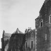
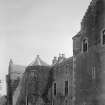
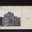
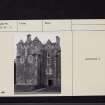
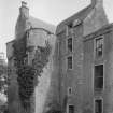
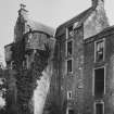
Barjarg Tower: This L-planned tower, dating from the late 16th century, and said to have been given by the Earl of Morton to Thomas Grierson in 1587, forms the E-wing of a mansion built in 1806. Built of red rubble and rising to four storeys and an attic, it has both corbelled angle-turrets and a parapet; the latter may be a modernisation as there has been considerable alteration to the building. The W wing of the modern house is a very fair imitation of the style of the earlier fortalice; it bears a panel dated 1680, which presumably has come from the latter.
RCAHMS 1920, visited 1912; N Tranter 1965; TSA 1962
Barjarg Tower is as described by the previous authorities.
Revised at 1:2500.
Visited by OS (JP) 10 August 1976

