
Rosebank


Ring Ditch (Period Unassigned)
Site Name Rosebank
Classification Ring Ditch (Period Unassigned)
Canmore ID 65271
Site Number NX89SE 37
NGR NX 87825 93713
Datum OSGB36 - NGR
Permalink http://canmore.org.uk/site/65271


- Council Dumfries And Galloway
- Parish Closeburn
- Former Region Dumfries And Galloway
- Former District Nithsdale
- Former County Dumfries-shire
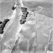
Aerial Photographic Transcription (26 April 2012)
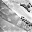
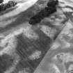
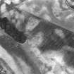
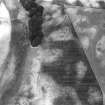
This round barrow has been recorded as a cropmark on oblique aerial photographs (RCAHMSAP 1977, 1995). It is circular in plan and defined by a ditch about 1.9m wide. The enclosed area is 4.5m in diameter and appears to have a central pit. What may be Roman road quarry pits are located 73m t the E of the barrow, running N-S.
Information from RCAHMS (KHJM) 26 April 2012

