 |
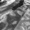
On-line Digital Images |
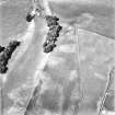
SC 1757886 |
RCAHMS Aerial Photography |
Rosebank, oblique aerial view, taken from the SSW, centred on the cropmark of a ring-ditch. |
10/7/1995 |
Item Level |
|
 |
On-line Digital Images |
SC 1757887 |
RCAHMS Aerial Photography |
Rosebank, oblique aerial view, taken from the SSE, centred on the cropmark of a ring-ditch. |
10/7/1995 |
Item Level |
|
 |
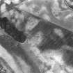
On-line Digital Images |
SC 1757888 |
RCAHMS Aerial Photography |
Rosebank, oblique aerial view, taken from the NNE, centred on the cropmark of a ring-ditch. |
10/7/1995 |
Item Level |
|
 |
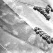
On-line Digital Images |
SC 1757914 |
RCAHMS Aerial Photography |
Oblique aerial view. |
1977 |
Item Level |
|
 |
On-line Digital Images |
SC 1757915 |
RCAHMS Aerial Photography |
Oblique aerial view. |
1977 |
Item Level |
|
 |
On-line Digital Images |
SC 1757916 |
RCAHMS Aerial Photography |
Oblique aerial view. |
1977 |
Item Level |
|
 |
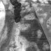
On-line Digital Images |
SC 2468213 |
Records of the Ordnance Survey, Southampton, Hampshire, England |
Rosebank, NX89SE 37, Ordnance Survey index card, Recto |
1958 |
Item Level |
|


