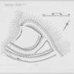
|
Prints and Drawings |
KBD 19/1 |
Records of the Royal Commission on the Ancient and Historical Monuments of Scotland (RCAHMS), Edinbu |
Inked drawing: Waterside earthwork. |
3/10/1952 |
Item Level |
|
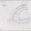
|
Prints and Drawings |
KBD 19/2 |
Records of the Royal Commission on the Ancient and Historical Monuments of Scotland (RCAHMS), Edinbu |
Plane-table survey: Waterside earthwork. |
3/10/1952 |
Item Level |
|
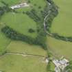 |
On-line Digital Images |
DP 082477 |
RCAHMS Aerial Photography Digital |
Oblique aerial view centred on the earthwork, taken from the NNE. |
21/6/2010 |
Item Level |
|
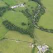 |
On-line Digital Images |
DP 082478 |
RCAHMS Aerial Photography Digital |
Oblique aerial view centred on the earthwork, taken from the NNE. |
21/6/2010 |
Item Level |
|
|
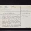
Manuscripts |
MS 36/173 |
Records of the Royal Commission on the Ancient and Historical Monuments of Scotland (RCAHMS), Edinbu |
Field notebook of K A Steer (RCAHMS). 'S6 - Kirkcudbright, Wigtown'. |
17/5/1951 |
Item Level |
|
 |
On-line Digital Images |
DP 148866 |
Records of the Royal Commission on the Ancient and Historical Monuments of Scotland (RCAHMS), Edinbu |
Inked drawing: Waterside earthwork. |
c. 1959 |
Item Level |
|
 |
On-line Digital Images |
DP 148867 |
Records of the Royal Commission on the Ancient and Historical Monuments of Scotland (RCAHMS), Edinbu |
Plane-table survey: Waterside earthwork. |
3/10/1952 |
Item Level |
|
 |
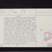
Digital Files (Non-image) |
WP 000778 |
Records of the Royal Commission on the Ancient and Historical Monuments of Scotland (RCAHMS), Edinbu |
Scanned copy of RCAHMS Marginal Land Survey unpublished typescripts (Kircudbrightshire). |
1951 |
Item Level |
|
 |
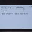
On-line Digital Images |
SC 2467553 |
Records of the Ordnance Survey, Southampton, Hampshire, England |
Waterside, NX86NW 4, Ordnance Survey index card, page number 1, Recto |
1958 |
Item Level |
|
 |
On-line Digital Images |
SC 2467554 |
Records of the Ordnance Survey, Southampton, Hampshire, England |
Waterside, NX86NW 4, Ordnance Survey index card, page number 2, Verso |
1958 |
Item Level |
|
 |
On-line Digital Images |
SC 2467555 |
Records of the Ordnance Survey, Southampton, Hampshire, England |
Waterside, NX86NW 4, Ordnance Survey index card, page number 3, Recto |
1958 |
Item Level |
|
 |
On-line Digital Images |
SC 2467556 |
Records of the Ordnance Survey, Southampton, Hampshire, England |
Waterside, NX86NW 4, Ordnance Survey index card, Recto |
1958 |
Item Level |
|
|
All Other |
551 166/1/1 |
Records of the Ordnance Survey, Southampton, Hampshire, England |
Archaeological site card index ('495' cards) |
1947 |
Sub-Group Level |
|


