|
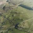
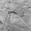
Photographs and Off-line Digital Images |
E 23091 |
RCAHMS Aerial Photography |
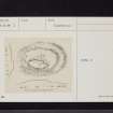
Oblique aerial view centred on the remains of the settlement, taken from the NW. |
28/3/2002 |
Item Level |
|
|
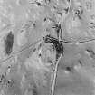
Photographs and Off-line Digital Images |
E 23092 |
RCAHMS Aerial Photography |
Oblique aerial view centred on the remains of the settlement, taken from the W. |
28/3/2002 |
Item Level |
|
|
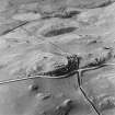
Photographs and Off-line Digital Images |
E 23093 |
RCAHMS Aerial Photography |
Oblique aerial view centred on the remains of the settlement, taken from the WSW. |
28/3/2002 |
Item Level |
|
|
Photographs and Off-line Digital Images |
E 23094 |
RCAHMS Aerial Photography |
Oblique aerial view centred on the remains of the settlement, taken from the SSE. |
28/3/2002 |
Item Level |
|
|
Photographs and Off-line Digital Images |
E 11486 CN |
RCAHMS Aerial Photography |
Oblique aerial view centred on the remains of the settlement, taken from the N. |
28/3/2002 |
Item Level |
|
|
Photographs and Off-line Digital Images |
E 11487 CN |
RCAHMS Aerial Photography |
Oblique aerial view centred on the remains of the settlement, taken from the NW. |
28/3/2002 |
Item Level |
|
|
Manuscripts |
MS 36/173 |
Records of the Royal Commission on the Ancient and Historical Monuments of Scotland (RCAHMS), Edinbu |
Field notebook of K A Steer (RCAHMS). 'S6 - Kirkcudbright, Wigtown'. |
17/5/1951 |
Item Level |
|
 |
Digital Files (Non-image) |
WP 000778 |
Records of the Royal Commission on the Ancient and Historical Monuments of Scotland (RCAHMS), Edinbu |
Scanned copy of RCAHMS Marginal Land Survey unpublished typescripts (Kircudbrightshire). |
1951 |
Item Level |
|
 |
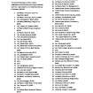
On-line Digital Images |
SC 1756700 |
RCAHMS Aerial Photography |
Oblique aerial view centred on the remains of the settlement, taken from the N. |
28/3/2002 |
Item Level |
|
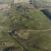 |
On-line Digital Images |
SC 1756701 |
RCAHMS Aerial Photography |
Oblique aerial view centred on the remains of the settlement, taken from the NW. |
28/3/2002 |
Item Level |
|
 |
On-line Digital Images |
SC 1756752 |
RCAHMS Aerial Photography |
Oblique aerial view centred on the remains of the settlement, taken from the NW. |
28/3/2002 |
Item Level |
|
 |
On-line Digital Images |
SC 1756753 |
RCAHMS Aerial Photography |
Oblique aerial view centred on the remains of the settlement, taken from the W. |
28/3/2002 |
Item Level |
|
 |
On-line Digital Images |
SC 1756754 |
RCAHMS Aerial Photography |
Oblique aerial view centred on the remains of the settlement, taken from the WSW. |
28/3/2002 |
Item Level |
|
 |
On-line Digital Images |
SC 1756755 |
RCAHMS Aerial Photography |
Oblique aerial view centred on the remains of the settlement, taken from the SSE. |
28/3/2002 |
Item Level |
|
 |
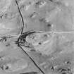
On-line Digital Images |
SC 2466359 |
Records of the Ordnance Survey, Southampton, Hampshire, England |
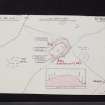
Castlecreavie, NX74NW 3, Ordnance Survey index card, Recto |
1958 |
Item Level |
|
 |
On-line Digital Images |
SC 2466360 |
Records of the Ordnance Survey, Southampton, Hampshire, England |
Castlecreavie, NX74NW 3, Ordnance Survey index card, page number 1, Recto |
1958 |
Item Level |
|
 |
On-line Digital Images |
SC 2466361 |
Records of the Ordnance Survey, Southampton, Hampshire, England |
Castlecreavie, NX74NW 3, Ordnance Survey index card, page number 2, Verso |
1958 |
Item Level |
|
 |
On-line Digital Images |
SC 2466362 |
Records of the Ordnance Survey, Southampton, Hampshire, England |
Castlecreavie, NX74NW 3, Ordnance Survey index card, page number 1, Recto |
1958 |
Item Level |
|
 |
On-line Digital Images |
SC 2466363 |
Records of the Ordnance Survey, Southampton, Hampshire, England |
Castlecreavie, NX74NW 3, Ordnance Survey index card, Recto |
1958 |
Item Level |
|
|
All Other |
551 166/1/1 |
Records of the Ordnance Survey, Southampton, Hampshire, England |
Archaeological site card index ('495' cards) |
1947 |
Sub-Group Level |
|


