
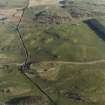
Castlecreavie


Settlement (Period Unassigned)
Site Name Castlecreavie
Classification Settlement (Period Unassigned)
Canmore ID 64427
Site Number NX74NW 3
NGR NX 7237 4925
Datum OSGB36 - NGR
Permalink http://canmore.org.uk/site/64427


- Council Dumfries And Galloway
- Parish Rerrick
- Former Region Dumfries And Galloway
- Former District Stewartry
- Former County Kirkcudbrightshire
NX74NW 3 7236 4925.
(NX 7237 4925) Earthwork (NR)
OS 6" map (1957)
Fort
F R Coles 1891; RCAHMS 1914, visited 1911
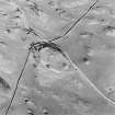
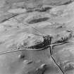
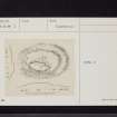
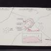
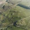
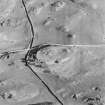
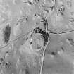
On an elongated natural hillock which falls away gradually to the SW are the remains of a settlement. Oval on plan it measures 66.0m NW-SE x 36.0m transversely and consists of an earth and stone rampart now reduced to a scarp except on the NE and SW. Below this a terrace 3.0 to 4.0m wide extends around the hillock except on the SW. Although this may be contemporary with the settlement it has clearly been used for later cultivation. The interior is featureless.
The absence of multiple ramparts across the naturally weak SW side argues for this being a settlement rather than a fort.
Resurveyed at 1/2500.
Visited by OS (RD) 3 February 1971.
Field Visit (12 May 1952)
This site was included within the RCAHMS Marginal Land Survey (1950-1962), an unpublished rescue project. Site descriptions, organised by county, are available to view online - see the searchable PDF in 'Digital Items'. These vary from short notes, to lengthy and full descriptions. Contemporary plane-table surveys and inked drawings, where available, can be viewed online in most cases - see 'Digital Images'. The original typecripts, notebooks and drawings can also be viewed in the RCAHMS search room.
Information from RCAHMS (GFG) 19 July 2013.

