 |
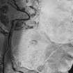
On-line Digital Images |
SC 1756549 |
RCAHMS Aerial Photography |
Aerial view of Loch Mannoch carin and stone circle, taken from the S. |
6/3/1997 |
Item Level |
|
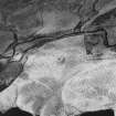 |
On-line Digital Images |
SC 1756550 |
RCAHMS Aerial Photography |
Aerial view of Loch Mannoch cairns and stone circle, taken from the E. |
6/3/1997 |
Item Level |
|
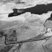 |
On-line Digital Images |
SC 1756552 |
RCAHMS Aerial Photography |
Aerial view of Loch Mannoch cairns and stone circle, taken from the NW. |
6/3/1997 |
Item Level |
|
 |
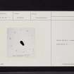
On-line Digital Images |
SC 2465950 |
Records of the Ordnance Survey, Southampton, Hampshire, England |
Loch Mannoch, NX66SE 2, Ordnance Survey index card, Recto |
1958 |
Item Level |
|
 |
On-line Digital Images |
SC 2465951 |
Records of the Ordnance Survey, Southampton, Hampshire, England |
Loch Mannoch, NX66SE 2, Ordnance Survey index card, Recto |
1958 |
Item Level |
|
 |
On-line Digital Images |
SC 2465952 |
Records of the Ordnance Survey, Southampton, Hampshire, England |
Loch Mannoch, NX66SE 2, Ordnance Survey index card, Recto |
1958 |
Item Level |
|
 |
On-line Digital Images |
SC 2465953 |
Records of the Ordnance Survey, Southampton, Hampshire, England |
Loch Mannoch, NX66SE 2, Ordnance Survey index card, Recto |
1958 |
Item Level |
|
 |
On-line Digital Images |
SC 2465954 |
Records of the Ordnance Survey, Southampton, Hampshire, England |
Loch Mannoch, NX66SE 2, Ordnance Survey index card, Recto |
1958 |
Item Level |
|


