|
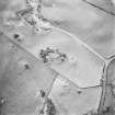
Photographs and Off-line Digital Images |
D 76514 |
RCAHMS Aerial Photography |
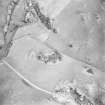
Oblique aerial view centred on the remains of the fort, taken from the WSW. |
11/12/2000 |
Item Level |
|
|
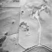
Photographs and Off-line Digital Images |
D 76515 |
RCAHMS Aerial Photography |
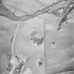
Oblique aerial view centred on the remains of the fort, taken from the SSW. |
11/12/2000 |
Item Level |
|
|
Photographs and Off-line Digital Images |
D 76516 |
RCAHMS Aerial Photography |
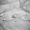
Oblique aerial view centred on the remains of the fort, taken from the SE. |
11/12/2000 |
Item Level |
|
|
Photographs and Off-line Digital Images |
D 76517 |
RCAHMS Aerial Photography |
Oblique aerial view centred on the remains of the fort, taken from the ENE. |
11/12/2000 |
Item Level |
|
|
Photographs and Off-line Digital Images |
D 76518 |
RCAHMS Aerial Photography |
Oblique aerial view centred on the remains of the fort, taken from the NNE. |
11/12/2000 |
Item Level |
|
|
Manuscripts |
MS 36/173 |
Records of the Royal Commission on the Ancient and Historical Monuments of Scotland (RCAHMS), Edinbu |
Field notebook of K A Steer (RCAHMS). 'S6 - Kirkcudbright, Wigtown'. |
17/5/1951 |
Item Level |
|
 |
Digital Files (Non-image) |
WP 000778 |
Records of the Royal Commission on the Ancient and Historical Monuments of Scotland (RCAHMS), Edinbu |
Scanned copy of RCAHMS Marginal Land Survey unpublished typescripts (Kircudbrightshire). |
1951 |
Item Level |
|
 |
On-line Digital Images |
SC 1756482 |
RCAHMS Aerial Photography |
Oblique aerial view centred on the remains of the fort, taken from the WSW. |
11/12/2000 |
Item Level |
|
 |
On-line Digital Images |
SC 1756483 |
RCAHMS Aerial Photography |
Oblique aerial view centred on the remains of the fort, taken from the SSW. |
11/12/2000 |
Item Level |
|
 |
On-line Digital Images |
SC 1756484 |
RCAHMS Aerial Photography |
Oblique aerial view centred on the remains of the fort, taken from the SE. |
11/12/2000 |
Item Level |
|
 |
On-line Digital Images |
SC 1756485 |
RCAHMS Aerial Photography |
Oblique aerial view centred on the remains of the fort, taken from the ENE. |
11/12/2000 |
Item Level |
|
 |
On-line Digital Images |
SC 1756486 |
RCAHMS Aerial Photography |
Oblique aerial view centred on the remains of the fort, taken from the NNE. |
11/12/2000 |
Item Level |
|
 |
On-line Digital Images |
SC 2465679 |
Records of the Ordnance Survey, Southampton, Hampshire, England |
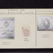
Arden, NX65SE 1, Ordnance Survey index card, Recto |
1958 |
Item Level |
|
 |
On-line Digital Images |
SC 2465680 |
Records of the Ordnance Survey, Southampton, Hampshire, England |
Arden, NX65SE 1, Ordnance Survey index card, page number 1, Recto |
1958 |
Item Level |
|
 |
On-line Digital Images |
SC 2465681 |
Records of the Ordnance Survey, Southampton, Hampshire, England |
Arden, NX65SE 1, Ordnance Survey index card, page number 2, Verso |
1958 |
Item Level |
|
 |
On-line Digital Images |
SC 2465682 |
Records of the Ordnance Survey, Southampton, Hampshire, England |
Arden, NX65SE 1, Ordnance Survey index card, Recto |
1958 |
Item Level |
|
|
All Other |
551 166/1/1 |
Records of the Ordnance Survey, Southampton, Hampshire, England |
Archaeological site card index ('495' cards) |
1947 |
Sub-Group Level |
|


