
Castle Haven


Dun (Medieval)
Site Name Castle Haven
Classification Dun (Medieval)
Alternative Name(s) Castle Haven Bay
Canmore ID 63623
Site Number NX54NE 3
NGR NX 59347 48270
Datum OSGB36 - NGR
Permalink http://canmore.org.uk/site/63623


- Council Dumfries And Galloway
- Parish Borgue
- Former Region Dumfries And Galloway
- Former District Stewartry
- Former County Kirkcudbrightshire
NX54NE 3 59347 48270.
(NX 5934 4827) Castle Haven (NAT) Broch (NR).
OS 6" map (1957)
(NX 5935 4825) Human Remains found AD 1905 (NAT).
OS 6" map (1910)
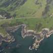
Castle Haven: This galleried dun, cleared of rubble and partly reconstructed in 1905 by James Brown of Knockbrex, is D-shaped and stands partly on the chord of and partly within a large enclosure of similar shape, which may or may not be contemporary. The dun measures 60' by 35' within c.15' thick walls; the outer court measuring twice as much. Barbour also notes a line of rampart extending from the NE side of the dun, running SE for c.350' then turning SW for c.230' till it meets the shore, thereby enclosing the promontory.
Relics found during the clearance include both Early Iron Age and 8th/9th century objects, as well as a human skeleton which was found on the floor of the outer court, against the E wall of the central structure.
R W Feachem 1963; J Barbour 1907; A E Truckell 1963
Castle Haven (name confirmed), as described and planned above, but nothing could be made of Barbour's 'rampart' on the east side. It is in good condition.
Resurveyed at 1/2500.
Visited by OS (WDJ) 26 January 1971
Two bronze spiral finger-rings.
E J MacKie 1971
Field Visit (14 June 1951)
This site was included within the RCAHMS Marginal Land Survey (1950-1962), an unpublished rescue project. Site descriptions, organised by county, are available to view online - see the searchable PDF in 'Digital Items'. These vary from short notes, to lengthy and full descriptions. Contemporary plane-table surveys and inked drawings, where available, can be viewed online in most cases - see 'Digital Images'. The original typecripts, notebooks and drawings can also be viewed in the RCAHMS search room.
Information from RCAHMS (GFG) 19 July 2013.
Publication Account (1986)
This extraordinary structure, which stands on the rocky foreshore at Kirkandrews, is as much a monument to the energetic enthusiasm of early 20th century antiquarians as to the needs and aspirations of an iron-age chieftain. It is Galloway's only known example of a galleried dun, a type of fortifIed homestead common in Argyll and the Western Isles. Castle Haven differs from its cousins of the western seaboard in a number of ways, and first impressions suggest that the height and condition of its drystone walls are one of its distinguishing features. However, its remarkable condition is the result of clearance and restoration work carried out in 1905 by its owner, the laird of Knockbrex, partly with the aim of 'rendering it less liable to be trampled and destroyed than ifleft in the state in which it was . . .'. Before 1905 none of the walls was more than 1.2m in height, and the west wall, which runs along the rocky edge of Castle Haven Bay, was merely foundations.
Unlike the Argyll duns, this does not preserve evidence of an intra-mural stair; the upper levels were reached by stile-like stone slabs projecting from inner wall faces. The roughly concentric outer enclosure, some 7.3m in average width, is also an unusual and possibly later feature; it has entrances in the north-eastern and south-eastern sectors, the former corresponding with the main entrances to the inner court.
Although dramatically altering the height of the fortifIcation, the restoration faithfully followed its outline. Backing against the straightish west wall the dun is D-shaped on plan, 18.3m by 10.7m in maximum dimensions, with its main entrance in the north-eastern sector; a stepped gateway in the southwall gave access to a boat-landing on the shore below. Within the thickness of the walls there are three narrow galleries of different lengths, which are linked to the interior by no less than six doorways.
The artefacts found in the excavations included bronze spiral finger-rings and a bead of blue glass paste, reflecting sophisticated iron-age origins, whilst pieces of mail and a late type of bronze penannular brooch indicated medieval occupation. There are traditions of an association with the Balliols, and it is possible that in the 14th century the site served as a refuge for Edward Balliol, the last member of the main branch of that family.
Information from ‘Exploring Scotland’s Heritage: Dumfries and Galloway’, (1986).
Publication Account (2007)
NX54 1 CASTLE HAVEN
NX/500400
This galleried dun within a larger ‘fortified camp’ in Borgue was excavated and partly reconstructed by James Brown of Knockbrex in 1905 (visited in 1967). It is highly unusual in this part of Scotland both in having a clearly galleried wall all the way round – which puts it close to the broch class of buildings architecturally – and also in having yielded a few clear Iron Age finds of high quality. The absence of an intra-mural stair precludes Castle Haven being classed as a semibroch which its D-shaped plan suggests. The original report [2] was accompanied by several photographs (taken after the reconstruct-ion work) which were reproduced in the Royal Commission’s account [3]. Judging from the author’s 1967 photographs much of the rebuilt walling of 1905 has been taken off again.
Description
The drystone stronghold stands just within the north-west end of a rampart which runs in two straight lengths – south-east from it for about 107m (350 ft) and then south-west for about 70m (230 ft) to the rocky shore – to cut off a large promontory. It is built next to a rock face 6.1m (20 ft) high and immediately above the shore. There are two elements to the building, namely an inner, roughly D-shaped building (the straight edge running along a low cliff) with a galleried wall and an outer wall (attached to the dun wall on the north and south) apparently solid. Little of the latter could be seen in 1967 under the vegetation.
The main entrance, 4.58m (15 ft) long and unusually wide at 2.12m (7 ft), is on the north-east. There is a door-frame halfway down the passage which was said to be formed of projecting stone slabs but which is in fact formed of massive built rebates; no mention was made of bar-hole and socket but the latter can be seen just behind the left rebate. There is a subsidiary, narrower entrance (0.76m or 2 ft 6 in wide) on the south the floor of which is formed of eight descending steps leading to a few more outside which take one down to the rocky shore.
Three lengths of gallery are within the wall. The first runs along the eastern and southern parts of the wall on the landward side and is entered by three doorways as well as by the subsidiary entrance passage. The second is a short length in the straight (western) wall and just west of the passage mentioned; it has one doorway. The third – with two doorways – runs along the northern half of the straight wall and round towards the main entrance. The dimensions of the central court are given as 18.3m (60 ft) north-south and 10.7m (35 ft) east-west.
No stairway was found in any of these intra-mural galleries but immediately east of the main entrance, on the inside face, was found a set of projecting stone slabs forming a short flight of steps; these can be seen on the early photograph of the same area [2, fig. 6]. Such steps doubtless served to reach the walhead which is therefore not likely to have been very high when constructed. Similar flights of steps were noted at three separate places on the inner face of the outer wall.
Also on the early photographs are what appear to be several irregular scarcements, or more likely rows of pale stone blocks, on the inside wallface; certainly nothing like ledges was seen in 1967 and they are not mentioned in Barbour’s report [2].
Restoration work
Barbour describes the original state of the walls before restoration [2, 77-8] and notes that the primary wall nowhere stood more than about 1.2m (4 ft), and that it was down to its foundations on the west side. However everywhere the line of the walls could be made out, and the positions of the doorways determined, from the foundation blocks. It may be that the lines of white stones seen in the old photographs indicate the levels at which restoration started. Lintels were put back on some of the doorways.
Finds
No information is available about the contexts of the finds.
Iron: a number of small rings about 6mm (0.25 in) in diameter and partly interlaced, evidently the remains of a fragment of chain mail; other fragments of iron (none of these are illustrated).
Bronze: 2 plain spiral finger-rings (Illus), 1 penannular brooch, without the pin, of Fowler’s Type E .
Glass: 1 thick, ring-shaped bead of blue glass marked with a wavy line of white glass round the edge.
Amber: 1 ring or bead with a circular cross-section (not illus.).
Stone (only the polished disc of speckled stone is illustrated): 1 upper stone of a rotary quern, several fragments of similar quern stones, 1 cylindrical pounder, several whetstones, 1 water worn stone with a rounded end, perhaps a pounder, 1 rough perforated disc 90cm (3.5 in) in diameter, 1 polished, perforated sub-circular disc, diams. 5.7 and 5.0cm (2.25 and 2 in), 3 fragments of a polished disc made from a speckled stone, diam. c. 7.7cm (3 in): 1 ‘burnisher’.
Discussion
Castle Haven is an unusual and interesting site and one can only regret that it was cleared out in a relatively perfunctory manner at an early stage in the development of systematic archaeological exploration.
Sources: 1. NMRS site no. NX 54 NE 3: 2. Barbour 1907: 3. RCAHMS 1912, 46-48 and figs. 39-44: 4. Feachem 1963, 182: 5. Truckle 1963, 89: 6. Stell 1986, 129, no. 54.
E W MacKie 2007

