
Doon


Fort (Prehistoric)
Site Name Doon
Classification Fort (Prehistoric)
Alternative Name(s) Knockbrex
Canmore ID 63621
Site Number NX54NE 1
NGR NX 5876 4935
Datum OSGB36 - NGR
Permalink http://canmore.org.uk/site/63621


- Council Dumfries And Galloway
- Parish Borgue
- Former Region Dumfries And Galloway
- Former District Stewartry
- Former County Kirkcudbrightshire
Field Visit (29 September 1911)
No. 61 Fort, Knockbrex
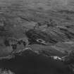
Immediately to the east of the gardener’s house at Knockbrex, which is approached by a short roadway opening off the high road opposite the south entrance to Knockbrex, is a fort fashioned by the formation of double trenches with intervening ramparts across a long narrow ridge at either end of the enclosure. The main axis lies north-east and south-west, along which line the interior measures 100 feet, and at right angles to it near the centre 65 feet. From the bottom of the ridge on the north-west side there is a steep inclination of about 30 feet, and on the opposite side a rise of about 8 feet. The remains of stonework are visible at the edge of the scarp around the interior. At the south corner a roadway some 10 feet wide opens on a hollow in the interior, around the inner side of which there appears to be some building. At the north-east end the trenches are each some 20 feet in width and 8 feet and 11 feet in width, while at the south-west they are about 26 feet in width and 6 feet and 5 feet 3 inches in depth respectively below the summit level.
Visited by RCAHMS (AOC) 29 September 1911
Field Visit (15 June 1951)
'Fort', Knockbrex (Site), (Inventory No. 61). This work has now been completely obliterated. Cited location 586 493.
Visited by RCAHMS (KAS) 15 June 1951
Desk Based Assessment (12 August 1970)
NX54NE 1 5870 4933.
(NX 5870 4933) Doon (NR)
OS 6" map (1957)
In 1951, nothing remained of this fort which was situated on the summit of a narrow ridge with a steep drop of 30' to the NW, and 8' to SE. It is described in 1911 as having two ramparts and ditches, measuring internally 100' NE-SW by 65' transversely. At the S corner a 10' wide roadway opened on a hollow in the interior, around the inner side of which there appeared some building. At the NE end the ditches were 20' wide and 8' and 11' deep, while at the SW they were c.26' wide and 6' and 5'3" deep.
Information from OS (IF) 12 August 1970
Sources: RCAHMS 1914, visited 1911; TS. 15 June 1951
Field Visit (25 January 1971)
Nothing remains of this fort.
Visited by OS (WDJ) 25 January 1971
Note (16 May 2016 - 18 May 2016)
A small fort is situated on an elongated hillock in the deciduous woodland to the E of Doon Wood Cottage. First described by Alexander Curle in 1912 during the preparation of the County Inventory for the Stewartry of Kirkcudbright (RCAHMS 1914, 45, no.61), the site has been lost since, largely on the account of the depiction that appears on the OS 25-inch map surveyed in 1894 (Kircudbrightshire 1895, sheet 54.5), which places the Doon immediately SW of what was then called Barlocco Croft, now Doon Wood Cottage, and has drawn most investigators to the wrong location. As described by Curle, the defences comprise 'double trenches with intervening ramparts' drawn across the ends of the hillock on the NE and SW respectively, though only the inner rampart could be traced along the crest of the slope on its flanks, which drop away some 9m on the NW and 2.7m on the SE. The stature of the defences is greatest on the NE, where the crests of the ramparts stand 2.7m and 3.3m above the bottoms of the ditches, but the entrance is on the S, opening into an internal hollow. The interior measures about 30m in length by 20m in breadth (0.05ha).
Information from An Atlas of Hillforts of Great Britain and Ireland – 18 May 2016. Atlas of Hillforts SC4341

