
Dun Carnachaidh


Broch (Iron Age)(Possible)
Site Name Dun Carnachaidh
Classification Broch (Iron Age)(Possible)
Alternative Name(s) Cnoc Carnachadh; Carnachy
Canmore ID 6362
Site Number NC75SW 8
NGR NC 7213 5269
Datum OSGB36 - NGR
Permalink http://canmore.org.uk/site/6362


- Council Highland
- Parish Farr
- Former Region Highland
- Former District Sutherland
- Former County Sutherland
NC75SW 8 7213 5269.
(NC 7213 5269) Broch (NR)
OS 6" map, (1962)
The remains of a broch on a cliff overlooking the river valley. A later structure, possibly a shelter, has been built into the wall on the west.
Visited by OS (J L D) 6 May 1960.
RCAHMS 1911, visited 1909.
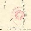
Situated on the edge of a natural shelf is a broch measuring about 9.2m in diameter within a wall 4.1m to 4.8m wide. The lower courses of the inner and outer faces are visible to some extent, and there are traces of a mural gallery protruding through the tumble in the west arc.
The entrance was presumably in the north, but no structural details are exposed. An outer defence surviving in scant traces of a wall, encircles the broch on all sides but the east where the steep slope provides a natural barrier. The broch is in line with the ruins of an early modern head dyke; the possible shelter noted by previous authorities cannot be located and may refer to the mural gallery.
Revised at 1:10,000.
Visited by OS (N K B) 30 January 1979.
Scheduled as Cnoc Carnachadh, broch. The remains of this broch stand on the edge on a natural terrace on the W side of Strathnaver, and are surrounded by a low bank and a ditch.
Information from Historic Scotland, scheduling document dated 20 January 2003.
Publication Account (2007)
NC75 3 DUN CARNACHAIDH ('Dun Carnachie')
NC/72l3 5269
Probable broch in Farr, Sutherland, standing on a cliff overlooking the river valley, at about 45m OD. It consists now of a mound of fallen stone but was described as a “Pictish tower” in 1867 [4, 272]. The inner wallface is visible and indicates an internal diameter of about 9.2 m; the wall is 4.1-4.8m thick [1], or 4.8-5.0m [4]. The lower courses of the inner and outer wallfaces are visible in places, the latter as a line of massive boulders [4]. There are traces of an intra-mural gallery on the west arc. No clear signs of an entrance are apparent although Swanson suggests that an earth-fast upright slab on the west, immediately south of the mural gallery mentioned, might be a door-check [4].
There are signs of what seems to be the outer face of an outer wall 6m from the broch on the north and 4m on the south-west [4, plan].
Sources: 1. NMRS site no. NC 75 SW 8: 2. RCAHMS 1911a, 60, no. 180: 3. Horsburgh 1867: 4. Swanson (ms) 1985, 724-26 and plan.
E W MacKie 2007

