
Wigtown Castle


Castle (Medieval)
Site Name Wigtown Castle
Classification Castle (Medieval)
Canmore ID 63343
Site Number NX45NW 2
NGR NX 43722 55003
Datum OSGB36 - NGR
Permalink http://canmore.org.uk/site/63343


- Council Dumfries And Galloway
- Parish Wigtown
- Former Region Dumfries And Galloway
- Former District Wigtown
- Former County Wigtownshire
NX45NW 2 43722 55003
(Name: NX 43722 55003) Wigtown Castle (NR) (Site of)
OS 6" map (1957)
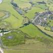
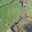
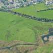
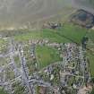
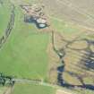
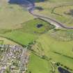
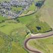
Wigtown Castle, in use between c.1260-c.1315 (A E Truckell and J Williams 1967) was situated beside the Bladenoch (which has now changed its course), S of the town. Its site was circular, about half an acre in size, fortified on all sides by a wall of stone and lime. The wall was surrounded by the sea on the E and S, and on the W and N by a ditch c. 30' wide and 10' deep, which, admitting the tide, led round the castle. Nothing now remains of the building, and the ground has long been ploughed up.
It was excavated in 1830 by Capt. R M'Kerlie, when the ditch was clearly seen on the N, where also a semi-circular ridge, of considerable elevation, was accurately traced, this being the remains of the outer wall. The drawbridge and gate were on the SW front of the castle.
The castle was handed over to Edward I in 1291, but retaken by Wallace in 1297, and was probably destroyed by Bruce.
P H M'Kerlie 1870; R C Reid 1878
NX 4371 5500 The site of the castle is bounded on the N by a wide moat while a slight scarp marks the S side. The interior has been quarried.
Resurveyed at 1:2500.
Visited by OS (RD) 18 August 1970.
Publication Account (1981)
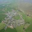
The castle of Wigtown was in existence by 1291. It was located on flat land down by the river, while the town and church were on a hill, 'an inversion of the usual arrangements' (Reid, 1924-25, 240). Nothing remains of the structure although a strong natural site and indication of a large enclosed and defended area seems to point to a castle of the Edwardian type, dating from the end of the thirteenth century (RCAM, 1912, i, 180). The site of the castle was excavated after a fashion about 1830, by a Captain Robert Kerlie and a team of volunteers. The outlines of a building were clearly traced on this occasion and a ditch, which had been broad, was distinctly seen on the north, where there was also a semi-circular ridge of considerable elevation said to be the remains of the castle's outer wall (ML Kerlie, 1870, i, 331-2). Within a matter of years following the 'excavation', the reporter in the New Statistical Account wrote that a fosse was quite discernible, although 'the foundations of the walls cannot now be traced' (NSA, 1841, 2). Mortar and 'other remains indicative of an ancient building' were still to be observed (NSA, 1841, 2).
The castle's history is virtually unknown. Bruce may have issued orders for its demolition. The only known hint of its existence after the period of the Wars of Independence occurs in a charter of 1451 when a turris (tower) of Wigtown is mentioned (Reid, 1924-5, 241). Its convenience as a local quarry undoubtedly accounts for its total disappearance.
Information from ‘Historic Wigtown: The Archaeological Implications of Development’ (1981).

