 |
On-line Digital Images |
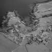
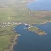
SC 503651 |
RCAHMS Aerial Photography |
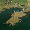
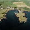
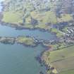
Oblique aerial view, taken from the N, centred on the village and harbour, and showing Isle Head fort and the remains of St. Ninian's Chapel in the top left-hand corner of the photograph. |
22/6/1995 |
Item Level |
|
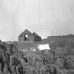 |
On-line Digital Images |
SC 695089 |
Papers of Helen Cameron Nisbet, geologist and archaeologist, Lasswade, Midlothian, Scotland |
Black and white slide, view of Saint Ninian's Kirk Isle of Whithorn
NMRS Survey of Private Collection
Digital Image Only |
c. 1950 |
Item Level |
|
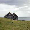 |
On-line Digital Images |
SC 695090 |
Papers of Helen Cameron Nisbet, geologist and archaeologist, Lasswade, Midlothian, Scotland |
Colour slide, view of Saint Ninian's Kirk Isle of Whithorn
NMRS Survey of Private Collection
Digital Image Only |
26/6/1962 |
Item Level |
|
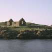 |
On-line Digital Images |
SC 709597 |
Papers of Helen Cameron Nisbet, geologist and archaeologist, Lasswade, Midlothian, Scotland |
Copy of colour slide showing general view of Whithorn Kirk, Isle of Whithorn
NMRS Survey of Private Collection
Digital Image Only |
3/1975 |
Item Level |
|
 |
On-line Digital Images |
SC 709607 |
Papers of Helen Cameron Nisbet, geologist and archaeologist, Lasswade, Midlothian, Scotland |
Copy of colour slide showing view of Whithorn Kirk, Isle of Whithorn
NMRS Survey of Private Collection
Digital Image Only |
3/1975 |
Item Level |
|
 |
On-line Digital Images |
SC 709612 |
Papers of Helen Cameron Nisbet, geologist and archaeologist, Lasswade, Midlothian, Scotland |
Copy of colour slide showing detail of east end interior of Whithorn Kirk, Isle of Whithorn
NMRS Survey of Private Collection
Digital Image Only |
3/1975 |
Item Level |
|
 |
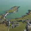
On-line Digital Images |
SC 973223 |
RCAHMS Aerial Photography |
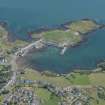
Oblique aerial view centred on the village, harbour, and the remains of the chapel and promontory fort, taken from the ESE. |
27/7/1999 |
Item Level |
|
 |
On-line Digital Images |
SC 973224 |
RCAHMS Aerial Photography |
General oblique aerial view centred on the village, harbour, and the remains of the chapel and promontory fort, taken from the SSE. |
27/7/1999 |
Item Level |
|
 |
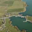
On-line Digital Images |
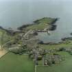
DP 012498 |
RCAHMS Aerial Photography Digital |
General oblique aerial view centred on the village with the tower house and remains of the promontory fort and chapel adjacent, taken from the NW. |
2/3/2006 |
Item Level |
|
 |
On-line Digital Images |
DP 012500 |
RCAHMS Aerial Photography Digital |
General oblique aerial view centred on the village with the tower house and remains of the promontory fort and chapel adjacent, taken from the SW. |
2/3/2006 |
Item Level |
|
 |
On-line Digital Images |
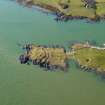
DP 012502 |
RCAHMS Aerial Photography Digital |
Oblique aerial view centred on the remains of the promontory fort and the chapel, taken from the SW. |
2/3/2006 |
Item Level |
|
 |
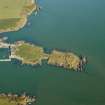
On-line Digital Images |
DP 012505 |
RCAHMS Aerial Photography Digital |
Oblique aerial view centred on the remains of the promontory fort and the chapel, taken from the ENE. |
2/3/2006 |
Item Level |
|
 |
On-line Digital Images |
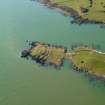
DP 012507 |
RCAHMS Aerial Photography Digital |
Oblique aerial view centred on the remains of the promontory fort and the chapel, taken from the NE. |
2/3/2006 |
Item Level |
|
 |
On-line Digital Images |
DP 012509 |
RCAHMS Aerial Photography Digital |
Oblique aerial view centred on the remains of the promontory fort and the chapel, taken from the NE. |
2/3/2006 |
Item Level |
|
 |
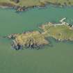
On-line Digital Images |
SC 1102369 |
RCAHMS Aerial Photography |
Oblique aerial view centred on the village with the remains of the promontory fort and chapel adjacent, taken from the NW. |
28/6/2002 |
Item Level |
|
 |
On-line Digital Images |
SC 1102370 |
RCAHMS Aerial Photography |
General oblique aerial view centred on the village, harbour, and the remains of the chapel and promontory fort, taken from the SSW. |
27/7/1999 |
Item Level |
|
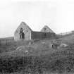 |
On-line Digital Images |
SC 1165678 |
Historic Buildings and Monuments/Scottish Development Department photographs |
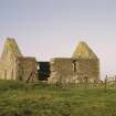
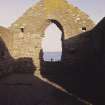
View from NE. |
|
Item Level |
|
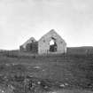 |
On-line Digital Images |
SC 1165679 |
Historic Buildings and Monuments/Scottish Development Department photographs |
View from NE. |
|
Item Level |
|
 |
On-line Digital Images |
DP 147947 |
RCAHMS Aerial Photography Digital |
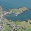
General oblique aerial view of Isle of Whithorn, looking NNW. |
30/11/2012 |
Item Level |
|
 |
On-line Digital Images |
DP 147948 |
RCAHMS Aerial Photography Digital |
General oblique aerial view of Isle of Whithorn, looking W. |
30/11/2012 |
Item Level |
|
 |
On-line Digital Images |
DP 147949 |
RCAHMS Aerial Photography Digital |
General oblique aerial view of Isle of Whithorn, looking WSW. |
30/11/2012 |
Item Level |
|
 |
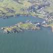
On-line Digital Images |
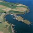
DP 193985 |
RCAHMS Aerial Photography Digital |
Oblique aerial view of the Isle of Whithorn and Isle Head, looking E. |
25/7/2014 |
Item Level |
|
 |
On-line Digital Images |
DP 193986 |
RCAHMS Aerial Photography Digital |
Oblique aerial view of the Isle of Whithorn and Isle Head, looking E. |
25/7/2014 |
Item Level |
|
 |
On-line Digital Images |
DP 261058 |
Historic Environment Scotland |
Oblique aerial view. |
12/7/2017 |
Item Level |
|


