 |
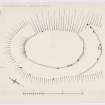
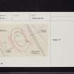
On-line Digital Images |
DP 151578 |
Records of the Royal Commission on the Ancient and Historical Monuments of Scotland (RCAHMS), Edinbu |
RCAHMS Marginal Land Survey inked plan, |
c. 1955 |
Item Level |
|
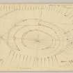 |
On-line Digital Images |
DP 151579 |
Records of the Royal Commission on the Ancient and Historical Monuments of Scotland (RCAHMS), Edinbu |
RCAHMS Marginal Land Survey pencil plane table survey drawing, and 50% reduction. |
9/10/1955 |
Item Level |
|
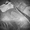 |
On-line Digital Images |
SC 1756369 |
RCAHMS Aerial Photography |
Oblique aerial view. |
1983 |
Item Level |
|
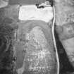 |
On-line Digital Images |
SC 1756370 |
RCAHMS Aerial Photography |
Oblique aerial view. |
1983 |
Item Level |
|
 |
On-line Digital Images |
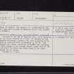
SC 2463546 |
Records of the Ordnance Survey, Southampton, Hampshire, England |
Barnkirk Hill, NX36NE 5, Ordnance Survey index card, page number 1, Recto |
1958 |
Item Level |
|
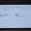 |
On-line Digital Images |
SC 2463547 |
Records of the Ordnance Survey, Southampton, Hampshire, England |
Barnkirk Hill, NX36NE 5, Ordnance Survey index card, Recto |
1958 |
Item Level |
|
 |
On-line Digital Images |
SC 2463548 |
Records of the Ordnance Survey, Southampton, Hampshire, England |
Barnkirk Hill, NX36NE 5, Ordnance Survey index card, Recto |
1958 |
Item Level |
|


